Milsons Point
Videos
Milsons Point is a suburb on the lower North Shore of Sydney, in the state of New South Wales, Australia. The suburb is located 3 kilometres north of the Sydney central business district in the local government area of North Sydney Council.
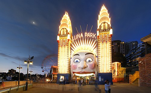
Luna Park at Milsons Point

Milsons Point viewed from McMahons Point, across Lavender Bay

Night view from the F4 ferry
![Postcard of Milsons Point. The caption reads: "Milson’s Point – Probably in the early Seventies [1870s]. Kirribilli on the farther shore. Eastern Road](https://upload.wikimedia.org/wikipedia/commons/thumb/f/f6/Milsons_Point_around_1870s.jpg/500px-Milsons_Point_around_1870s.jpg)
Postcard of Milsons Point. The caption reads: "Milson’s Point – Probably in the early Seventies [1870s]. Kirribilli on the farther shore. Eastern Road Wharf is front. Alfred St to the right, the Arcade and clock are within (illegible)ing distance of the spreading tree."
Warringah Freeway
Videos
Warringah Freeway is a 3.5-kilometre (2.2 mi) divided freeway in Sydney, New South Wales that is part of the Sydney Orbital Network. The primary function of the freeway is to provide an alternative high-grade route from the Sydney Harbour Tunnel and Bradfield Highway at Milsons Point to the A8 and Gore Hill Freeway. The freeway reduces traffic demands on Pacific Highway throughout Sydney's Lower North Shore, bypassing North Sydney and Crows Nest, and provides a vital link to access most of the suburbs in Sydney and is also a major route to the north, south, east and west of the central business district.


Warringah Freeway looking south at its widest point - 16 lanes

View of Warringah Freeway looking north, over the inner western carriageway, during morning peak hour

View of Warringah Freeway looking north, towards the Military Road overpass