1.
Swiss Alps
–
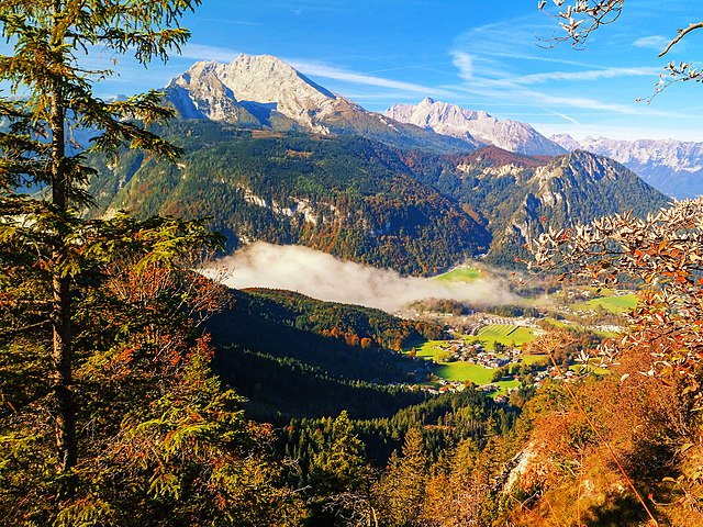
The Swiss Alps extend over both the Western Alps and the Eastern Alps, encompassing an area sometimes called Central Alps. The Swiss Alps comprise almost all the highest mountains of the Alps, such as Dufourspitze, the Dom, the Liskamm, the Weisshorn, the other following major summits can be found in this list of mountains of Switzerland. Since the Middle Ages, transit across the Alps played an important role in history, the region north of St Gotthard Pass became the nucleus of the Swiss Confederacy in the early 14th century. The Alps cover 65% of Switzerlands total 41,285 square kilometres surface area, making it one of the most alpine countries. The glaciers of the Swiss Alps cover an area of 1,220 square kilometres — 3% of the Swiss territory, the Swiss Alps are situated south of the Swiss Plateau and north of the national border. The limit between the Alps and the runs from Vevey on the shores of Lake Geneva to Rorschach on the shores of Lake Constance, passing close to the cities of Thun. The not well defined regions in Switzerland that lie on the margin of the Alps, the Swiss Prealps are mainly made of limestone and they generally do not exceed 2,500 metres. The Alpine cantons are Valais, Bern, Graubünden, Uri, Glarus, Ticino, St. Gallen, Vaud, Obwalden, Nidwalden, Schwyz, Appenzell Innerrhoden, Appenzell Ausserrhoden, Fribourg, Lucerne and Zug. The countries with which Switzerland shares mountain ranges of the Alps are, France, Italy, Austria, the Alps are usually divided into two main parts, the Western Alps and Eastern Alps, whose division is along the Rhine from Lake Constance to the Splügen Pass. The western ranges occupy the greatest part of Switzerland while the more numerous eastern ranges are smaller and are all situated in the canton of Graubünden. The latter are part of the Central Eastern Alps, except the Ortler Alps which belong to the Southern Limestone Alps, the Pennine, Bernese and Bernina Range are the highest ranges of the country, they contain respectively 38,9 and 1 summit over 4000 metres. The lowest range is the Appenzell Alps culminating at 2,500 metres, Western Alps Eastern Alps The north side of the Swiss Alps is drained by the Rhône, Rhine and Inn while the south side is mainly drained by the Ticino. The rivers on the empty into the Mediterranean, North and Black Sea. The major triple watersheds in the Alps are located within the country, they are, Piz Lunghin, Witenwasserenstock, between the Witenwasserenstock and Piz Lunghin runs the European Watershed separating the basin of the Atlantic and the Mediterranean Sea. The European watershed lies in fact only partially on the main chain, Switzerland possesses 6% of Europes fresh water, and is sometimes referred to as the water tower of Europe. Since the highest dams are located in Alpine regions, many mountain lakes are artificial and are used as hydroelectric reservoirs. Some large artificial lakes can be found above 2,300 m, the melting of low-altitude glaciers can generate new lakes, such as the 0.25 km² large Triftsee which formed between 2002–2003. The following table gives the area above 2000 m and 3000 m
2.
Ecosystem
–
An ecosystem is a community of living organisms in conjunction with the nonliving components of their environment, interacting as a system. These biotic and abiotic components are regarded as linked together through nutrient cycles, as ecosystems are defined by the network of interactions among organisms, and between organisms and their environment, they can be of any size but usually encompass specific, limited spaces. Energy, water, nitrogen and soil minerals are other essential components of an ecosystem. The energy that flows through ecosystems is obtained primarily from the sun and it generally enters the system through photosynthesis, a process that also captures carbon from the atmosphere. By feeding on plants and on one another, animals play an important role in the movement of matter and they also influence the quantity of plant and microbial biomass present. Ecosystems are controlled both by external and internal factors, other external factors include time and potential biota. Ecosystems are dynamic entities—invariably, they are subject to disturbances and are in the process of recovering from some past disturbance. Ecosystems in similar environments that are located in different parts of the world can have different characteristics simply because they contain different species. The introduction of species can cause substantial shifts in ecosystem function. Internal factors not only control ecosystem processes but are controlled by them and are often subject to feedback loops. Other internal factors include disturbance, succession and the types of species present, although humans exist and operate within ecosystems, their cumulative effects are large enough to influence external factors like climate. Biodiversity affects ecosystem function, as do the processes of disturbance, classifying ecosystems into ecologically homogeneous units is an important step towards effective ecosystem management, but there is no single, agreed-upon way to do this. The term ecosystem was first used in 1935 in a publication by British ecologist Arthur Tansley, Tansley devised the concept to draw attention to the importance of transfers of materials between organisms and their environment. He later refined the term, describing it as The whole system, including not only the organism-complex, but also the whole complex of physical factors forming what we call the environment. Tansley regarded ecosystems not simply as natural units, but as mental isolates, Tansley later defined the spatial extent of ecosystems using the term ecotope. G. Raymond Lindeman took these ideas one step further to suggest that the flow of energy through a lake was the driver of the ecosystem. Most mineral nutrients, on the hand, are recycled within ecosystems. Ecosystems are controlled both by external and internal factors, external factors, also called state factors, control the overall structure of an ecosystem and the way things work within it, but are not themselves influenced by the ecosystem
3.
Mountain
–
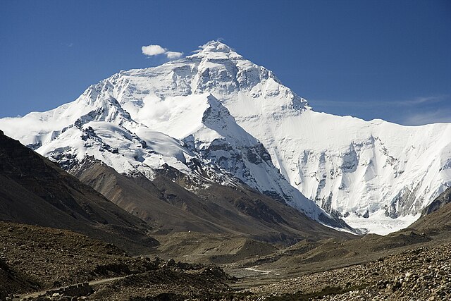
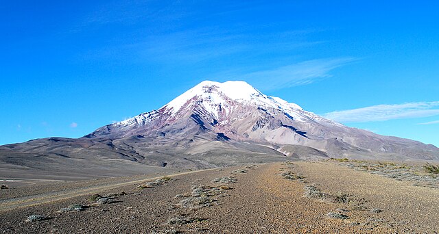
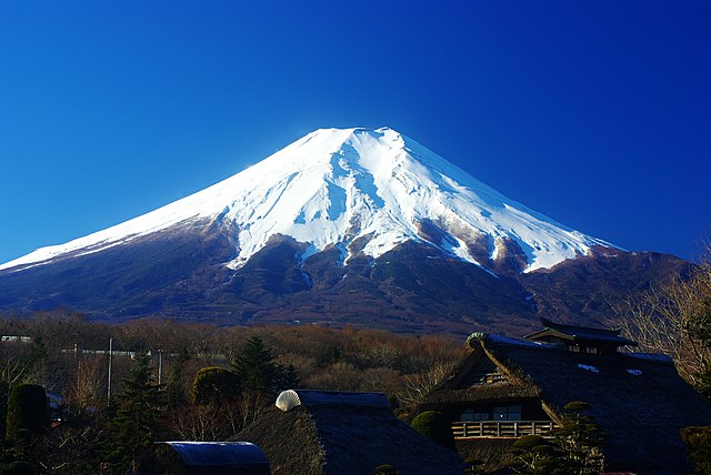
A mountain is a large landform that stretches above the surrounding land in a limited area, usually in the form of a peak. A mountain is steeper than a hill. Mountains are formed through tectonic forces or volcanism and these forces can locally raise the surface of the earth. Mountains erode slowly through the action of rivers, weather conditions, a few mountains are isolated summits, but most occur in huge mountain ranges. High elevations on mountains produce colder climates than at sea level and these colder climates strongly affect the ecosystems of mountains, different elevations have different plants and animals. Because of the less hospitable terrain and climate, mountains tend to be used less for agriculture and more for resource extraction and recreation, the highest mountain on Earth is Mount Everest in the Himalayas of Asia, whose summit is 8,850 m above mean sea level. The highest known mountain on any planet in the Solar System is Olympus Mons on Mars at 21,171 m, there is no universally accepted definition of a mountain. Elevation, volume, relief, steepness, spacing and continuity have been used as criteria for defining a mountain, whether a landform is called a mountain may depend on local usage. The highest point in San Francisco, California, is called Mount Davidson, notwithstanding its height of 300 m, similarly, Mount Scott outside Lawton, Oklahoma is only 251 m from its base to its highest point. Whittows Dictionary of Physical Geography states Some authorities regard eminences above 600 metres as mountains, in addition, some definitions also include a topographical prominence requirement, typically 100 or 500 feet. For a while, the US defined a mountain as being 1,000 feet or taller, any similar landform lower than this height was considered a hill. However, today, the United States Geological Survey concludes that these terms do not have technical definitions in the US, using these definitions, mountains cover 33% of Eurasia, 19% of South America, 24% of North America, and 14% of Africa. As a whole, 24% of the Earths land mass is mountainous, there are three main types of mountains, volcanic, fold, and block. All three types are formed from plate tectonics, when portions of the Earths crust move, crumple, compressional forces, isostatic uplift and intrusion of igneous matter forces surface rock upward, creating a landform higher than the surrounding features. The height of the feature makes it either a hill or, if higher and steeper, major mountains tend to occur in long linear arcs, indicating tectonic plate boundaries and activity. Volcanoes are formed when a plate is pushed below another plate, at a depth of around 100 km, melting occurs in rock above the slab, and forms magma that reaches the surface. When the magma reaches the surface, it builds a volcanic mountain. Examples of volcanoes include Mount Fuji in Japan and Mount Pinatubo in the Philippines, the magma does not have to reach the surface in order to create a mountain, magma that solidifies below ground can still form dome mountains, such as Navajo Mountain in the US
4.
Forest
–
A forest is a large area dominated by trees. Hundreds of more precise definitions of forest are used throughout the world, incorporating factors such as density, tree height, land use, legal standing. According to the widely used Food and Agriculture Organization definition, forests covered four billion hectares or approximately 30 percent of the land area in 2006. Forests are the dominant terrestrial ecosystem of Earth, and are distributed across the globe, Forests account for 75% of the gross primary productivity of the Earths biosphere, and contain 80% of the Earths plant biomass. Forests at different latitudes and elevations form distinctly different ecozones, boreal forests near the poles, tropical forests near the equator, higher elevation areas tend to support forests similar to those at higher latitudes, and amount of precipitation also affects forest composition. Human society and forests influence each other in both positive and negative ways, Forests provide ecosystem services to humans and serve as tourist attractions. Forests can also affect peoples health, human activities, including harvesting forest resources, can negatively affect forest ecosystems. Although forest is a term of common parlance, there is no universally recognised precise definition, there are three broad categories of forest definitions in use, administrative, land use, and land cover. Land use definitions are based upon the purpose that the land serves. For example, a forest may be defined as any land that is used primarily for production of timber, land cover definitions define forests based upon the type and density of vegetation growing on the land. Such definitions typically define a forest as an area growing trees above some threshold and these thresholds are typically the number of trees per area, the area of ground under the tree canopy or the section of land that is occupied by the cross-section of tree trunks. Under such land cover definitions, and area of land only be defined as forest if it is growing trees, areas that fail to meet the land cover definition may be still included under while immature trees are establishing if they are expected to meet the definition at maturity. Under land use definitions, there is variation on where the cutoff points are between a forest, woodland, and savanna. Under some definitions, forests require high levels of tree canopy cover, from 60% to 100%, excluding savannas. Other definitions consider savannas to be a type of forest, the term was not endemic to Romance languages, and cognates in Romance languages, such as Italian foresta, Spanish and Portuguese floresta, etc. are all ultimately borrowings of the French word. The exact origin of Medieval Latin foresta is obscure, uses of the word forest in English to denote any uninhabited area of non-enclosure are now considered archaic. The word was introduced by the Norman rulers of England as a term denoting an uncultivated area legally set aside for hunting by feudal nobility. These hunting forests were not necessarily wooded much, if at all, however, as hunting forests did often include considerable areas of woodland, the word forest eventually came to mean wooded land more generally
5.
Tundra
–
In physical geography, tundra is a type of biome where the tree growth is hindered by low temperatures and short growing seasons. The term tundra comes through Russian тундра from the Kildin Sami word tūndâr uplands, there are three types of tundra, Arctic tundra, alpine tundra, and Antarctic tundra. In tundra, the vegetation is composed of shrubs, sedges and grasses, mosses. Scattered trees grow in tundra regions. The ecotone between the tundra and the forest is known as the line or timberline. Arctic tundra occurs in the far Northern Hemisphere, north of the taiga belt, the word tundra usually refers only to the areas where the subsoil is permafrost, or permanently frozen soil. Permafrost tundra includes vast areas of northern Russia and Canada, the polar tundra is home to several peoples who are mostly nomadic reindeer herders, such as the Nganasan and Nenets in the permafrost area. Arctic tundra contains areas of landscape and is frozen for much of the year. The soil there is frozen from 25–90 cm down, and it is impossible for trees to grow, instead, bare and sometimes rocky land can only support low growing plants such as moss, heath, and lichen. There are two seasons, winter and summer, in the polar tundra areas. During the winter it is cold and dark, with the average temperature around −28 °C. However, extreme temperatures on the tundra do not drop as low as those experienced in taiga areas further south. During the summer, temperatures rise somewhat, and the top layer of seasonally-frozen soil melts, the tundra is covered in marshes, lakes, bogs and streams during the warm months. Generally daytime temperatures during the rise to about 12 °C. Arctic tundras are sometimes the subject of conservation programs. In Canada and Russia, many of areas are protected through a national Biodiversity Action Plan. Tundra tends to be windy, with winds often blowing upwards of 50–100 km/h, however, in terms of precipitation, it is desert-like, with only about 15–25 cm falling per year. Although precipitation is light, evaporation is also relatively minimal, there is a natural pattern of accumulation of fuel and wildfire which varies depending on the nature of vegetation and terrain
6.
Betula pubescens
–
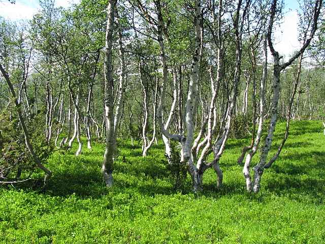
It is closely related to, and often confused with, the silver birch, but grows in wetter places with heavier soils and poorer drainage, smaller trees can also be confused with the dwarf birch. Three varieties are recognised and it hybridises with the silver and dwarf birches, a number of cultivars have been developed but many are no longer in cultivation. The larva of the moth feeds on the foliage and in some years. A large number of fungi are associated with the tree and certain pathogenic fungi are the agents of birch dieback disease. The tree is a species, readily colonising cleared land. The bark can be stripped off without killing the tree and the bark, the inner bark is edible and can be ground up and used in bread-making, as it still is at Easter in the traditional Finnish mämmi, or eaten in times of famine. The rising sap in spring is used to make refreshing drinks, wines, ales and liqueurs, Betula pubescens is commonly known as downy birch, with other common names including moor birch, white birch, European white birch or hairy birch. It is a tree growing to 10 to 20 m tall, with a slender crown. The shoots are grey-brown with fine downy, the leaves are ovate-acute,2 to 5 cm long and 1.5 to 4.5 cm broad, with a finely serrated margin. The flowers are wind-pollinated catkins, produced in spring before the leaves. B. pubescens is closely related to, and often confused with, many North American texts treat the two species as conspecific, but they are regarded as distinct species throughout Europe. Downy birch can be distinguished from silver birch with its smooth, downy shoots, the bark of the downy birch is a dull greyish white, whereas the silver birch has striking white, papery bark with black fissures. The leaf margins also differ, finely serrated in downy birch, the two have differences in habitat requirements, with downy birch more common on wet, poorly drained sites, such as clays and peat bogs, and silver birch found mainly on dry, sandy soils. In more northerly locations, downy birch can also be confused with the dwarf birch, all three species can be distinguished cytologically, silver birch and dwarf birch being diploid, whereas downy birch is tetraploid. In Iceland, dwarf birch and downy birch sometimes hybridise, the plants being triploid. Betula pubescens has a distribution in northern and central Europe. Its range extends from Newfoundland, Iceland, the British Isles and Spain eastwards across northern and central Europe, the range extends southwards to about 40°N, its southernmost limit being Turkey, the Caucasus and the Altai Mountains. It is a species which establishes itself readily in new areas away from the parent tree
7.
Trollheimen
–
Trollheimen is a mountain range in Møre og Romsdal and Sør-Trøndelag counties in central Norway. The mountain range is part of the Scandinavian Mountains, the name was proposed by Håkon Løken and used by Trondhjems Turistforening in the 1880s, and is considered a tourist name. Trollheimen is now the name in Norway for this mountain range. Trollheimen is often considered the most varied of all ranges in Norway for several reasons. The mountains in the part are alpine in form, with pointed peaks. The mountains in the east are less steep with more rounded shapes predominating, the climate differs from the more oceanic climate in the west to a considerably drier, continental climate in the eastern valleys, due to their being sheltered by mountains. The valleys in Trollheimen are at an altitude of only about 500 –800 m and are usually forested, there are also several large lakes, like Gjevilvatnet in the east, near Oppdal, and Gråsjøen and Foldsjøen in the northern part. The highest peaks are in the part, Trolla, Dronningkrona, Kongskrona, Såtbakkollen. In the northern and eastern part, the highest are Snota, Trollhetta, in the southeast there is Kråkvasstind. Trollheimen is known by botanists for the alpine flora, due to nutritient-rich soil. One of the alpine plants in Trollheimen is Artemisia norvegica. Approximately 1,160 km² of this area is declared a nature reserve, in the midst of the area is the Svartåmoen forest reserve, with undisturbed pine forest, mixed with birch. Innerdalen, in the part, was Norways first nature reserve. The Triangle is a route between the three mountain lodges each a long hike of some 7 –9 hours. It is possible to choose a route covering the three peaks of Trollhetta, a spectacular hike comparable to the Besseggen route in Jotunheimen, the hike to the peak of Snota is often considered one of the most beautiful in Norway. There are trout in most of the lakes, except in winter, Gjevilvasshytta can be reached by car, while Jøldalshytta is an easy 4 km hike from the nearest road. Trollheimshytta is a hike from any road, in the summer one can park by Gråsjøen. There are several smaller lodges as well, and many more marked routes
8.
Scandinavia
–
Scandinavia /ˌskændᵻˈneɪviə/ is a historical and cultural region in Northern Europe characterized by a common ethnocultural North Germanic heritage and mutually intelligible North Germanic languages. The term Scandinavia always includes the three kingdoms of Denmark, Norway and Sweden, the remote Norwegian islands of Svalbard and Jan Mayen are usually not seen as a part of Scandinavia, nor is Greenland, an overseas territory of Denmark. This looser definition almost equates to that of the Nordic countries, in Nordic languages, only Denmark, Norway and Sweden are commonly included in the definition of Scandinavia. In English usage, Scandinavia sometimes refers to the geographical area, the name Scandinavia originally referred vaguely to the formerly Danish, now Swedish, region Scania. Icelanders and the Faroese are to a significant extent descended from the Norse, Finland is mainly populated by Finns, with a minority of approximately 5% of Swedish speakers. A small minority of Sami people live in the north of Scandinavia. The Danish, Norwegian and Swedish languages form a continuum and are known as the Scandinavian languages—all of which are considered mutually intelligible with one another. Faroese and Icelandic, sometimes referred to as insular Scandinavian languages, are intelligible in continental Scandinavian languages only to a limited extent, Finnish and Meänkieli are closely related to each other and more distantly to the Sami languages, but are entirely unrelated to the Scandinavian languages. Apart from these, German, Yiddish and Romani are recognized minority languages in Scandinavia, the southern and by far most populous regions of Scandinavia have a temperate climate. Scandinavia extends north of the Arctic Circle, but has mild weather for its latitude due to the Gulf Stream. Much of the Scandinavian mountains have a tundra climate. There are many lakes and moraines, legacies of the last glacial period, Scandinavia usually refers to Denmark, Norway, and Sweden. Some sources argue for the inclusion of the Faroe Islands, Finland and Iceland, though that broader region is known by the countries concerned as Norden. Before this time, the term Scandinavia was familiar mainly to classical scholars through Pliny the Elders writings, and was used vaguely for Scania, as a political term, Scandinavia was first used by students agitating for Pan-Scandinavianism in the 1830s. After a visit to Sweden, Andersen became a supporter of early political Scandinavism, the term is often defined according to the conventions of the cultures that lay claim to the term in their own use. More precisely, and subject to no dispute, is that Finland is included in the broader term Nordic countries, various promotional agencies of the Nordic countries in the United States serve to promote market and tourism interests in the region. The official tourist boards of Scandinavia sometimes cooperate under one umbrella, Norways government entered one year later. All five Nordic governments participate in the joint promotional efforts in the United States through the Scandinavian Tourist Board of North America, Scandinavia can thus be considered a subset of the Nordic countries
9.
Tree line
–
The tree line is the edge of the habitat at which trees are capable of growing. It is found at high elevations and in frigid environments, beyond the tree line, trees cannot tolerate the environmental conditions. The tree line should not be confused with a lower timberline or forest line, at the tree line, tree growth is often sparse and stunted, with the last trees forming densely matted bushes, known as krummholz. The tree line, like other natural lines, appears well-defined from a distance. Trees grow shorter towards the inhospitable climate until they stop growing. The climate above the line of mountains is called an alpine climate. In the northern hemisphere treelines on north-facing slopes are lower than on south-facing slopes because the increased shade on north-facing slopes means the snowpack takes longer to melt and this shortens the growing season for trees. In the southern hemisphere, the slopes have the shorter growing season. The alpine tree line boundary is seldom abrupt, it forms a transition zone between closed forest below and treeless alpine tundra above. Environmentally dwarfed shrubs commonly forms the upper limit, the decrease in air temperature due to increasing elevation causes the alpine climate. Skin effects and topography can create microclimates that alter the general cooling trend, however, the number of degree days calculated from leaf temperatures may be very similar in the two kinds of timberlines. A series of warm summers in the 1940s seems to have permitted the establishment of “significant numbers” of spruce seedlings above the treeline in the hills near Fairbanks. Survival depends on a sufficiency of new growth to support the tree, the windiness of high-elevation sites is also a potent determinant of the distribution of tree growth. However, snow accumulation in sheltered gullies in the Selkirk Mountains of southeastern British Columbia causes timberline to be 400 metres lower than on exposed intervening shoulders. In a desert, the line marks the driest places where trees can grow. These tend to be called the tree line and occur below about 5,000 ft elevation in the Desert Southwestern United States. In some mountainous areas, higher elevations above the line or on equator-facing and leeward slopes can result in low rainfall. This dries out the soil, resulting in an arid environment unsuitable for trees
10.
Alpine tundra
–
Alpine tundra is a type of natural region or biome that does not contain trees because it is at high altitude. The high altitude causes an adverse climate, which is too cold, Alpine tundra transitions to sub-alpine forests below the tree line, stunted forests occurring at the forest-tundra ecotone are known as Krummholz. With increasing elevation it ends at the line where snow. Alpine tundra occurs in mountains worldwide, the flora of the alpine tundra is characterized by dwarf shrubs close to the ground. The cold climate of the tundra is caused by the lack of greenhouse effect at high altitude. Alpine tundra occurs at high altitude at any latitude. Portions of Montane grasslands and shrublands ecoregions worldwide include alpine tundra, Alpine tundra occupies high-mountain summits, slopes, and ridges above timberline. Aspect plays a role as well, the treeline often occurs at higher elevations on warmer equator-facing slopes, with limited access to infrastructure, only a handful of human communities exist in alpine zones. Many are small and have heavily specialized economies, often relying on such as agriculture, mining. An example of such a town is La Rinconada, Peru, a gold-mining town. A counterexample is El Alto, Bolivia, at 4,150 metres, which has a diverse service and manufacturing economy. Alpine climate is the weather for the alpine tundra. The climate becomes colder at high elevations—this characteristic is described by the rate of air, air tends to get colder as it rises. The dry adiabatic lapse rate is 10 °C per km of elevation or altitude, therefore, moving up 100 metres on a mountain is roughly equivalent to moving 80 kilometers towards the pole. This relationship is only approximate, however, since local factors such as proximity to oceans can drastically modify the climate, typical high-elevation growing seasons range from 45 to 90 days, with average summer temperatures near 10 °C. Growing season temperatures frequently fall below freezing, and frost occurs throughout the season in many areas. Precipitation occurs mainly as snow, but soil water availability is highly variable with season, location. For example, snowfields commonly accumulate on the lee sides of ridges while ridgelines may remain nearly snow free due to redistribution by wind, some alpine habitats may be up to 70% snow free in winter
11.
Perennial plant
–
A perennial plant or simply perennial is a plant that lives for more than two years. The term is used to differentiate a plant from shorter-lived annuals and biennials. The term is widely used to distinguish plants with little or no woody growth from trees and shrubs. Tomato vines, for example, live several years in their natural habitat but are grown as annuals in temperate regions because they dont survive the winter. There is also a class of evergreen, or non-herbaceous, perennials, an intermediate class of plants is known as subshrubs, which retain a vestigial woody structure in winter, e. g. Penstemon. The local climate may dictate whether plants are treated as shrubs or perennials, for instance, many varieties of Fuchsia are shrubs in warm regions, but in colder temperate climates may be cut to the ground every year as a result of winter frosts. The symbol for a plant, based on Species Plantarum by Linnaeus, is. Perennial plants can be short-lived or they can be long-lived, as are some plants like trees. They include an assortment of plant groups from ferns and liverworts to the highly diverse flowering plants like orchids. Plants that flower and fruit only once and then die are termed monocarpic or semelparous, however, most perennials are polycarpic, flowering over many seasons in their lifetime. Perennials typically grow structures that allow them to adapt to living one year to the next through a form of vegetative reproduction rather than seeding. These structures include bulbs, tubers, woody crowns, rhizomes plus others and they might have specialized stems or crowns that allow them to survive periods of dormancy over cold or dry seasons during the year. Many perennials have developed specialized features that allow them to extreme climatic. Some have adapted to hot and dry conditions or cold temperatures. Those plants tend to invest a lot of resource into their adaptations and often do not flower, Many perennials produce relatively large seeds, which can have an advantage, with larger seedlings produced after germination that can better compete with other plants. Some annuals produce many seeds per plant in one season, while some perennials are not under the same pressure to produce large numbers of seeds. In warmer and more favorable climates, perennials grow continuously, in seasonal climates, their growth is limited to the growing season. In some species, perennials retain their foliage all year round, other plants are deciduous perennials, for example, in temperate regions a perennial plant may grow and bloom during the warm part of the year, with the foliage dying back in the winter
12.
Cyperaceae
–
The Cyperaceae are a family of monocotyledonous graminoid flowering plants known as sedges, which superficially resemble grasses and rushes. The family is large, with some 5,500 known species described in about 90 genera and these species are widely distributed, with the centers of diversity for the group occurring in tropical Asia and tropical South America. While sedges may be growing in almost all environments, many are associated with wetlands. Ecological communities dominated by sedges are known as sedgelands, features distinguishing members of the sedge family from grasses or rushes are stems with triangular cross-sections and leaves that are spirally arranged in three ranks. Some well-known sedges include the chestnut and the papyrus sedge. This family also includes cotton-grass, spike-rush, sawgrass, nutsedge or nutgrass, and white star sedge