Morrissey Boulevard
Videos
Morrissey Boulevard is a six-lane divided coastal road in the Dorchester neighborhood of Boston, Massachusetts, United States. It is owned and maintained by the Massachusetts Department of Conservatio

Aerial view of Morrissey Boulevard and UMass Boston in September 1993.

Aerial view of the National Grid gas tank, the I-93/US-1/MA-3 concurrency, and Morrissey Boulevard with the Beades Bridge visible in September 2010.

Morrissey Boulevard and UMass Boston from the highway concurrency in Dorchester in April 2014.

Aerial view of the JFK/UMass station in July 2019 with Morrissey Boulevard's intersections with Old Colony Avenue and Mount Vernon Street and with Kosciuszko Circle visible in top right.
Columbia Point, Boston
Videos
Columbia Point, in the Dorchester neighborhood of Boston, Massachusetts, sits on a peninsula jutting out from the mainland of eastern Dorchester into the bay. Old Harbor Park is on the north side, adj
Morrissey Boulevard
…in its northernmost stretch beyond Savin Hill. The road ends as it intersects Columbia Road and Day Boulevard at Kosciuszko Circle, adjacent to the Columbia Point section of Dorchester and JFK/UMass subway and commuter rail station. The road was designed as early as 1906 as an urban parkway to be constructed along…

Columbia Point housing from Carson Beach. The photo depicts a 1977 racial conflict between residents of Columbia Point and South Boston for the use of Carson Beach and the L Street bath house.
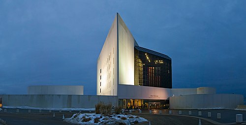
John F. Kennedy Presidential Library and Museum on the Columbia Point peninsula

View of Old Harbor at Columbia Point.

U Mass Boston campus