Motobu Peninsula
Videos
Photos
The Motobu Peninsula is a peninsula in the Yanbaru region of Okinawa Island. It is surrounded by Nago Bay to the east, the Haneda Inland Sea to the north, and the East China Sea to the west. It is mostly mountainous, with a few plains. The peninsula's northeasternmost point is Cape Bise. Its highest point is Mount Yae, whose summit is 593 metres (1,946 ft). Due to a US military communications tower, the summit is off-limits. The peninsula was the center of power for the kingdom of Hokuzan in medieval times, and was the site of fierce fighting during the Battle of Okinawa in 1945.

View of the Motobu Peninsula from Onna, Okinawa

Cape Bise
Okinawa Island
Videos
Photos
Okinawa Island , officially Okinawa Main Island , is the largest of the Okinawa Islands and the Ryukyu (Nansei) Islands of Japan in the Kyushu region. It is the smallest and least populated of the five main islands of Japan. The island is approximately 106 kilometres (66 mi) long, an average 11 kilometres (7 mi) wide, and has an area of 1,206.98 square kilometers (466.02 sq mi). It is roughly 640 kilometres south of the main island of Kyushu and the rest of Japan. It is 500 km northeast of Taiwan. The total population of Okinawa Island is 1,384,762. The greater Naha area has roughly 800,000 residents, while the city itself has about 320,000 people. Naha is the seat of Okinawa Prefecture on the southwestern part of Okinawa Island. Okinawa has a humid subtropical climate.
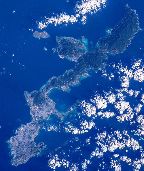
Okinawa Island in 2015

The first of the Ryukyuan missions to Edo, the capital of Tokugawa shogunate

The last King Shō Tai

American troops in Okinawa, 27 June 1945