Mumrills was the site of the largest Roman fort on the Antonine Wall in Scotland. It is possible that Mumrills could exchange signals with Flavian Gask Ridge forts. Some believe Mumrills may have been the site of Wallace's defeat at the Battle of Falkirk. The farm at Mumrills was also used as an early site for the Falkirk Relief Church.
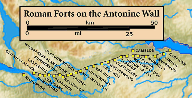
Forts and Fortlets associated with the Antonine Wall from west to east: Bishopton, Old Kilpatrick, Duntocher, Cleddans, Castlehill, Bearsden, Summerston, Balmuildy, Wilderness Plantation, Cadder, Glasgow Bridge, Kirkintilloch, Auchendavy, Bar Hill, Croy Hill, Westerwood, Castlecary, Seabegs, Rough Castle, Camelon, Watling Lodge, Falkirk, Mumrills, Inveravon, Kinneil, Carriden
Site of the Antonine Wall near Mumrills Road
There is evidence to show that Mumrills had lilia pits like those that can still be seen at Roughcastle.
Sketch plan of kiln at Mumrills, by Mungo Buchanan from the Proceedings Of The Society Of Antiquaries Of Scotland (1914-1915) Vol 49
The Antonine Wall was a turf fortification on stone foundations, built by the Romans across what is now the Central Belt of Scotland, between the Firth of Clyde and the Firth of Forth. Built some twenty years after Hadrian's Wall to the south, and intended to supersede it, while it was garrisoned it was the northernmost frontier barrier of the Roman Empire. It spanned approximately 63 kilometres and was about 3 metres high and 5 metres wide. Lidar scans have been carried out to establish the length of the wall and the Roman distance units used. Security was bolstered by a deep ditch on the northern side. It is thought that there was a wooden palisade on top of the turf. The barrier was the second of two "great walls" created by the Romans in Great Britain in the second century AD. Its ruins are less evident than those of the better-known and longer Hadrian's Wall to the south, primarily because the turf and wood wall has largely weathered away, unlike its stone-built southern predecessor.
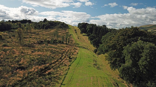
Antonine Wall near Bar Hill showing ditch
Stone foundation of the Wall in Bearsden, Glasgow
Forts and Fortlets associated with the Antonine Wall from west to east: Bishopton, Old Kilpatrick, Duntocher, Cleddans, Castlehill, Bearsden, Summerston, Balmuildy, Wilderness Plantation, Cadder, Glasgow Bridge, Kirkintilloch, Auchendavy, Bar Hill, Croy Hill, Westerwood, Castlecary, Seabegs, Rough Castle, Camelon, Watling Lodge, Falkirk, Mumrills, Inveravon, Kinneil, Carriden
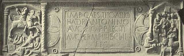
The Bridgeness Slab – the easternmost distance slab