Nelson Province
Videos
Photos
Nelson Province was constituted in 1853 under the New Zealand Constitution Act 1852, and originally covered the entire upper South Island, including all of present-day Buller, Kaikoura, Marlborough, and Tasman districts, along with Nelson City, Grey District north of the Grey River, and the Hurunui District north of the Hurunui River. It was reduced in size by the creation of Marlborough Province in November 1859, then abolished in 1876, along with all the provinces of New Zealand.

Nelson Provincial Council buildings

Model of the Nelson Provincial Government building on display in the Nelson Provincial Museum (building existed 1859–1969)
South Island
Videos
Photos
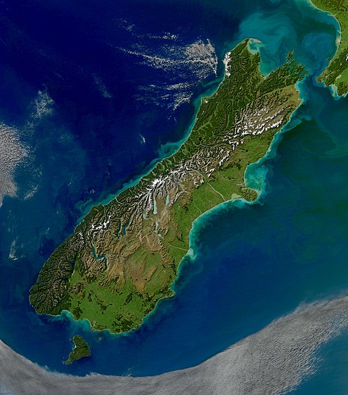
The South Island, also named Te Waipounamu in Māori, is the larger of the two major islands of New Zealand in surface area, the other being the smaller but more populous North Island. It is bordered to the north by Cook Strait, to the west by the Tasman Sea, and to the south and east by the Pacific Ocean. The South Island covers 150,437 square kilometres (58,084 sq mi), making it the world's 12th-largest island, constituting 56% of New Zealand's land area. At low altitude, it has an oceanic climate.
South Island

Charcoal rock drawing at Carters rockpool on the Ōpihi River

First European impression of Māori, at Murderers' Bay, 1642

Ships in what is likely to be Akaroa Harbour some time in the early 19th century