New York Harbor
Videos
New York Harbor is at the mouth of the Hudson River where it empties into New York Bay near the East River tidal estuary, and then into the Atlantic Ocean on the East Coast of the United States.

Upper New York Bay highlighted in red. It is connected to Lower New York Bay on the south by the Narrows. Ellis Island (north) and Liberty Island (south) are shown in the northwest corner of the bay.

New York Harbor and Upper New York Bay (right), Hudson River (lower left), and East River (upper left) in April 2013

Wallabout Bay and East River (foreground), Hudson River (at right), Upper New York Bay (left) and Newark Bay in the distance in April 1981
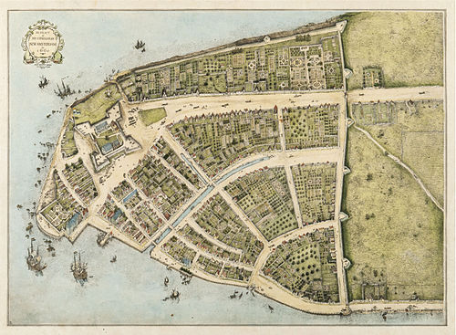
New Amsterdam, 1660: early East River docks along left bottom; protective wall against the British on right. West is at top. (Castello Plan redraft)
Hudson River
Videos
The Hudson River is a 315-mile (507 km) river that flows from north to south primarily through eastern New York, United States. It originates in the Adirondack Mountains of upstate New York at Henderson Lake in the town of Newcomb, and flows southward through the Hudson Valley to the New York Harbor between New York City and Jersey City, eventually draining into the Atlantic Ocean at Upper New York Bay. The river serves as a physical boundary between the states of New Jersey and New York at its southern end. Farther north, it marks local boundaries between several New York counties. The lower half of the river is a tidal estuary, deeper than the body of water into which it flows, occupying the Hudson Fjord, an inlet that formed during the most recent period of North American glaciation, estimated at 26,000 to 13,300 years ago. Even as far north as the city of Troy, the flow of the river changes direction with the tides.

Bear Mountain Bridge across the Hudson River as seen from Bear Mountain in New York state

The Hudson River flowing out of Henderson Lake in Tahawus

The river from Poughkeepsie, looking north.

The river between Hudson Waterfront in New Jersey (left) and Manhattan (right)