Niagara River
Videos
The Niagara River flows north from Lake Erie to Lake Ontario, forming part of the border between Ontario, Canada, to the west, and New York, United States, to the east. The origin of the river's name is debated. Iroquoian scholar Bruce Trigger suggests it is derived from a branch of the local Neutral Confederacy, referred to as the Niagagarega people on several late-17th-century French maps. George R. Stewart posits that it comes from an Iroquois town named Ongniaahra, meaning "point of land cut in two."

The Niagara River at Niagara Gorge in May 2008

Satellite image of Niagara River flowing north from Lake Erie (bottom) to Lake Ontario (top). The river flows around Grand Island, and then flows over Niagara Falls. It narrows in the Niagara Gorge, where two hydropower reservoirs are visible, and then widens after exiting the gorge. The Welland Canal is visible on the far left.

American Falls with Goat Island to its right

Niagara River at Queenston, Ontario, then known as Queenstown, Upper Canada, c. 1805 watercolour
Niagara Falls
Videos
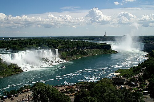
Niagara Falls is a group of three waterfalls at the southern end of Niagara Gorge, spanning the border between the province of Ontario in Canada and the state of New York in the United States. The largest of the three is Horseshoe Falls, which straddles the international border of the two countries. It is also known as the Canadian Falls. The smaller American Falls and Bridal Veil Falls lie within the United States. Bridal Veil Falls is separated from Horseshoe Falls by Goat Island and from American Falls by Luna Island, with both islands situated in New York.

Canadian Horseshoe Falls at right

Damage from wind and ice on Goat Island, 1903

American and Bridal Falls diverted during erosion control efforts in 1969