Nilosyrtis Mensae is an area of Mars in the Casius quadrangle. It is centered on the coordinates of 36.87° N and 67.9° E. Its western and eastern longitudes are 51.1° E and 74.4° E. North and south latitudes are 36.87° N and 29.61° N. Nilosyrtis Mensae is just to the east of Protonilus Mensae and both lie along the Martian dichotomy boundary. Its name was adapted by the IAU in 1973. It was named after a classical albedo feature, and it is 705 km (438 mi) across.
Astapus Colles Mounds and Knobs, as seen by HiRISE. Scale bar is 500 meters long.
Inverted crater mesa, Nilosyrtis Mensae. This is thought to be an old impact crater that was eroded, filled in and then eroded again, so that now it is a low mesa surrounded by a bouldery slope. Image is about 900 m wide.
Bedrock in Nilosyrtis Mensae. Image is about 1.5 km wide. In this enhanced-color image, the blue and green colors are generally due to mafic (magnesium and iron rich) minerals that are not altered by water, while the warmer colors are due to altered minerals like clays. The structure in this scene is complex, from impact and perhaps fluvial and volcanic processes, tectonic faulting, and erosion. This is an old terrain with a complex geologic history.
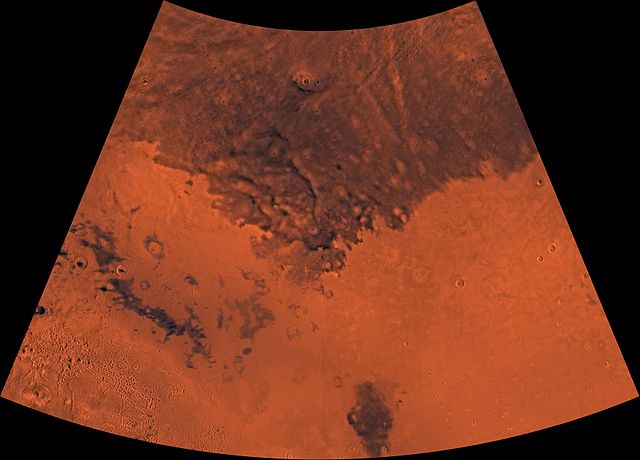
The Casius quadrangle is one of a series of 30 quadrangle maps of Mars used by the United States Geological Survey (USGS) Astrogeology Research Program. The quadrangle is located in the north-central portion of Mars' eastern hemisphere and covers 60° to 120° east longitude and 30° to 65° north latitude. The quadrangle uses a Lambert conformal conic projection at a nominal scale of 1:5,000,000 (1:5M). The Casius quadrangle is also referred to as MC-6. Casius quadrangle contains part of Utopia Planitia and a small part of Terra Sabaea.
The southern and northern borders of the Casius quadrangle are approximately 3,065 km and 1,500 km wide, respectively. The north to south distance is about 2,050 km. The quadrangle covers an approximate area of 4.9 million square km, or a little over 3% of Mars' surface area.
The Casius Quadrangle (MC-6). The southwest contains Nilosyrtis Mensae (faults, measa and buttes). The rest is mostly smooth plains.
Patterned ground in the form of polygonal features is associated with ground ice. It is rare to be found this far south (45 degrees north latitude). Picture taken by Mars Global Surveyor.
Field of low center polygons near crater, as seen by HiRISE under HiWish program. These features are common where the ground freezes and thaws.
Periglacial Forms in Utopia, as seen by HiRISE. Click on image to see patterned ground and scalloped topography.