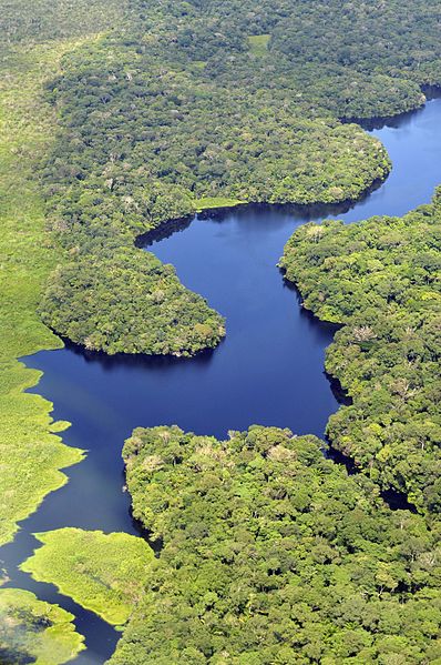
Amazon River
The Amazon River in South America is the largest river by discharge volume of water in the world, by some definitions it is the longest. The headwaters of the Apurímac River on Nevado Mismi had been considered for nearly a century as the Amazon's most distant source, until a 2014 study found it to be the headwaters of the Mantaro River on the Cordillera Rumi Cruz in Peru; the Mantaro and Apurímac join, with other tributaries form the Ucayali River, which in turn meets the Marañón River upstream of Iquitos, Peru, to form what countries other than Brazil consider to be the main stem of the Amazon. Brazilians call this section the Solimões River above its confluence with the Rio Negro to form what Brazilians call the Amazon at the Meeting of Waters at Manaus, the river's largest city. At an average discharge of about 209,000 cubic metres per second —approximately 6,591 cubic kilometres per annum, greater than the next seven largest independent rivers combined—the Amazon represents 20% of the global riverine discharge to the ocean.
The Amazon basin is the largest drainage basin in the world, with an area of 7,050,000 square kilometres. The portion of the river's drainage basin in Brazil alone is larger than any other river's basin; the Amazon enters Brazil with only one-fifth of the flow it discharges into the Atlantic Ocean, yet has a greater flow at this point than the discharge of any other river. The river was known by Europeans as the Marañón and the Peruvian part of the river is still known by that name today, it became known as the Rio Amazonas in Spanish and Portuguese, or The Amazon in English. The name Rio Amazonas was given after native warriors attacked a 16th-century expedition by Francisco de Orellana; the warriors were led by women, reminding de Orellana of the Amazon warriors, a tribe of women warriors related to Iranian Scythians and Sarmatians mentioned in Greek mythology. The word Amazon itself may be derived from the Iranian compound *ha-maz-an- " fighting together" or ethnonym *ha-mazan- "warriors", a word attested indirectly through a derivation, a denominal verb in Hesychius of Alexandria's gloss "ἁμαζακάραν· πολεμεῖν.
Πέρσαι", where it appears together with the Indo-Iranian root *kar- "make". During what many archaeologists call the formative stage, Amazonian societies were involved in the emergence of South America's highland agrarian systems; the trade with Andean civilisations in the terrains of the headwaters in the Andes, formed an essential contribution to the social and religious development of the higher altitude civilisations of among others the Muisca and Incas. Early human settlements were based on low-lying hills or mounds. Shell mounds were the earliest evidence of habitation, they are associated with ceramic age cultures. Artificial earth platforms for entire villages are the second type of mounds, they are best represented by the Marajoara culture. Figurative mounds are the most recent types of occupation. There is ample evidence that the areas surrounding the Amazon River were home to complex and large-scale indigenous societies chiefdoms who developed large towns and cities. Archaeologists estimate that by the time the Spanish conquistador De Orellana traveled across the Amazon in 1541, more than 3 million indigenous people lived around the Amazon.
These pre-Columbian settlements created developed civilizations. For instance, pre-Columbian indigenous people on the island of Marajó may have developed social stratification and supported a population of 100,000 people. In order to achieve this level of development, the indigenous inhabitants of the Amazon rainforest altered the forest's ecology by selective cultivation and the use of fire. Scientists argue that by burning areas of the forest repetitiously, the indigenous people caused the soil to become richer in nutrients; this created dark soil areas known as terra preta de índio. Because of the terra preta, indigenous communities were able to make land fertile and thus sustainable for the large-scale agriculture needed to support their large populations and complex social structures. Further research has hypothesized; some say that its effects on forest ecology and regional climate explain the otherwise inexplicable band of lower rainfall through the Amazon basin. Many indigenous tribes engaged in constant warfare.
James Stuart Olson wrote: "The Munduruku expansion dislocated and displaced the Kawahíb, breaking the tribe down into much smaller groups... first came to the attention of Europeans in 1770 when they began a series of widespread attacks on Brazilian settlements along the Amazon River." In March 1500, Spanish conquistador Vicente Yáñez Pinzón was the first documented European to sail up the Amazon River. Pinzón called the stream Río Santa María del Mar Dulce shortened to Mar Dulce sweet sea, because of its fresh water pushing out into the ocean. Another Spanish explorer, Francisco de Orellana, was the first European to travel from the origins of the upstream river basins, situated in the Andes, to the mouth of the river. In this journey, Orellana baptised some of the affluents of the Amazonas like Rio Negro and Jurua; the name Amazonas is taken from the native warriors that attacked this expedition women, that reminded De Orellana of the mythical female Amazon warriors from the
Tocantins
Tocantins is one of the states of Brazil.. It is the newest of the 26 Brazilian states, formed in 1988 and encompassing what had been the northern two-fifths of the state of Goiás. Tocantins covers 277,620.91 square kilometres and has a population of 1,496,880. Construction of its capital, began in 1989. With the exception of Araguaína there are few other cities with a significant population in the state; the government has invested in a new capital, a major hydropower dam and related infrastructure to develop this agricultural area. Tocantins has attracted hundreds of thousands of new residents to Palmas, it is building on its hydropower resources. The Araguaia and Tocantins rivers drain the largest watershed that lies inside Brazilian territory; the Rio Tocantins has been dammed for hydropower, creating a large reservoir that has become a center of recreation. Because it is in the central zone of the country, Tocantins has characteristics of the Amazon Basin, semi-open pastures, known as cerrado.
The Bananal Island, in the southwest of the State, is the largest fluvial island in the world. Tocantins is home to the Araguaia National Park, the Carajás Indian reservations, Jalapão State Park, about 250 kilometres from Palmas. There, the rivers create oases in the dry landscape. Tocantins geography is varied, it straddles both the coastal savanna. Many rivers traverse the state. Researchers have identified more than 20 archaeologically significant sites related to indigenous cultures. Tocantins is bordered to the northeast by the states of Maranhão and Piauí, Bahia to the east, Goiás to the south, Mato Grosso to the west, Pará to the northwest. Tocantins was created from the northern two-fifths of Goiás state in 1989 and is divided into 139 municipalities. Following its detachment from Goiás, the new state was transferred from Brazil's Central-West Region to the North Region. Most of Tocantins is situated within a vast Brazilian area known as the cerrado; the cerrado region's typical climate is hot and semi-humid, with pronounced seasonal variation marked by a dry winter from May through October.
The annual rainfall is around 800 to 1600 mm. The "cerrado" landscape cover 87% of Tocantins and is characterized by extensive savanna formations crossed by gallery forests and stream valleys. Cerrado includes various types of vegetation. Humid fields and "buriti" palm paths are found. Alpine pastures occur at mesophytic forests on more fertile soils. In the north of Tocantins the cerrado gives place to a zone of transition for the Amazon biome, near Tocantins River; the savanna formations are not homogenous. There is great variation between the amount of woody and herbaceous vegetation, forming a gradient from open "cerrado" — open fields dominated by grasses — to the closed, forest-like "cerrado" and the "cerradão", a closed canopy forest. Intermediate forms include the dirty field, the "cerrado" field, the "cerrado" sensu stricto, according to a growing density of trees; the "cerrado" trees have characteristic twisted trunks covered by a thick bark, leaves that are broad and rigid. Many herbaceous plants have extensive roots to store water and nutrients.
The plant's thick bark and roots serve as adaptations for the periodic fires which sweep the cerrado landscape. The adaptations protect the plants from destruction and make them capable of sprouting again after the fire; as in many savannas in the world, the "cerrado" ecosystems have been coexisting with fire since ancient times. They developed adaptations to natural fires caused by lightning or volcanic activity, to those caused by man. Along the western boundary of the state is the floodplain of the Araguaia River, which includes extensive wetlands and Amazon tropical forest ecosystems. Bananal Island, formed by two branches of the Araguaia, is said to be the largest river island in the world, it consists of marshlands and seasonally flooded savannas, with gallery forest. Where the two branches meet again they form an inland delta called Cantão, a typical Amazonian igapó flooded forest; the Araguaia is one of the main links between the Amazonian lowlands and the Pantanal wetlands to the south, but the river is not navigable.
Portuguese Jesuit missionaries explored what is today Tocantins state about 1625, seeking to convert the Amerindian peoples of the area to Christianity. The area is named after the Tocantins River. Before 1988 the area made up the northern one-third of Goiás state. Since the 17th century, this area was isolated by rivers navigable only in short portions and mountains, difficult to access; as a result, the southern area of the state became more developed after this area was selected in 1956 as the site for the development of the new capital of Brasília and the Federal District. A strong separatist movement developed in the north for independence of its people. After the government levied heavy taxes on mining in 1809, local residents began to organize a separatists movement, they made a minor revolt, crushed by the army. In the 19th century, a string of failed uprisings occurred in the north; the area was
Gonzalo Fernández de Oviedo y Valdés
Gonzalo Fernández de Oviedo y Valdés was a Spanish historian and writer. He is known as "Oviedo" though his family name is Fernández, he participated in the Spanish colonization of the Caribbean, wrote a long chronicle of this project, one of the few primary sources about it. For three centuries, only a small portion of it was published, read in the 16th century in Spanish and French editions, he was born in Madrid of a noble Asturian lineage and educated in the court of Ferdinand and Isabella. At thirteen, he became page to the Infante John, Prince of Asturias. After the Prince's death, Oviedo went to Italy, there acted as secretary to Gonzalo Fernández de Córdoba. In 1514 he was appointed supervisor of gold smeltings at Santo Domingo, on his return to Spain in 1523 was appointed historiographer of the Indies, he paid five more visits to America before his death, in Valladolid in 1557. At one point he was placed in charge of the Fortaleza Ozama, the famous fort in Santo Domingo, Dominican Republic, where there is a large statue of him, a gift to that country from a King of Spain.
Oviedo's first literary work was a chivalric romance entitled, Libro del muy esforzado e invencible caballero Don Claribalte. It was published in 1519 in Valencia by one of the prominent printers of that time. In the foreword, dedicated to Ferdinand of Aragón, Duke of Calabria, Oviedo relates that the work had been conceived and written while he was in Santo Domingo. Therefore, it seems. Oviedo wrote two extensive works of permanent value, which for the most part were not published until three centuries after his death: La historia general y natural de las Indias and Las Quinquagenas de la nobleza de España; the former work was first issued at Toledo in the form of a summary entitled La Natural hystoria de las Indias. A. de los Rios for the Spanish Academy of History. The Quinquagenas is a collection of quaint, moralizing anecdotes in which Oviedo indulges in much lively gossip concerning eminent contemporaries, it was first published at Madrid in 1880, edited by Vicente de la Fuente. The Historia, though written in a diffuse style, furnishes a mass of information collected at first hand.
Las Casas, the fellow contemporary chronicler of the Spanish colonization of the Caribbean, denounced Oviedo and the Historia thus: "one of the greatest tyrants and destroyers of the Indies, whose Historia contains as many lies as pages". The incomplete Seville edition was read in the English and French versions published by Eden and Poleur in 1555 and 1556, it is through Oviedo's book that Europeans came to learn about the hammock, the pineapple, tobacco, among other things used by the Native Americans that he encountered. The first illustration of a pineapple is credited to him. Shortly after Columbus was in Hispaniola, Oviedo visited there and saw the natives using green wooden stakes lashed to a frame over a smouldering fire for cooking; the Taino word for this device was "barbacoa". There were other changes to the word including the French "Boucane". Liévano Aguirre, Indalecio. 2002. Los grandes conflictos sociales y económicos de nuestra historia. Volumes 3-4. Bogotá: Intermedio. Spanish Wikipedia article on Libro de Claribalte
Pre-Columbian era
The Pre-Columbian era incorporates all period subdivisions in the history and prehistory of the Americas before the appearance of significant European influences on the American continent, spanning the time of the original settlement in the Upper Paleolithic period to European colonization during the Early Modern period. While the phrase "pre-Columbian era" refers only to the time preceding Christopher Columbus's voyages of 1492, in practice the phrase is used to denote the entire history of indigenous Americas cultures until those cultures were exterminated, diminished, or extensively altered by Europeans if this happened decades or centuries after Columbus's first landing. For this reason the alternative terms of Precontact Americas, Pre-Colonial Americas or Prehistoric Americas are in use. In areas of Latin America the term used is Pre-Hispanic. Many pre-Columbian civilizations established hallmarks which included permanent settlements, agriculture and monumental architecture, major earthworks, complex societal hierarchies.
Some of these civilizations had long faded by the time of the first permanent European colonies and the arrival of enslaved Africans, are known only through archaeological investigations and oral history. Other civilizations were contemporary with the colonial period and were described in European historical accounts of the time. A few, such as the Maya civilization, had their own written records; because many Christian Europeans of the time viewed such texts as heretical, men like Diego de Landa destroyed many texts in pyres while seeking to preserve native histories. Only a few hidden documents have survived in their original languages, while others were transcribed or dictated into Spanish, giving modern historians glimpses of ancient culture and knowledge. Indigenous American cultures continue to evolve after the pre-Columbian era. Many of these peoples and their descendants continue traditional practices while evolving and adapting new cultural practices and technologies into their lives.
Before the development of archaeology in the 19th century, historians of the pre-Columbian period interpreted the records of the European conquerors and the accounts of early European travelers and antiquaries. It was not until the nineteenth century that the work of men such as John Lloyd Stephens, Eduard Seler and Alfred P. Maudslay, of institutions such as the Peabody Museum of Archaeology and Ethnology of Harvard University, led to the reconsideration and criticism of the European sources. Now, the scholarly study of pre-Columbian cultures is most based on scientific and multidisciplinary methodologies. Asian nomads are thought to have entered the Americas via the Bering Land Bridge, now the Bering Strait and along the coast. Genetic evidence found in Amerindians' maternally inherited mitochondrial DNA supports the theory of multiple genetic populations migrating from Asia. Over the course of millennia, Paleo-Indians spread throughout South America; when the first group of people migrated into the Americas is the subject of much debate.
One of the earliest identifiable cultures was the Clovis culture, with sites dating from some 13,000 years ago. However, older sites dating back to 20,000 years ago have been claimed; some genetic studies estimate the colonization of the Americas dates from between 40,000 and 13,000 years ago. The chronology of migration models is divided into two general approaches; the first is the short chronology theory with the first movement beyond Alaska into the Americas occurring no earlier than 14,000–17,000 years ago, followed by successive waves of immigrants. The second belief is the long chronology theory, which proposes that the first group of people entered the hemisphere at a much earlier date 50,000–40,000 years ago or earlier. Artifacts have been found in both North and South America which have been dated to 14,000 years ago, accordingly humans have been proposed to have reached Cape Horn at the southern tip of South America by this time. In that case, the Eskimo peoples would have arrived separately and at a much date no more than 2,000 years ago, moving across the ice from Siberia into Alaska.
The North American climate was unstable. It stabilized by about 10,000 years ago. Within this time frame pertaining to the Archaic Period, numerous archaeological cultures have been identified; the unstable climate led to widespread migration, with early Paleo-Indians soon spreading throughout the Americas, diversifying into many hundreds of culturally distinct tribes. The Paleo-Indians were hunter-gatherers characterized by small, mobile bands consisting of 20 to 50 members of an extended family; these groups moved from place to place as preferred resources were depleted and new supplies were sought. During much of the Paleo-Indian period, bands are thought to have subsisted through hunting now-extinct giant land animals such as mastodon and ancient bison. Paleo-Indian groups carried a variety of tools; these included distinctive projectile points and knives, as well as less distinctive implements used for butchering and hide processing. The vastness of the North American continent, the variety of its climates, vegetation and landforms, led ancient peoples to coalesce into many distinct linguistic and cultural groups.
This is reflected in the oral histories of the indigenous peoples, described by a wide range of traditional creation stories which say that a given people have been living in a certain territory since the creation of the world. Over the course of thousands of years, paleo-Indian
Literacy
Dictionaries traditionally define literacy as the ability to read and write. In the modern world, this is one way of interpreting literacy. One more broad interpretation sees literacy as competence in a specific area; the concept of literacy has evolved in meaning. The modern term's meaning has been expanded to include the ability to use language, images and other basic means to understand, gain useful knowledge, solve mathematical problems and use the dominant symbol systems of a culture; the concept of literacy is expanding across OECD countries to include skills to access knowledge through technology and ability to assess complex contexts. A person who travels and resides in a foreign country but is unable to read or write in the language of the host country would be regarded by the locals as illiterate; the key to literacy is reading development, a progression of skills which begins with the ability to understand spoken words and decode written words, which culminates in the deep understanding of text.
Reading development involves a range of complex language-underpinnings including awareness of speech sounds, spelling patterns, word meaning and patterns of word formation, all of which provide a necessary platform for reading fluency and comprehension. Once these skills are acquired, a reader can attain full language literacy, which includes the abilities to apply to printed material critical analysis and synthesis; the inability to do so is called "illiteracy" or "analphabetism". Experts at a United Nations Educational and Cultural Organization meeting have proposed defining literacy as the "ability to identify, interpret, create and compute, using printed and written materials associated with varying contexts"; the experts note: "Literacy involves a continuum of learning in enabling individuals to achieve their goals, to develop their knowledge and potential, to participate in their community and wider society". Literacy emerged with the development of numeracy and computational devices as early as 8000 BCE.
Script developed independently at least five times in human history Mesopotamia, the Indus civilization, lowland Mesoamerica, China. The earliest forms of written communication originated in Serbia, followed by Sumer, located in southern Mesopotamia about 3500-3000 BCE. During this era, literacy was "a functional matter, propelled by the need to manage the new quantities of information and the new type of governance created by trade and large scale production". Writing systems in Mesopotamia first emerged from a recording system in which people used impressed token markings to manage trade and agricultural production; the token system served as a precursor to early cuneiform writing once people began recording information on clay tablets. Proto-cuneiform texts exhibit not only numerical signs, but ideograms depicting objects being counted. Egyptian hieroglyphs emerged from 3300-3100 BCE and depicted royal iconography that emphasized power amongst other elites; the Egyptian hieroglyphic writing system was the first notation system to have phonetic values.
Writing in lowland Mesoamerica was first put into practice by the Olmec and Zapotec civilizations in 900-400 BCE. These civilizations used glyphic writing and bar-and-dot numerical notation systems for purposes related to royal iconography and calendar systems; the earliest written notations in China date back to the Shang Dynasty in 1200 BCE. These systematic notations were found inscribed on bones and recorded sacrifices made, tributes received, animals hunted, which were activities of the elite; these oracle-bone inscriptions were the early ancestors of modern Chinese script and contained logosyllabic script and numerals. Indus script is pictorial and has not been deciphered yet, it may not include abstract signs. It is thought that the script is thought to be logographic; because it has not been deciphered, linguists disagree on whether it is a complete and independent writing system. These examples indicate that early acts of literacy were tied to power and chiefly used for management practices, less than 1% of the population was literate, as it was confined to a small ruling elite.
According to social anthropologist Jack Goody, there are two interpretations that regard the origin of the alphabet. Many classical scholars, such as historian Ignace Gelb, credit the Ancient Greeks for creating the first alphabetic system that used distinctive signs for consonants and vowels, but Goody contests, "The importance of Greek culture of the subsequent history of Western Europe has led to an over-emphasis, by classicists and others, on the addition of specific vowel signs to the set of consonantal ones, developed earlier in Western Asia". Thus, many scholars argue that the ancient Semitic-speaking peoples of northern Canaan invented the consonantal alphabet as early as 1500 BCE. Much of this theory's development is credited to English archeologist Flinders Petrie, who, in 1905, came across a series of Canaanite inscriptions located in the turquoise mines of Serabit el-Khadem. Ten years English Egyptologist Alan Gardiner reasoned that these letters contain an alphabet, as well as references to the Canaanite goddess Asherah.
In 1948, William F. Albright deciphered the text using additional evidence, discovered subsequent to G
Brazil
Brazil the Federative Republic of Brazil, is the largest country in both South America and Latin America. At 8.5 million square kilometers and with over 208 million people, Brazil is the world's fifth-largest country by area and the fifth most populous. Its capital is Brasília, its most populated city is São Paulo; the federation is composed of the union of the 26 states, the Federal District, the 5,570 municipalities. It is the largest country to have Portuguese as an official language and the only one in the Americas. Bounded by the Atlantic Ocean on the east, Brazil has a coastline of 7,491 kilometers, it borders all other South American countries except Ecuador and Chile and covers 47.3% of the continent's land area. Its Amazon River basin includes a vast tropical forest, home to diverse wildlife, a variety of ecological systems, extensive natural resources spanning numerous protected habitats; this unique environmental heritage makes Brazil one of 17 megadiverse countries, is the subject of significant global interest and debate regarding deforestation and environmental protection.
Brazil was inhabited by numerous tribal nations prior to the landing in 1500 of explorer Pedro Álvares Cabral, who claimed the area for the Portuguese Empire. Brazil remained a Portuguese colony until 1808, when the capital of the empire was transferred from Lisbon to Rio de Janeiro. In 1815, the colony was elevated to the rank of kingdom upon the formation of the United Kingdom of Portugal and the Algarves. Independence was achieved in 1822 with the creation of the Empire of Brazil, a unitary state governed under a constitutional monarchy and a parliamentary system; the ratification of the first constitution in 1824 led to the formation of a bicameral legislature, now called the National Congress. The country became a presidential republic in 1889 following a military coup d'état. An authoritarian military junta came to power in 1964 and ruled until 1985, after which civilian governance resumed. Brazil's current constitution, formulated in 1988, defines it as a democratic federal republic. Due to its rich culture and history, the country ranks thirteenth in the world by number of UNESCO World Heritage Sites.
Brazil is considered an advanced emerging economy. It has the ninth largest GDP in the world by nominal, eight and PPP measures, it is one of the world's major breadbaskets, being the largest producer of coffee for the last 150 years. It is classified as an upper-middle income economy by the World Bank and a newly industrialized country, with the largest share of global wealth in Latin America. Brazil is a regional power and sometimes considered a great or a middle power in international affairs. On account of its international recognition and influence, the country is subsequently classified as an emerging power and a potential superpower by several analysts. Brazil is a founding member of the United Nations, the G20, BRICS, Union of South American Nations, Organization of American States, Organization of Ibero-American States and the Community of Portuguese Language Countries, it is that the word "Brazil" comes from the Portuguese word for brazilwood, a tree that once grew plentifully along the Brazilian coast.
In Portuguese, brazilwood is called pau-brasil, with the word brasil given the etymology "red like an ember", formed from brasa and the suffix -il. As brazilwood produces a deep red dye, it was valued by the European textile industry and was the earliest commercially exploited product from Brazil. Throughout the 16th century, massive amounts of brazilwood were harvested by indigenous peoples along the Brazilian coast, who sold the timber to European traders in return for assorted European consumer goods; the official Portuguese name of the land, in original Portuguese records, was the "Land of the Holy Cross", but European sailors and merchants called it the "Land of Brazil" because of the brazilwood trade. The popular appellation eclipsed and supplanted the official Portuguese name; some early sailors called it the "Land of Parrots". In the Guarani language, an official language of Paraguay, Brazil is called "Pindorama"; this was the name the indigenous population gave to the region, meaning "land of the palm trees".
Some of the earliest human remains found in the Americas, Luzia Woman, were found in the area of Pedro Leopoldo, Minas Gerais and provide evidence of human habitation going back at least 11,000 years. The earliest pottery found in the Western Hemisphere was excavated in the Amazon basin of Brazil and radiocarbon dated to 8,000 years ago; the pottery was found near Santarém and provides evidence that the tropical forest region supported a complex prehistoric culture. The Marajoara culture flourished on Marajó in the Amazon delta from 800 CE to 1400 CE, developing sophisticated pottery, social stratification, large populations, mound building, complex social formations such as chiefdoms. Around the time of the Portuguese arrival, the territory of current day Brazil had an estimated indigenous population of 7 million people semi-nomadic who subsisted on hunting, fishing and migrant agriculture; the indigenous population of Brazil comprised several large indigenous ethnic groups. The Tupí people were subdivided into the Tupiniquins and Tupinambás, there were many subdivisions of the other gro
Francisco de Orellana
Francisco de Orellana was a Spanish explorer and conquistador. He completed the first known navigation of the entire length of the Amazon River, named "Rio de Orellana." He founded the city of Guayaquil in what is now Ecuador. Orellana died during a second expedition on the Amazon. Born in Trujillo, Orellana was a close friend, a relative of Francisco Pizarro, the Trujillo-born conquistador of Peru, he traveled to the New World. Orellana served in Nicaragua until joining Pizarro's army in Peru in 1533, where he supported Pizarro in his conflict with Diego de Almagro. After the victory over De Almagro's men, he was appointed governor of La Culata and re-established the town of Guayaquil founded by Pizarro and repopulated by Sebastián de Belalcázar. In 1540 Gonzalo Pizarro arrived in Quito as governor and was charged by Francisco Pizarro with an expedition to locate the "Land of Cinnamon", thought to be somewhere to the east. Orellana was one of Gonzalo Pizarro's lieutenants during his 1541 expedition east of Quito into the South American interior.
In Quito, Gonzalo Pizarro collected a force of 220 Spaniards and 4000 natives, while Orellana, as second in command, was sent back to Guayaquil to gather troops and horses. Pizarro left Quito in February 1541 just before Orellana arrived with his 23 horses. Orellana hurried after the main expedition making contact with them in March. However, by the time the expedition had left the mountains, 3000 natives and 140 Spanish had either died or deserted. On reaching the River Coca, a brigantine, the San Pedro, was constructed to ferry the sick and supplies. Gonzalo Pizarro ordered him to return after finding the river's end; when they arrived at the confluence with the Napo River, his men threatened to mutiny if they did not continue. On 26 December 1541 he agreed to be elected chief of the new expedition and to conquer new lands in name of the king. Orellana and 50 men set off downstream to find food. Unable to return against the current, Orellana waited for Pizarro sending back three men with a message, started construction of a second brigantine, the Victoria.
Pizarro had in the meantime returned to Quito by a more northerly route, by with only 80 men left alive. After leaving the village on the Napo, Orellana continued downstream to the Amazon; the 49 men began to build a bigger ship for river navigation. During their navigation on Napo River they were threatened by the Omaguas, they reached the Negro River on 3 June 1542 and arrived on the Amazon River. At a longitude of about 69°W Orellana and his men were involved in a skirmish with Machiparo's natives and were chased downstream. Continuing downstream they consecutively passed the Rio de la Trinidad, the Pueblo Vicioso, the Rio Negro, the Pueblo del Corpus, the Pueblo de los Quemados and the Pueblo de la Calle at about 57°W. There they entered the territory of the Pira-tapuya; the name'Amazon' is said to arise from a battle Francisco de Orellana fought with a tribe of Tapuyas. The women of the tribe fought alongside the men. Orellana derived the name Amazonas from the mythical Amazons of Asia described by Herodotus and Diodorus in Greek legends.
A skirmish with these South American warrior women took place on 24 June 1542 while Orellana was approaching the Trombetus River, in the neighborhood of the Ilha Tupinambarama at the junction with the River Madeira. At about 54°W they stopped for 18 days to repair the boats, reached the open sea on 26 August 1542, checked the boats for seaworthiness. While coasting towards Guiana the brigs were separated until reunited at Nueva Cadiz on Cubagua island off the coast of Venezuela; the Victoria, carrying Orellana and Carvajal, passed south around Trinidad and was trapped in the Gulf of Paria for seven days reaching Cubagua on 11 September 1542. The San Pedro reached Cubagua on 9 September. From Cubagua, Orellana decided to return to Spain to obtain from the Crown the governorship over the discovered lands, which he named New Andalusia. After a difficult navigation, he touched first the shores of Portugal; the king received him in a friendly way and made him an offer to go back to the Amazon under a Portuguese flag.
Orellana's exploration produced an international issue. According to the Treaty of Tordesillas, the majority of the Amazon River should belong to Spain, but the mouth should be ruled by Portugal. Orellana went to Valladolid. After nine months of negotiations, Charles I appointed him governor of New Andalusia on February 18, 1544; the charter established that he should explore and settle the Amazonian lands with less than 300 men and 100 horses, found two cities, one in the mouth and another in the interior of the basin. After captivating the Spanish court with tales and alleged exaggerations of his voyage down the Amazon, after nine months deliberation, obtained a commission to conquer the regions he had discovered, it permitted him to explore and settle Nueva Andalucia, with no fewer than 200 infantrymen, 100 horsemen and the material to construct two river-going ships. On his arriva