Northeast (Washington, D.C.)
Videos
Page
Northeast is the northeastern quadrant of Washington, D.C., the capital of the United States. It encompasses the area located north of East Capitol Street and east of North Capitol Street.
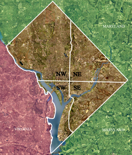
Color-enhanced 2002 USGS satellite image of Washington, D.C. The crosshairs in the image mark the quadrant divisions of Washington, D.C., with the United States Capitol at the center of the dividing lines. To the west of the Capitol is the National Mall, which is visible as a slight green band in the image. The Northwest quadrant is the largest, located north of the National Mall and west of North Capitol Street.

Gallaudet University

Trinity Washington University

Basilica of the National Shrine of the Immaculate Conception
Quadrants of Washington, D.C.
Videos
Page
Washington, D.C., is administratively divided into four geographical quadrants of unequal size, each delineated by their ordinal directions from the medallion located in the Crypt under the Rotunda of the Capitol. Street and number addressing, centered on the Capitol, radiates out into each of the quadrants, producing a number of intersections of identically named cross-streets in each quadrant. Originally, the District of Columbia was a near-perfect square but contained more than one settlement; the Capitol was to be the center of the City of Washington. Thus, the Capitol was never located at the geographic center of the whole territory, which was eventually north of the Potomac River, consolidated into one city. As a result, the quadrants are of greatly varying size. Northwest is quite large, encompassing over a third of the city's geographical area, while Southwest is little more than a few neighborhoods, large parks, and a military base.
Color-enhanced USGS satellite image of Washington, D.C., taken April 26, 2002. The "crosshairs" in the image mark the quadrant divisions of Washington, with the United States Capitol at the center of the dividing lines. To the west of the Capitol extends the National Mall, visible as a slight green band in the image. The Northwest quadrant is the largest, located north of the Mall and west of North Capitol Street.