Ontario Highway 7
Videos
King's Highway 7, commonly referred to as Highway 7 and historically as the Northern Highway, is a provincially maintained highway in the Canadian province of Ontario. At its peak, Highway 7 measured 716 km (445 mi) in length, stretching from Highway 40 east of Sarnia in Southwestern Ontario to Highway 17 west of Ottawa in Eastern Ontario. However, due in part to the construction of Highways 402 and 407, the province transferred the sections of Highway 7 west of London and through the Greater Toronto Area to county and regional jurisdiction. The highway is now 535.7 km (332.9 mi) long; the western segment begins at Highway 4 north of London and extends 154.1 km (95.8 mi) to Georgetown, while the eastern segment begins at Donald Cousens Parkway in Markham and extends 381.6 km (237.1 mi) to Highway 417 in Ottawa.

Highway 7 (York Regional Road 7) at intersection of Warden Avenue (York Regional Road 65) in Markham, in 2008 prior to widening to accommodate Viva Rapid Transit.

Highway 7 near Omemee, in the City of Kawartha Lakes

Highway 7 in Central Frontenac; this section passes through the sparsely developed terrain of the Opeongo Hills
Southwestern Ontario
Videos
Southwestern Ontario is a secondary region of Southern Ontario in the Canadian province of Ontario. It occupies most of the Ontario Peninsula bounded by Lake Huron, including Georgian Bay, to the north and northwest; the St. Clair River, Lake St. Clair, and Detroit River, to the west; and Lake Erie to the south. To the east, on land, Southwestern Ontario is bounded by Central Ontario and the Golden Horseshoe. The region had a population of 2,796,367 in 2021.
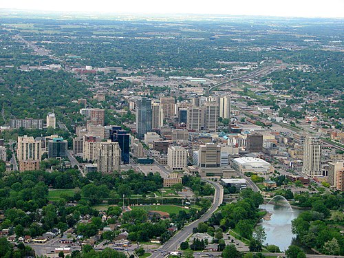
London, Ontario in June 2009.

Bruce Peninsula National Park near Tobermory, Ontario

Ambassador Bridge in Windsor, Ontario

London Knights game at Budweiser Gardens