The Opana Radar Site is a National Historic Landmark and IEEE Milestone that commemorates the first operational use of radar by the United States in wartime, during the attack on Pearl Harbor. It is located off the Kamehameha Highway just inland from the north shore of Oahu, Hawaii, south of Kawela Bay. It is not open to the public.
Opana Radar Site
The attack on Pearl Harbor was a surprise military strike by the Imperial Japanese Navy Air Service on the American naval base at Pearl Harbor in Honolulu, Hawaii, in the United States, just before 8:00 a.m. on Sunday, December 7, 1941. At the time, the United States was a neutral country in the World War II conflict. The attack on Hawaii and other U.S. territories led the United States to formally enter World War II on the side of the Allies the day following the attack, on December 8, 1941. The Japanese military leadership referred to the attack as the Hawaii Operation and Operation AI, and as Operation Z during its planning.
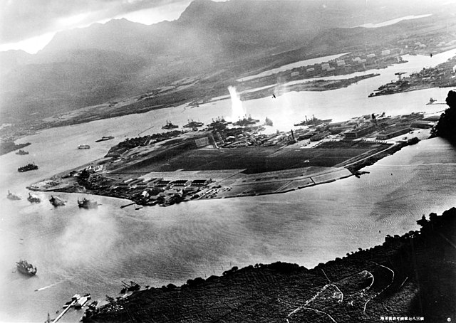
Photograph of Battleship Row taken from a Japanese plane at the beginning of the attack. The explosion in the center is a torpedo strike on USS West Virginia. Two attacking Japanese planes can be seen: one over USS Neosho and one over the Naval Yard.
Pearl Harbor on October 30, 1941, a month prior to the attack, with Ford Island visible (in the center)
The Empire of Japan's 1941 attack plan on Pearl Harbor
The route followed by the Japanese fleet to Pearl Harbor and back


