Orographic lift
Videos
Orographic lift occurs when an air mass is forced from a low elevation to a higher elevation as it moves over rising terrain. As the air mass gains altitude it quickly cools down adiabatically, which can raise the relative humidity to 100% and create clouds and, under the right conditions, precipitation.

A gravity wave cloud pattern—analogous to a ship wake—in the downwind zone behind the Île Amsterdam, seen from above over the far southern Indian Ocean. The island generates wave motion in the wind passing over it, creating regularly spaced orographic clouds. The wave crests raise and cool the air to form clouds, while the troughs remain too low for cloud formation. Note that while the wave motion is generated by orographic lift, it is not required. In other words, one cloud often forms at the peak. See

Precipitation induced by orographic lift in Andalusia.

Windy evening twilight enhanced by the Sun's angle, can visually mimic a tornado resulting from orographic lift

A view of the Front Range of the Rockies capped by a föhn wall.
Rain shadow
Videos
A rain shadow is an area of significantly reduced rainfall behind a mountainous region, on the side facing away from prevailing winds, known as its leeward side.

Effect of a rain shadow
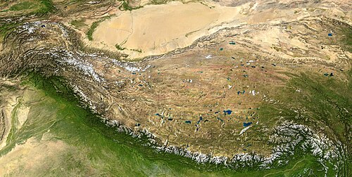
The Tibetan Plateau (center), perhaps the best example of a rain shadow. Rainfalls from the southern South Asian monsoon do not make it far past the Himalayas (seen by the snow line at the bottom), leading to an arid climate on the leeward (north) side of the mountain range and the desertification of the Tarim Basin (top).

The Atlas mountains' (top) rain shadow effect makes the Sahara even drier.

The mountain ranges on the eastern side of Madagascar provide a rain shadow for the country's western portion.