Palmyra Atoll, also referred to as Palmyra Island, is one of the Northern Line Islands. It is located almost due south of the Hawaiian Islands, roughly one-third of the way between Hawaii and American Samoa. North America is about 3,300 miles northeast and New Zealand the same distance southwest, placing the atoll at the approximate center of the Pacific Ocean. The land area is 4.6 sq mi (12 km2), with about 9 miles (14 km) of sea-facing coastline and reef. There is one boat anchorage, known as West Lagoon, accessible from the sea by a narrow artificial channel and an old airstrip; during WW2 it was turned into Naval Air Station for several years and used for training and refueling. It was shelled by a submarine in December 1941, but was not the site of a major battle.
Coconut palms on Strawn Island at Palmyra Atoll
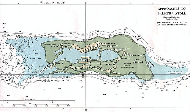
Palmyra Atoll – NOAA Nautical Chart (1:47,500), with many named features.
Welcome sign for Palmyra Atoll, June 2005
Palmyra's North Beach
Kingman Reef is a largely submerged, uninhabited, triangle-shaped reef, geologically an atoll, 9.0 nmi (20 km) east-west and 4.5 nmi (8 km) north-south, in the North Pacific Ocean, roughly halfway between the Hawaiian Islands and American Samoa. It has an area of 3 hectares and is a unincorporated territory of the United States in Oceania. The reef is administered by the United States Fish and Wildlife Service as the Kingman Reef National Wildlife Refuge. It was claimed by the US in 1859, and later used briefly as stopover for commercial Pacific flying boat routes in the 1930s going to New Zealand; however, the route was changed with a different stopover. It was administered by the Navy from 1934 to 2000, and thereafter the Fish and Wildlife service. It has since become a marine protected area. In the 19th century it was noted as maritime hazard, earning the name Hazard Rocks, and is known to have been hit once in 1876. In the 21st century it has been noted for its marine biodiversity and remote nature. There are hundreds of species of fish and coral on and around the reef.

Southeast part of Kingman Reef, looking north
Scuba diver explores corals at Kingman Reef
A derelict shipwreck at Kingman Reef
NOAA nautical chart of Kingman Reef


