Parmer County, Texas
Videos
Parmer County is a county located in the southwestern Texas Panhandle on the High Plains of the Llano Estacado in the U.S. state of Texas. As of the 2020 Census, the population was 9,869. The county seat is Farwell. The county was created in 1876 and later organized in 1907. It is named in honor of Martin Parmer, a signer of the Texas Declaration of Independence and early judge. Parmer County was one of 10 prohibition, or entirely dry, counties in the state of Texas, but is now a wet county.

The Parmer County Courthouse in Farwell

Grain elevator in northwestern Parmer County

Ozark Trail monument in Farwell
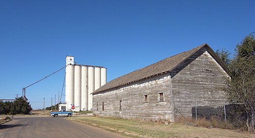
Weathered building and grain elevator in Farwell
Martin Parmer
Videos
Martin Parmer was an eccentric 19th-century American frontiersman, statesman, politician and soldier. On March 2, 1836, Martin Parmer seconded Sam Houston's motion to adopt the Texas Declaration of Independence from Mexico. Parmer signed the Texas Declaration of Independence and was Chairman of the Committee that drafted the Constitution of the Republic of Texas.


Article from the December 29, 1825 edition of the National Gazette and Literary Register published in Philadelphia reporting that Missouri Senator Col. Palmer [Martin Parmer] "is said to have taken French leave and gone to Texas.".

Replica of the building where the Texas Declaration of Independence was signed at Washington-on-the-Brazos, Texas.

Letter by John Forbes in the Friday, April 8, 1836 edition of the Richmond Enquirer newspaper published at Richmond, Virginia.