The physiographic regions of the contiguous United States comprise 8 divisions, 25 provinces, and 85 sections. The system dates to Nevin Fenneman's report Physiographic Divisions of the United States, published in 1916. The map was updated and republished by the Association of American Geographers in 1928. The map was adopted by the United States Geological Survey by publication in 1946.

The term "United States," when used in the geographical sense, refers to the contiguous United States, Alaska, Hawaii, the five insular territories of Puerto Rico, Northern Mariana Islands, U.S. Virgin Islands, Guam, American Samoa, and minor outlying possessions. The United States shares land borders with Canada and Mexico and maritime borders with Russia, Cuba, The Bahamas, and many other countries, mainly in the Caribbeanin addition to Canada and Mexico. The northern border of the United States with Canada is the world's longest bi-national land border.
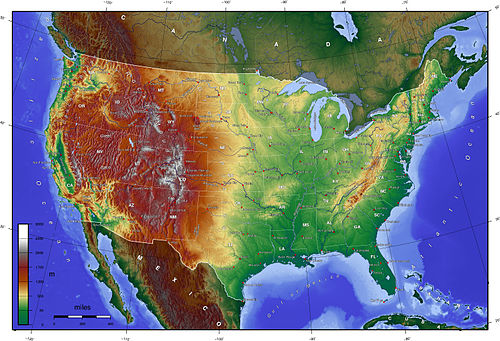

A satellite image of the contiguous United States, where temperate and subtropical forests of deciduous, coniferous, broadleaved evergreen, mixed vegetation, grasslands, montane forests, and croplands prevail are prevalent in the east, transitioning to prairies, boreal forests, the Rockies in the west, and deserts in the southwest. Much of the country's population is centered around the Great Lakes and Atlantic states.

An aerial photo over northern Ohio; much of the central United States is covered by relatively flat, arable land.

Denali, also known as Mount McKinley, in Alaska, is the highest land-based mountain in the world, at 20,310 ft (6,190.5 m).