1.
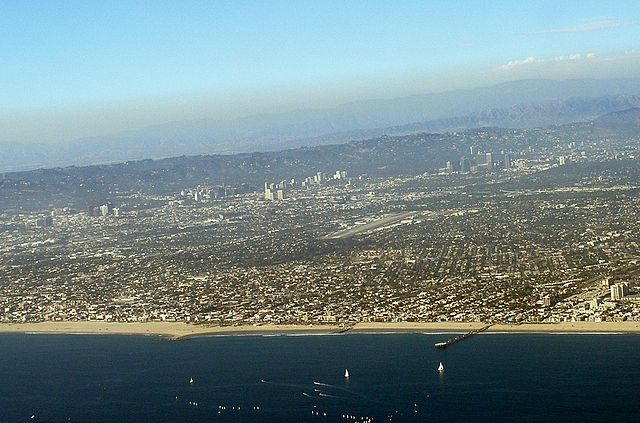
Westside (Los Angeles County)
–
The Los Angeles Westside is an urban region in western Los Angeles County, California. In 2000, non-Hispanic whites made up 63% of the population, the areas within the city of Los Angeles that Los Angeles Almanac recognized as part of the Westside had a population of 413,351. Fifty-three percent of West Los Angeles residents aged 25 and older had earned a degree by 2000. They included 89,620 people with degrees or higher and 117,695 with bachelors degrees. In addition,95,187 people in age range had some college experience. There were 46,823 with high school diplomas but 40,451 who had dropped out before graduating, the Westside is home to the University of California, Los Angeles, a public research university in the Westwood neighborhood. It is the second-oldest of the ten campuses of the University of California system, UCLA is considered a flagship campus of the University of California system, along with UC Berkeley. It offers undergraduate and graduate programs in a wide range of disciplines. Other post-secondary schools in the Westside are, Santa Monica College, current enrollment is over 30,000 students in more than 90 fields of study. West Los Angeles College, which offers degrees, vocationally oriented programs. Other regions of Los Angeles County MLA, the Los Angeles County maps and statistics portal. Los Angeles Times, Mapping L. A. TG, the Thomas Guide, Los Angeles County, Rand McNally, pages N and O Westside travel guide from Wikivoyage
2.
Geographic coordinate system
–
A geographic coordinate system is a coordinate system used in geography that enables every location on Earth to be specified by a set of numbers, letters or symbols. The coordinates are chosen such that one of the numbers represents a vertical position. A common choice of coordinates is latitude, longitude and elevation, to specify a location on a two-dimensional map requires a map projection. The invention of a coordinate system is generally credited to Eratosthenes of Cyrene. Ptolemy credited him with the adoption of longitude and latitude. Ptolemys 2nd-century Geography used the prime meridian but measured latitude from the equator instead. Mathematical cartography resumed in Europe following Maximus Planudes recovery of Ptolemys text a little before 1300, in 1884, the United States hosted the International Meridian Conference, attended by representatives from twenty-five nations. Twenty-two of them agreed to adopt the longitude of the Royal Observatory in Greenwich, the Dominican Republic voted against the motion, while France and Brazil abstained. France adopted Greenwich Mean Time in place of local determinations by the Paris Observatory in 1911, the latitude of a point on Earths surface is the angle between the equatorial plane and the straight line that passes through that point and through the center of the Earth. Lines joining points of the same latitude trace circles on the surface of Earth called parallels, as they are parallel to the equator, the north pole is 90° N, the south pole is 90° S. The 0° parallel of latitude is designated the equator, the plane of all geographic coordinate systems. The equator divides the globe into Northern and Southern Hemispheres, the longitude of a point on Earths surface is the angle east or west of a reference meridian to another meridian that passes through that point. All meridians are halves of great ellipses, which converge at the north and south poles, the prime meridian determines the proper Eastern and Western Hemispheres, although maps often divide these hemispheres further west in order to keep the Old World on a single side. The antipodal meridian of Greenwich is both 180°W and 180°E, the combination of these two components specifies the position of any location on the surface of Earth, without consideration of altitude or depth. The grid formed by lines of latitude and longitude is known as a graticule, the origin/zero point of this system is located in the Gulf of Guinea about 625 km south of Tema, Ghana. To completely specify a location of a feature on, in, or above Earth. Earth is not a sphere, but a shape approximating a biaxial ellipsoid. It is nearly spherical, but has an equatorial bulge making the radius at the equator about 0. 3% larger than the radius measured through the poles, the shorter axis approximately coincides with the axis of rotation
3.
Los Angeles
–
Los Angeles, officially the City of Los Angeles and often known by its initials L. A. is the cultural, financial, and commercial center of Southern California. With a census-estimated 2015 population of 3,971,883, it is the second-most populous city in the United States, Los Angeles is also the seat of Los Angeles County, the most populated county in the United States. The citys inhabitants are referred to as Angelenos, historically home to the Chumash and Tongva, Los Angeles was claimed by Juan Rodríguez Cabrillo for Spain in 1542 along with the rest of what would become Alta California. The city was founded on September 4,1781, by Spanish governor Felipe de Neve. It became a part of Mexico in 1821 following the Mexican War of Independence, in 1848, at the end of the Mexican–American War, Los Angeles and the rest of California were purchased as part of the Treaty of Guadalupe Hidalgo, thereby becoming part of the United States. Los Angeles was incorporated as a municipality on April 4,1850, the discovery of oil in the 1890s brought rapid growth to the city. The completion of the Los Angeles Aqueduct in 1913, delivering water from Eastern California, nicknamed the City of Angels, Los Angeles is known for its Mediterranean climate, ethnic diversity, and sprawling metropolis. Los Angeles also has an economy in culture, media, fashion, science, sports, technology, education, medicine. A global city, it has been ranked 6th in the Global Cities Index, the city is home to renowned institutions covering a broad range of professional and cultural fields, and is one of the most substantial economic engines within the United States. The Los Angeles combined statistical area has a gross metropolitan product of $831 billion, making it the third-largest in the world, after the Greater Tokyo and New York metropolitan areas. The city has hosted the Summer Olympic Games in 1932 and 1984 and is bidding to host the 2024 Summer Olympics and thus become the second city after London to have hosted the Games three times. The Los Angeles area also hosted the 1994 FIFA mens World Cup final match as well as the 1999 FIFA womens World Cup final match, the mens event was watched on television by over 700 million people worldwide. The Los Angeles coastal area was first settled by the Tongva, a Gabrielino settlement in the area was called iyáangẚ, meaning poison oak place. Gaspar de Portolà and Franciscan missionary Juan Crespí, reached the present site of Los Angeles on August 2,1769, in 1771, Franciscan friar Junípero Serra directed the building of the Mission San Gabriel Arcángel, the first mission in the area. The Queen of the Angels is an honorific of the Virgin Mary, two-thirds of the settlers were mestizo or mulatto with a mixture of African, indigenous and European ancestry. The settlement remained a small town for decades, but by 1820. Today, the pueblo is commemorated in the district of Los Angeles Pueblo Plaza and Olvera Street. New Spain achieved its independence from the Spanish Empire in 1821, during Mexican rule, Governor Pío Pico made Los Angeles Alta Californias regional capital
4.
California
–
California is the most populous state in the United States and the third most extensive by area. Located on the western coast of the U. S, California is bordered by the other U. S. states of Oregon, Nevada, and Arizona and shares an international border with the Mexican state of Baja California. Los Angeles is Californias most populous city, and the second largest after New York City. The Los Angeles Area and the San Francisco Bay Area are the nations second- and fifth-most populous urban regions, California also has the nations most populous county, Los Angeles County, and its largest county by area, San Bernardino County. The Central Valley, an agricultural area, dominates the states center. What is now California was first settled by various Native American tribes before being explored by a number of European expeditions during the 16th and 17th centuries, the Spanish Empire then claimed it as part of Alta California in their New Spain colony. The area became a part of Mexico in 1821 following its war for independence. The western portion of Alta California then was organized as the State of California, the California Gold Rush starting in 1848 led to dramatic social and demographic changes, with large-scale emigration from the east and abroad with an accompanying economic boom. If it were a country, California would be the 6th largest economy in the world, fifty-eight percent of the states economy is centered on finance, government, real estate services, technology, and professional, scientific and technical business services. Although it accounts for only 1.5 percent of the states economy, the story of Calafia is recorded in a 1510 work The Adventures of Esplandián, written as a sequel to Amadis de Gaula by Spanish adventure writer Garci Rodríguez de Montalvo. The kingdom of Queen Calafia, according to Montalvo, was said to be a land inhabited by griffins and other strange beasts. This conventional wisdom that California was an island, with maps drawn to reflect this belief, shortened forms of the states name include CA, Cal. Calif. and US-CA. Settled by successive waves of arrivals during the last 10,000 years, various estimates of the native population range from 100,000 to 300,000. The Indigenous peoples of California included more than 70 distinct groups of Native Americans, ranging from large, settled populations living on the coast to groups in the interior. California groups also were diverse in their organization with bands, tribes, villages. Trade, intermarriage and military alliances fostered many social and economic relationships among the diverse groups, the first European effort to explore the coast as far north as the Russian River was a Spanish sailing expedition, led by Portuguese captain Juan Rodríguez Cabrillo, in 1542. Some 37 years later English explorer Francis Drake also explored and claimed a portion of the California coast in 1579. Spanish traders made unintended visits with the Manila galleons on their trips from the Philippines beginning in 1565
5.
United States
–
Forty-eight of the fifty states and the federal district are contiguous and located in North America between Canada and Mexico. The state of Alaska is in the northwest corner of North America, bordered by Canada to the east, the state of Hawaii is an archipelago in the mid-Pacific Ocean. The U. S. territories are scattered about the Pacific Ocean, the geography, climate and wildlife of the country are extremely diverse. At 3.8 million square miles and with over 324 million people, the United States is the worlds third- or fourth-largest country by area, third-largest by land area. It is one of the worlds most ethnically diverse and multicultural nations, paleo-Indians migrated from Asia to the North American mainland at least 15,000 years ago. European colonization began in the 16th century, the United States emerged from 13 British colonies along the East Coast. Numerous disputes between Great Britain and the following the Seven Years War led to the American Revolution. On July 4,1776, during the course of the American Revolutionary War, the war ended in 1783 with recognition of the independence of the United States by Great Britain, representing the first successful war of independence against a European power. The current constitution was adopted in 1788, after the Articles of Confederation, the first ten amendments, collectively named the Bill of Rights, were ratified in 1791 and designed to guarantee many fundamental civil liberties. During the second half of the 19th century, the American Civil War led to the end of slavery in the country. By the end of century, the United States extended into the Pacific Ocean. The Spanish–American War and World War I confirmed the status as a global military power. The end of the Cold War and the dissolution of the Soviet Union in 1991 left the United States as the sole superpower. The U. S. is a member of the United Nations, World Bank, International Monetary Fund, Organization of American States. The United States is a developed country, with the worlds largest economy by nominal GDP. It ranks highly in several measures of performance, including average wage, human development, per capita GDP. While the U. S. economy is considered post-industrial, characterized by the dominance of services and knowledge economy, the United States is a prominent political and cultural force internationally, and a leader in scientific research and technological innovations. In 1507, the German cartographer Martin Waldseemüller produced a map on which he named the lands of the Western Hemisphere America after the Italian explorer and cartographer Amerigo Vespucci
6.
Los Angeles International Airport
–
It is most often referred to by its IATA airport code LAX, with the letters pronounced individually. LAX is in the southwestern Los Angeles area along the Pacific Ocean between the neighborhood of Westchester to its north and the city of El Segundo to its immediate south. It is owned and operated by Los Angeles World Airports, an agency of the government of Los Angeles, formerly known as the Department of Airports. In 2015, LAX handled 74,936,256 passengers, the airport holds the claim for the worlds busiest origin and destination airport, and has for many years. To wit, relative to airports, many more travelers begin or end their trips in Los Angeles than use it as a connection. The airport also was the third busiest by aircraft movements. It is also the airport to rank among the top five U. S. airports for both passenger and cargo traffic. It is also notable for being one of the few U. S. airports with four parallel runways, LAX serves as a hub for Alaska Airlines, American Airlines, Delta Air Lines, United Airlines, and Virgin America. The airport serves as a city for Allegiant Air, Air New Zealand, Qantas, Southwest Airlines, Spirit Airlines. LAX serves as either a hub or focus city for more Mainline US Carriers than any airport in the Country and is the only airport that all three legacy carriers have designated a hub. As the largest international airport on the U. S, West Coast, LAX is a major gateway to and from Europe, Latin America, Asia and Oceania. With its deep connections to Asia and Latin America in particular, in 1928, the Los Angeles City Council selected 640 acres in the southern part of Westchester for a new airport. The fields of wheat, barley and lima beans were converted into dirt landing strips without any terminal buildings and it was named Mines Field for William W. Mines, the real estate agent who arranged the deal. 1, was erected in 1929 and is in the National Register of Historic Places, Mines Field opened as the airport of Los Angeles in 1930 and the city purchased it to be a municipal airfield in 1937. The name became Los Angeles Airport in 1941 and Los Angeles International Airport in 1949, in the 1930s the main airline airports were Burbank Airport in Burbank and the Grand Central Airport in Glendale. Mines Field did not extend west of Sepulveda Boulevard, Sepulveda was rerouted circa 1950 to loop around the west ends of the extended east–west runways, which by November 1950 were 6,000 feet long. A tunnel was completed in 1953 allowing Sepulveda Boulevard to revert to straight, for the next few years the two runways were 8,500 feet long. Before the 1930s, existing airports used a two-letter abbreviation based on the stations at the airports
7.
Hughes Airport (California)
–
The Hughes Airport was a private airport owned by Howard Hughes for the Hughes Aircraft Company. It was located just north of the Westchester bluffs and district of Los Angeles, California and it was directly south of and along Jefferson Boulevard and Ballona Creek, the location of the present day planned community development of Playa Vista. In 1940 Howard Hughes bought 380 acres of the Ballona wetlands south of Jefferson Avenue in south-west Culver City, a total of 9,600 feet were available for a runway and an unpaved runway 23/5 was operational in 1943. In 19486,800 feet were paved with asphalt, extended by 1962 to 8,800 feet, takeoffs to the west had to be coordinated with nearby Los Angeles International Airport. The field served a number of aircraft and helicopter development projects of the Hughes Aircraft Co. and Hughes Tool Company. The Spruce Goose, officially known as the Hughes H-4 Hercules, was here and moved in sections to the Port of Long Beach where it was re-assembled and made its first. A full-time crew of 300 workers, all sworn to secrecy, the crew was reduced to 50 workers in 1962 and then disbanded after Hughess death in 1976. By the mid-1990s, the former Hughes Aircraft hangars here, including the one held the Hercules, were converted into sound stages. Scenes from movies such as Titanic, What Women Want, and End of Days have been filmed in the 315 and it also features in the computer game Crimson Skies. The hangar will be preserved as a structure eligible for listing on the National Register of Historic Buildings, the former Hughes Airport is currently occupied by The YouTube Space LA, part of the Playa Vista development
8.
Hughes Aircraft Company
–
The Hughes Aircraft Company was a major American aerospace and defense contractor founded in 1932 by Howard Hughes in Glendale, California as a division of Hughes Tool Company. During World War II the company designed and built prototype aircraft at Hughes Airport. These included the famous Hughes H-4 Hercules, better known by the nickname for it, the Spruce Goose, the H-1 racer, D-2. At the start of the war Hughes Aircraft had only four full-time employees—by the end the number was 80,000. Hughes Aircraft was one of many aerospace and defense companies which flourished in Southern California during, by the summer of 1947 certain politicians had become concerned about Hughes alleged mismanagement of the Spruce Goose and the XF-11 photo reconnaissance plane project. They formed a committee to investigate Hughes which culminated in a much-followed Senate investigation. Despite a highly critical report, Hughes was cleared. In 1948 Hughes created a new division of the company, the Aerospace Group, two Hughes engineers, Simon Ramo and Dean Wooldridge, had new ideas on the packaging of electronics to make complete fire control systems. Their MA-1 system combined signals from the radar with a digital computer to automatically guide the interceptor aircraft into the proper position for firing missiles. At the same time other teams were working with the newly formed US Air Force on air-to-air missiles, delivering the AIM-4 Falcon, the MA-1/Falcon package, with several upgrades, was the primary interceptor weapon system of the USAF for many years, lasting into the 1980s. The company became TRW in 1965, another company and a major competitor to Hughes Aircraft. In 1951 Hughes Aircraft Co. built a plant in Tucson. By the end of year, the U. S. Air Force had purchased the property. This Tucson plant is still in operation under the ownership of Raytheon Co, Howard Hughes donated Hughes Aircraft to the newly formed Howard Hughes Medical Institute in 1953 allegedly as a way of avoiding taxes on its huge income. Pat Hyland was hired as president and general manager of Hughes Aircraft, he would ultimately become company president. Under Hylands guidance, the Aerospace Group continued to diversify and become massively profitable, the company developed radar systems, electro-optical systems, the first working laser, aircraft computer systems, missile systems, ion-propulsion engines, and many other advanced technologies. The Electronic Properties Information Center of the United States was hosted at the Hughes Culver City library in the 1970s, EPIC published the multi-volume Handbook of Electronic Materials as public documents. Greg Jarvis and Ronald McNair, two of the astronauts on the last flight of the Space Shuttle Challenger, were Hughes alumni, Hughes Aircraft Ground Systems Group was located in Fullerton, California
9.
Hughes H-4 Hercules
–
The Hughes H-4 Hercules is a prototype strategic airlift flying boat designed and built by the Hughes Aircraft Company. Intended as a transatlantic flight transport for use during World War II, the aircraft made only one brief flight on November 2,1947, and the project never advanced beyond the single example produced. Built from wood because of restrictions on the use of aluminium and concerns about weight, it was nicknamed by critics the Spruce Goose. The Hercules is the largest flying boat built and has the largest wingspan of any aircraft in history. It remains in condition and is on display at the Evergreen Aviation & Space Museum in McMinnville, Oregon. War Department needed to transport war materiel and personnel to Britain, allied shipping in the Atlantic Ocean was suffering heavy losses to German U-boats, so a requirement was issued for an aircraft that could cross the Atlantic with a large payload. Wartime priorities meant the aircraft could not be made of strategic materials, the aircraft was the brainchild of Henry J. Kaiser, a leading Liberty ship builder. He teamed with aircraft designer Howard Hughes to create what would become the largest aircraft built at that time and it was designed to carry 150,000 pounds,750 fully equipped troops or two 30-ton M4 Sherman tanks. The original designation HK-1 reflected the Hughes and Kaiser collaboration, the HK-1 contract was issued in 1942 as a development contract and called for three aircraft to be constructed in two years for the war effort. Seven configurations were considered, including twin-hull and single-hull designs with combinations of four, six, the final design chosen was a behemoth, eclipsing any large transport then built. It would be mostly of wood to conserve metal, and was nicknamed the Spruce Goose or the Flying Lumberyard. While Kaiser had originated the flying cargo ship concept, he did not have a background and deferred to Hughes and his designer. Construction of the first HK-1 took place 16 months after the receipt of the development contract, Kaiser then withdrew from the project. Hughes continued the program on his own under the designation H-4 Hercules, work proceeded slowly, and the H-4 was not completed until well after the war was over. The specialized wood veneer was made by Roddis Manufacturing in Marshfield, hamilton Roddis had teams of young women ironing the strong birch wood veneer before shipping to California. A house moving company transported the airplane on streets to Pier E in Long Beach and they moved it in three large sections, the fuselage, each wing—and a fourth, smaller shipment with tail assembly parts and other smaller assemblies. After Hughes Aircraft completed final assembly, they erected a hangar around the flying boat, Howard Hughes was called to testify before the Senate War Investigating Committee in 1947 over the use of government funds for the aircraft. During a Senate hearing on August 6,1947, Hughes said and it is the largest aircraft ever built
10.
Planned community
–
A planned community, or planned city, is any community that was carefully planned from its inception and is typically constructed in a previously undeveloped area. This contrasts with settlements that evolve in an ad hoc fashion. Land use conflicts are less frequent in these communities, the term new town refers to planned communities of the new towns movement in particular, mainly in the United Kingdom. It was also common in the European colonization of the Americas to build according to a plan either on ground or on the ruins of earlier Native American cities. C. in the United States. In Egypt, a new capital city east of Cairo has been proposed, the federal administrative centre of Malaysia, Putrajaya, is also a planned city. Abu Dhabi and some of the recently built cities in the Persian Gulf region are also planned cities, prior to the boom, these were just villages or towns. The city of Gaborone was planned and constructed in the 1960s, in 2012, President Teodoro Obiang decided to move the capital to a new jungle site at Oyala. Konza Technology City is a city that is hoped to become a hub of African science. The capital, Abuja, is a city and was built mainly in the 1980s. Upon completion, the new city which is still under development is anticipating 250,000 residents, centenary City, in the Federal Capital Territory, is another planned smart city under development. The city is designed to become a major tourist attraction to the country, a list of Nigerian cities and neighbourhoods that went through a form of planning are as follows, Abuja, one of the most populous planned cities, and the fastest growing city in the world. Ikeja, the capital of Lagos State Lekki, a new city in Lagos State Lekki Free Zone, a trade zone in the Lekki Orange Island. Victoria Island in Lagos, Lagos State A number of cities were set up during the apartheid-era for a variety of ethnic groups, Planned settlements set up for white inhabitants included Welkom, Sasolburg and Secunda. Additionally the majority of settlements in South Africa were planned in their early stages, some settlements were also set up for non whites such as the former homeland capital of Bhisho. Naypyidaw is the capital of Myanmar, also known as Burma and it is administered as the Naypyidaw Union Territory, as per the 2008 Constitution. On 6 November 2005, the capital of Burma was officially moved to a greenfield 3.2 km west of Pyinmana, and approximately 300 km north of Yangon. The capitals official name was announced on 27 March 2006, Burmese Armed Forces Day, much of the city was still under construction as late as 2012. As of 2009, the population was 925,000, which makes it Burmas third largest city, after Yangon, famous examples are Changan in Tang dynasty and Beijing
11.
Santa Monica, California
–
Santa Monica is a beachfront city in western Los Angeles County, California, United States. The Census Bureau population for Santa Monica in 2010 was 89,736, due in part to an agreeable climate, Santa Monica became a famed resort town by the early 20th century. The city has experienced a boom since the late 1980s through the revitalization of its core, significant job growth. The Santa Monica Pier remains a popular and iconic destination, Santa Monica was long inhabited by the Tongva people. Santa Monica was called Kecheek in the Tongva language, the first non-indigenous group to set foot in the area was the party of explorer Gaspar de Portolà, who camped near the present-day intersection of Barrington and Ohio Avenues on August 3,1769. Named after the Christian saint Monica, there are two different accounts of how the name came to be. One says it was named in honor of the feast day of Saint Monica, another version says it was named by Juan Crespí on account of a pair of springs, the Kuruvungna Springs, that were reminiscent of the tears Saint Monica shed over her sons early impiety. In Los Angeles, several battles were fought by the Californios, following the Mexican–American War, Mexico signed the Treaty of Guadalupe Hidalgo, which gave Mexicans and Californios living in state certain unalienable rights. US government sovereignty in California began on February 2,1848, in the 1870s the Los Angeles and Independence Railroad, connected Santa Monica with Los Angeles, and a wharf out into the bay. The first town hall was a modest 1873 brick building, later a beer hall and it is Santa Monicas oldest extant structure. By 1885, the towns first hotel was the Santa Monica Hotel, around the start of the 20th century, a growing population of Asian Americans lived in and around Santa Monica and Venice. A Japanese fishing village was near the Long Wharf while small numbers of Chinese lived or worked in Santa Monica, the two ethnic minorities were often viewed differently by White Americans who were often well-disposed towards the Japanese but condescending towards the Chinese. The Japanese village fishermen were an economic part of the Santa Monica Bay community. Donald Wills Douglas, Sr. built a plant in 1922 at Clover Field for the Douglas Aircraft Company, in 1924, four Douglas-built planes took off from Clover Field to attempt the first aerial circumnavigation of the world. Two planes returned after covering 27,553 miles in 175 days, the Douglas Company kept facilities in the city until the 1960s. The Great Depression hit Santa Monica deeply, one report gives citywide employment in 1933 of just 1,000. Hotels and office building owners went bankrupt, in the 1930s, corruption infected Santa Monica. The federal Works Project Administration helped build several buildings, most notably City Hall, the main Post Office and Barnum Hall were also among other WPA projects
12.
Venice, Los Angeles
–
Venice is a residential, commercial and recreational beachfront neighborhood on the Westside of the Californian city of Los Angeles. Venice was founded in 1905 as a resort town. It was an independent city until 1926, when it merged with Los Angeles, today, Venice is known for its canals, beaches, and the circus-like Ocean Front Walk, a two-and-a-half-mile pedestrian-only promenade that features performers, mystics, artists and vendors. Venice, originally called Venice of America, was founded by tobacco millionaire Abbot Kinney in 1905 as a resort town,14 miles west of Los Angeles. He and his partner Francis Ryan had bought two miles of oceanfront property south of Santa Monica in 1891 and they built a resort town on the north end of the property, called Ocean Park, which was soon annexed to Santa Monica. After Ryan died, Kinney and his new partners continued building south of Navy Street, tourists, mostly arriving on the Red Cars of the Pacific Electric Railway from Los Angeles and Santa Monica, then rode the Venice Miniature Railway and gondolas to tour the town. But the biggest attraction was Venices mile-long gently sloping beach, cottages and housekeeping tents were available for rent. The population soon exceeded 10,000, the town drew 50,000 to 150,000 tourists on weekends. Attractions on the Kinney Pier became more amusement-oriented by 1910, when a Venice Miniature Railway, Aquarium, Virginia Reel, Whip, Racing Derby, and other rides and game booths were added. Since the business district was allotted only three streets, and the City Hall was more than a mile away, other competing business districts developed. Unfortunately, this created a political climate. Kinney, however, governed with a hand and kept things in check. When he died in November 1920, Venice became harder to govern, with the amusement pier burning six weeks later in December 1920, and Prohibition, the towns tax revenue was severely affected. The Kinney family rebuilt their amusement pier quickly to compete with Ocean Parks Pickering Pleasure Pier, when it opened it had two roller coasters, a new Racing Derby, a Noahs Ark, a Mill Chutes, and many other rides. By 1925 with the addition of a coaster, a tall Dragon Slide, Fun House. Several hundred thousand tourists visited on weekends, in 1923 Charles Lick built the Lick Pier at Navy Street in Venice, adjacent to the Ocean Park Pier at Pier Avenue in Ocean Park. Another pier was planned for Venice in 1925 at Leona Street, for the amusement of the public, Kinney hired aviators to do aerial stunts over the beach. One of them, movie aviator and Venice airport owner B. H. DeLay and he also initiated the first aerial police in the nation, after a marine rescue attempt was thwarted
13.
Tongva
–
The Tongva are Native Americans who inhabited the Los Angeles Basin and the Southern Channel Islands, an area covering approximately 4,000 square miles. The Tongva are also known as the Gabrieleño and Fernandeño, names derived from the Spanish missions built near their territory, Mission San Gabriel Arcángel, along with the neighboring Chumash, the Tongva were the most powerful indigenous people to inhabit Southern California. At the time of European contact, they may have numbered 5,000 to 10,000, many lines of evidence suggest that the Tongva are descended of Uto-Aztecan-speaking peoples from Nevada who moved southwest into coastal Southern California 3,500 years ago. These migrants either absorbed or pushed out the Hokan-speaking peoples in the region, by 500 AD, the Tongva had come to occupy all the lands now associated with them. A hunter-gatherer society, the Tongva traded widely with neighboring peoples, over time, scattered communities came to speak distinct dialects of the Tongva language, part of the Takic subgroup of the Uto-Aztecan language family. There may have five or more such dialects. The Tongva language became extinct in the century, but a reconstructed form continues to be spoken today. Initial Spanish exploration of the Los Angeles area occurred in 1542 and this marked the beginning of an era of forced relocation and exposure to Old World diseases, leading to the rapid collapse of the Tongva population. At times the Tongva violently resisted Spanish rule, such as the 1785 rebellion led by the female chief Toypurina, in 1821, Mexico gained its independence from Spain and the government sold mission lands to ranchers, forcing the Tongva to culturally assimilate. Three decades later, California was ceded to the United States following the Mexican–American War, the US government signed treaties with the Tongva, promising 8.5 million acres of land for reservations, but these treaties were never ratified. By the turn of the 20th century, the Island Tongva had disappeared, the endonym Tongva was recorded by American ethnographer C. Hart Merriam in 1903 and has been widely adopted by scholars and descendants, although some prefer the endonym Kizh. Two of the groups are the result of a split over the question of building an Indian casino. In 1994, the state of California recognized the Tongva as the tribe of the Los Angeles Basin. In 2008, more than 1,700 people identified as Tongva or claimed partial ancestry, the first record of an endonym for the Tongva people was Kizh, from 1846. Although subsequent authors equated this with the word for house, Hale gives the word for house as kītç in a list where the language was called Kīj, suggesting that the words were distinct. The term Kizh was generally used at that time to designate the language, in 1875, Yarrow indicated that the name Kizh was unknown at Mission San Gabriel. He reported that the natives called themselves Tobikhar, meaning settlers, in 1885, Hoffman also referred to the natives as Tobikhar. The word Tongva was recorded by Merriam in 1903 from a single informant and he spelled it Tong-vā, by his orthography, it would be pronounced /ˈtɒŋveɪ/, TONG-vay
14.
Native Americans in the United States
–
In the United States, Native Americans are people descended from the Pre-Columbian indigenous population of the land within the countrys modern boundaries. These peoples were composed of distinct tribes, bands, and ethnic groups. Most Native American groups had historically preserved their histories by oral traditions and artwork, at the time of first contact, the indigenous cultures were quite different from those of the proto-industrial and mostly Christian immigrants. Some of the Northeastern and Southwestern cultures in particular were matrilineal, the majority of Indigenous American tribes maintained their hunting grounds and agricultural lands for use of the entire tribe. Europeans at that time had patriarchal cultures and had developed concepts of property rights with respect to land that were extremely different. Assimilation became a consistent policy through American administrations, during the 19th century, the ideology of manifest destiny became integral to the American nationalist movement. Expansion of European-American populations to the west after the American Revolution resulted in increasing pressure on Native American lands and this resulted in the ethnic cleansing of many tribes, with the brutal, forced marches coming to be known as The Trail of Tears. As American expansion reached into the West, settler and miner migrants came into increasing conflict with the Great Basin, Great Plains and these were complex nomadic cultures based on horse culture and seasonal bison hunting. Over time, the United States forced a series of treaties and land cessions by the tribes, in 1924, Native Americans who were not already U. S. citizens were granted citizenship by Congress. Contemporary Native Americans have a relationship with the United States because they may be members of nations, tribes. The terms used to refer to Native Americans have at times been controversial, by comparison, the indigenous peoples of Canada are generally known as First Nations. It is not definitively known how or when the Native Americans first settled the Americas and these early inhabitants, called Paleoamericans, soon diversified into many hundreds of culturally distinct nations and tribes. The archaeological periods used are the classifications of archaeological periods and cultures established in Gordon Willey and Philip Phillips 1958 book Method and they divided the archaeological record in the Americas into five phases, see Archaeology of the Americas. The Clovis culture, a hunting culture, is primarily identified by use of fluted spear points. Artifacts from this culture were first excavated in 1932 near Clovis, the Clovis culture ranged over much of North America and also appeared in South America. The culture is identified by the distinctive Clovis point, a flaked flint spear-point with a notched flute, dating of Clovis materials has been by association with animal bones and by the use of carbon dating methods. Recent reexaminations of Clovis materials using improved carbon-dating methods produced results of 11,050 and 10,800 radiocarbon years B. P, other tribes have stories that recount migrations across long tracts of land and a great river, believed to be the Mississippi River. Genetic and linguistic data connect the people of this continent with ancient northeast Asians
15.
Rancho La Ballona
–
Rancho La Ballona was a 13, 920-acre Mexican land grant in the present-day Westside region of Los Angeles County, southern California. The rancho was confirmed by Alta California Governor Juan Alvarado in 1839, to Ygnacio and Augustin Machado and Felipe, the Machados and Talamantes had already been given a Spanish concession to graze their cattle on this land in 1819. The grant stretched inland from the ocean into what is now Mar Vista, Westside Village, Palms, and Culver City and north to Pico Boulevard in Santa Monica, and south to Playa Del Rey. Augustin Machado and Felipe Talamantes were given a permit in 1819 for Rancho de Los Quintos in Santa Barbara. In 1821 they applied again, joined by Augustins brother Ygnacio, the military commander, José de la Guerra y Noriega, gave them permission to graze cattle on the future Rancho La Ballona lands, when they were living in the Pueblo de Los Ángeles. In 1839 Mexican Governor Alvarado confirmed the grant for Rancho La Ballona to them. Port Ballona was a settlement on the rancho located at the mouth of Ballona Creek, the cession of California to the United States followed the Mexican-American War, and the 1848 Treaty of Guadalupe Hidalgo promised that the existingland grants would be honored. In accordance with the Land Act of 1851, the Machados and Talamantes registered their claim for Rancho La Ballona with the Board of California Land Commissioners, and it was approved in 1854. The US District Court upheld the decision on appeal in 1873,8 years after Agustín Machado had died, in 1857, Benjamin D. Wilson received title to one fourth of Rancho La Ballona on a foreclosure of a loan he had made to Tomas Talamantes in 1854. Wilson sold his portion of Rancho La Ballona to George A. Sanford and John D. Young, a decree dividing it into 23 sections was issued in 1868. Each of the 23 long narrow parcels was to have three types of land, pasture, irrigable, and bay. During the Civil War General George Wright ordered troops to secure Port Ballona against a possible seizure by pro-Confederates and their post was named Camp Latham, after Milton Latham. José Manuel Machado married María de la Luz Valenzuela Y Avilas in 1780, in 1781, Machado retired to the Pueblo de Los Angeles. Two of his sons, José Agustín Antonio Machado and José Ygnacio Antonio Machado, Agustín Machado married María Petra Buelna in 1824, but she died while giving birth to their first child, Juan Bautista. Cattle and sheep rancher Juan Moreno sold the Rancho Santa Rosa to Augustin Machado in 1855, subsequently Abel Stearns sold the nearby Rancho La Laguna to Augustin Machado in 1858. This later acquisition also was the site of one of the Butterfield Overland Mail stage stations until 1861, Francisco Machado, son of Agustín Machado, served as a Los Angeles County Supervisor for two terms. He assumed office in 1872 and was re-elected in 1874, lake Machado in Harbor City was named in his honor. Francisco Lugo was the brother of José del Carmen Lugo, in 1826, Ygnacio Machado married Estefana Palomares they had 7 children, Luisa, Versabe, María, José, Andres, Francisco and Rafael
16.
Port Ballona
–
Port Ballona was located, from 1839 to 1903, in the area where Marina del Rey, California and the beach, Playa Del Rey, along Santa Monica Bay, lie. The name comes from the La Ballona land grant, Port Ballona also included the Ballona Wetlands marsh. Ballona Creek flows in to the marsh, later, in 1859, Wilson, for $5000, sold 3,480 acres of Rancho La Ballona to George A. Sanford and John D. Young. During the Civil War, General George Wright ordered troops to secure Port Ballona against any Confederacy invasion, by 1862, the troop camp was called Camp Latham after Milton Latham. The Great Flood of 1862 turned the Port and the land around it into a swamp for six months, in 1863, Louis Mesmer sold his Los Angeles bakery and purchased extensive land holdings from the Machados, including Port Ballona. In 1887, Louis Mesmer and Moye Wicks made a small Port Harbor at Port Ballona, Moye Wicks starts the Ballona Harbor and Improvement Company in 1887, with plans to make the port a major sea port. August 21,1887, the Town of Port Ballona was developed by Louis Mesmer, by 1889, Ballona Harbor and Improvement Company was out of funds to complete the maintain and expand the port, they could not keep the Port open. Louis Mesmer and Moye Wicks sold the port and land around the port to Moses Sherman, Sherman purchased 1,000 acres of land around the Ballona lagoon and the Port Ballona in 1902 under the name, Beach Land Company. The rail line ran from the port to Redondo junction Sherman and Clark renamed the port, Port Ballona, in 1903, was renamed Playa Del Rey by Sherman and Clark. Port Ballona Street car depot, built by Shermans Redondo and Hermosa Beach Railroad, was part of the Los Angeles Pacific Railroad, the Shermans tram line opened in December 1902, it departed Downtown Los Angeles at 4th & Broadway. In the 1880s and 1890s, parts of Venice, Playa Vista, Culver City, Port of Los Angeles Long Wharf Santa Monica Port of Los Angeles San Pedro Port of Long Beach
17.
Marina del Rey, California
–
Marina del Rey is an unincorporated seaside community and census-designated place in Los Angeles County, California. A Westside locale, the population was 8,866 at the 2010 census, the harbor, the Los Angeles Times said in 1997, is perhaps the countys most valuable resource. Prior to its development as a small harbor, the land occupied by Marina del Rey was a salt-marsh fed by fresh water from Ballona Creek, frequented by duck hunters. Burton W. Chace, a member of the Los Angeles County Board of Supervisors, referred to the area as mud flats, in the mid-19th century, Moye C. Wicks and Louis Mesmer thought of turning this Playa del Rey estuary into a commercial port and he formed the Ballona Development Company in 1888 to develop the area, but three years later the company went bankrupt. Port Ballona made by Louis Mesmer and Moye Wicks was then sold to Moses Sherman, Sherman purchased 1,000 acres of land around the Ballona lagoon and Port Ballona in 1902 under the name the Beach Land Company. Sherman and Clark renamed the land Del Rey, Port Ballona was then renamed Playa Del Rey. The port was serviced by the California Central Railway opened in September 1887, this later became the Santa Fe Railway, that later became the Atchison, Topeka. The rail line ran from the port to Redondo junction, a street car tram line was made to the Port by the Redondo and Hermosa Beach Railroad company, that had incorporated on February 21,1901. This company was part of the Los Angeles Pacific Railroad owned by Sherman, the tram line opened December 1902 departed downtown at 4th & Broadway. In 1916, the U. S. Army Corps of Engineers revisited the idea of a commercial harbor, in 1953, the Los Angeles County Board of Supervisors authorized a $2 million loan to fund construction of the marina. Since the loan only covered half the cost, the U. S. Congress passed. With construction almost complete, the marina was put in danger in 1962–1963 due to a winter storm, the storm caused millions of dollars in damage to both the marina and the few small boats anchored there. A plan was put into effect to build a breakwater at the mouth of the marina, County Board of Supervisors appropriated $2.1 million to build it. On April 10,1965 Marina del Rey was formally dedicated, the total cost of the marina was $36.25 million for land, construction, and initial operation. Marina del Rey falls within unincorporated Los Angeles County and is southeast of the L. A, City community of Venice and north of the L. A. City community of Playa del Rey, near the mouth of Ballona Creek and it is located four miles north of Los Angeles International Airport. It is bounded on all sides by the City of Los Angeles
18.
Ballona Creek
–
It heads in the historical Rancho Las Cienegas and flows through Culver City and the Del Rey district before emptying into Santa Monica Bay between Marina del Rey and the Playa del Rey district. During the Pre-Columbian era, Tongva people existed as hunters and gatherers in small villages throughout the Ballona Creek watershed, native American culture and land management practice was disrupted by the arrival of Spanish explorers. In 1769, the Tongva met their first Europeans when Portola expedition came through on its way north, researchers identified the place as the headwaters of Ballona Creek. The explorers made camp nearby on August 3, Ballona Creek and Lagoon are named for the Ballona or Paseo de las Carretas land grant, dated November 27,1839. The Machado and Talamantes families, co-grantees of the rancho, heralded from Baiona in northern Spain, after the land grant claims were lost, the area then experienced rapid growth, with open land being transformed into agricultural use. The Ballona Creek watershed totals about 130 square miles and its land use consists of 64% residential, 8% commercial, 4% industrial, and 17% open space. At the time of Spanish settlement, the Los Angeles River turned to the west just south of present-day Bunker Hill, however, during a major flood in 1825, the Los Angeles Rivers course changed to its present channel, and Ballona Creek became a completely distinct waterway. Ballona Creek Watershed climate can be characterized as Mediterranean with average rainfall of approximately 15 inches per year over most of the developed portions of the watershed. The flow rate in the Creek varies considerably from a flow of about 14 cubic feet per second during dry weather to 71,400 cubic feet per second during a 50-year storm event. Ballona Wetlands and Del Rey Lagoon are connected to the Ballona Estuary through tide gates, although much of it was drained and developed, much of it is now protected. The State of California owns 600 acres of the wetlands, the CDFG owns 540 acres. Much of these lands are designated as the Ballona Wetlands Ecological Reserve and despite historic degradation. Wetland flora includes pickleweed, marsh heather, saltgrass, arrowgrass and glasswort, and a variety of upland and exotic species including brome, iceplant, oxalis, and ryegrass. Bird species of special interest observed in the reserve include nesting pairs of Belding’s Savannah sparrow, the urbanization of the watershed, and associated with it the pollution of urban runoff and stormwater, has degraded the water quality in Ballona Creek and its Estuary. Ballona Creek is listed by the Los Angeles Regional Water Quality Control Board impaired for fecal coliform, heavy metals, dry weather urban runoff and storm water, both conveyed by storm drains, are the primary sources of pollutions in the Creek. Many national, historical, archeological and cultural landmarks, tourist attractions, educational institutions, with year-round Mediterranean climate, the area attracts immigrants and visitors from all over the world making Ballona Creek Watershed a vibrant melting pot of culture. A bike path that extends almost seven miles from National Boulevard in Culver City to the end of Ballona Creek Estuary provides opportunities for recreation in the area, Ballona Creek Estuary and Ballona Wetlands provide habitat to many species of waterfowls, shorebirds, and waders
19.
Playa del Rey, Los Angeles
–
Playa del Rey is a beachside community in the Westside of the city of Los Angeles, California. It has a ZIP code of 90293 and area codes of 310 and 424, as of 2014, the Playa del Rey population was 12,129 people. Since 2000, it has had a growth of 14.61 percent. Playa del Rey is a neighborhood and a district of City of Los Angeles. The rolling hills are the result of ancient, wind-blown, compacted sand dunes rise up to 125 feet above sea level, originally called. These dunes run parallel to the coastline, from Playa del Rey, the northern part was originally wetlands, but the natural flooding was halted by the concrete channel which contains Ballona Creek. In the 1870s, Playa Del Rey was the location of the first attempt at a harbor in Santa Monica Bay. Under contract with the Atchison, Topeka & Santa Fe Railroad, within three years, winter waves brought flooding, but what remained of mans early efforts became the Playa Del Rey Lagoon, now a regional public park. Palisades del Rey was the name of the original 1921 neighborhood land development by Dickinson & Gillespie Co. that later came to be called Playa del Rey. The company advertised this area of sand dunes as the last stretch of land in the city of Los Angeles to be developed. All of the houses in this area were built, many as beach homes owned by Hollywood actors and producers. The southern portion of the original Playa del Rey development, which came to be known as Surfridge, is now vacant, the noise from the flights made it less desirable to live on the dunes above the ocean under the LAX flight path. The City of Los Angeles condemned the southern section of Playa del Rey under the power of eminent domain, today one can see only barbed-wire fences protecting vacant land and old streets where houses once sat. Recent LAX rejuvenation plans call for the city to remove the old streets that still line the empty neighborhood. The condemned areas of the community are now a habitat of the endangered El Segundo blue butterfly. Playa del Rey in the 1950s and early 1960s was known as a great Los Angeles area surfing spot, but due to the rock jetties that were built to prevent beach erosion. Most surfers now flock south of Dockweiler Beach, to El Porto, the lifeguard and park services are uniform across the entire twenty-mile stretch of beach. One danger for beachgoers is the water runoff from the creek
20.
Howard Hughes
–
Howard Robard Hughes Jr. was an American businessman, investor, pilot, film director, and philanthropist, known during his lifetime as one of the most financially successful individuals in the world. He first made a name for himself as a film producer, later in life, he became known for his eccentric behavior and reclusive lifestyle, oddities that were caused in part by a worsening obsessive–compulsive disorder and chronic pain from a plane crash. As a maverick film tycoon, Hughes gained prominence in Hollywood beginning in the late 1920s, when he made big-budget and often controversial films like The Racket, Hells Angels, later he controlled the RKO film studio. Hughes formed the Hughes Aircraft Company in 1932, hiring numerous engineers and designers and he spent the rest of the 1930s setting multiple world air speed records and building the Hughes H-1 Racer and H-4 Hercules. He acquired and expanded Trans World Airlines and later acquired Air West, Hughes was included in Flying Magazines list of the 51 Heroes of Aviation, ranked at No.25. Today, his legacy is maintained through the Howard Hughes Medical Institute, the birthplace of Howard Hughes is recorded as either Humble or Houston, Texas. The date remains uncertain due to conflicting dates from various sources and he repeatedly claimed that his birthday was on Christmas Eve. A1941 affidavit birth certificate of Hughes that was signed by his aunt Annette Gano Lummis and Estelle Boughton Sharp states that he was born on December 24,1905, in Harris County, Texas. Hughes was the son of Allene Stone Gano and Howard R. Hughes Sr. a successful inventor and he was of English, and some French Huguenot, ancestry, and was a descendant of John Gano, a minister who allegedly baptized George Washington. His father had patented the two-cone roller bit, which allowed rotary drilling for petroleum in previously inaccessible places, the senior Hughes made the shrewd and lucrative decision to commercialize the invention by leasing the bits instead of selling them, and founded the Hughes Tool Company in 1909. Hughes uncle was the famed novelist, screenwriter, and film director Rupert Hughes, at a young age, Hughes demonstrated interest in science and technology. In particular, he had great engineering aptitude and built Houstons first wireless radio transmitter at age 11 and he went on to be one of the first licensed ham radio operators in Houston, having the assigned callsign W5CY. At 12, Hughes was photographed in the newspaper, identified as being the first boy in Houston to have a motorized bicycle. He was an indifferent student, with a liking for mathematics, flying and he took his first flying lesson at 14, and later attended math and aeronautical engineering courses at Caltech. The red brick house where Hughes lived as a teenager at 3921 Yoakum St. Houston today serves as the headquarters of the Theology Department of the University of St. Thomas and his mother Allene died in March 1922 from complications of an ectopic pregnancy. Howard Hughes Sr. died of an attack in 1924. Their deaths apparently inspired Hughes to include the creation of a research laboratory in the will that he signed in 1925 at age 19. Howard Sr. s will had not been updated since Allenes death, on his 19th birthday, Hughes was declared an emancipated minor, enabling him to take full control of his life
21.
Runway
–
According to the International Civil Aviation Organization, a runway is a defined rectangular area on a land aerodrome prepared for the landing and takeoff of aircraft. Runways may be a surface or a natural surface. Runways are named by a number between 01 and 36, which is generally the magnetic azimuth of the heading in decadegrees. This heading differs from true north by the magnetic declination. A runway numbered 09 points east, runway 18 is south, runway 27 points west, when taking off from or landing on runway 09, a plane would be heading 90°. A runway can normally be used in both directions, and is named for each separately, e. g. runway 33 in one direction is runway 15 when used in the other. The two numbers usually differ by 18, Runway Zero Three Left becomes Runway Two One Right when used in the opposite direction. In some countries, if parallel runways are too close to each other, at large airports with four or more parallel runways some runway identifiers are shifted by 10 degrees to avoid the ambiguity that would result with more than three parallel runways. For example, in Los Angeles, this results in runways 6L, 6R, 7L. At Dallas/Fort Worth International Airport, there are five parallel runways, named 17L, 17C, 17R, 18L, for clarity in radio communications, each digit in the runway name is pronounced individually, runway three six, runway one four, etc. A leading zero, for example in runway zero six or runway zero one left, is included for all ICAO, however, most U. S. civil aviation airports drop the leading zero as required by FAA regulation. This also includes some military airfields such as Cairns Army Airfield and this American anomaly may lead to inconsistencies in conversations between American pilots and controllers in other countries. It is very common in a such as Canada for a controller to clear an incoming American aircraft to, for example, runway 04. In flight simulation programs those of American origin might apply U. S. usage to airports around the world, for example, runway 05 at Halifax will appear on the program as the single digit 5 rather than 05. Runway designations change over time because the magnetic poles slowly drift on the Earths surface, depending on the airport location and how much drift takes place, it may be necessary over time to change the runway designation. As runways are designated with headings rounded to the nearest 10 degrees, for example, if the magnetic heading of a runway is 233 degrees, it would be designated Runway 23. If the magnetic heading changed downwards by 5 degrees to 228, if on the other hand the original magnetic heading was 226, and the heading decreased by only 2 degrees to 224, the runway should become Runway 22. Because the drift itself is slow, runway designation changes are uncommon
22.
Hangar
–
A hangar is a closed building structure to hold aircraft, spacecraft or tanks in protective storage. Most hangars are built of metal, but other such as wood. The word hangar comes from Middle French hanghart, of Germanic origin, from Frankish *haimgard, from *haim, hangars are used for protection from the weather, direct sunlight, maintenance, repair, manufacture, assembly and storage of aircraft on airfields, aircraft carriers and ships. The Wright brothers stored and repaired their aircraft in a wooden hangar constructed in 1902 at Kill Devil Hills in North Carolina for their glider, after completing design and construction of the Wright Flyer in Ohio, the brothers returned to Kill Devil Hill only to find their hangar damaged. They repaired the structure and constructed a new workshop while they waited for the Flyer to be shipped, bleriot was in a race to be the first man to cross the English Channel in a heavier-than-air aircraft and set up his headquarters in the unused shed. In Britain, the earliest aircraft hangars were known as aeroplane sheds and these were built in 1910 for the Bristol School of Flying and are now Grade II* Listed buildings. Examples of the latter survive at Farnborough, Filton and Montrose airfields, during World War I, other standard designs included the RFC General Service Flight Shed and the Admiralty F-Type of 1916, the General Service Shed and the Handley Page aeroplane shed. Airship hangars or airship sheds are generally larger than conventional aircraft hangars, most early airships used hydrogen gas to provide them with sufficient buoyancy for flight, so their hangars had to provide protection from stray sparks to keep the gas from exploding. Hangars that held several airships were at risk from chain-reaction explosions, for this reason, most hangars for hydrogen-based airships were built to house only one or two such craft. During the Golden Age of airship travel from 1900, mooring masts and sheds were constructed to build, steel rigid airship hangars are some of the largest in the world. Hangar 1, Lakehurst, is located at Naval Air Engineering Station Lakehurst, the structure was completed in 1921 and is typical of airship hangar designs of World War I. The site is best known for the Hindenburg disaster, when on May 6,1937, Hangar No.1 at Lakehurst was used to build and store the American USS Shenandoah. The hangar also provided service and storage for the airships USS Los Angeles, Akron, Macon, as well as the Graf Zeppelin and the Hindenburg. The largest hangars ever built include the Goodyear Airdock measuring 1, 175x325x211 feet, the Goodyear Airdock, is in Akron, Ohio and the structure was completed on November 25,1929. The Airdock was used for the construction of the USS Akron and her sister ship, Hangar One at Moffett Federal Field, is located in Mountain View, California. The structure was completed in 1931, the US Navy established more airship operations during WWII. As part of this ten lighter-than-air bases across the United States were built as part of the defense plan. Hangars at these bases are some of the worlds largest freestanding timber structures, an alternative to the fixed hangar is a portable shelter that can be used for aircraft storage and maintenance
23.
DreamWorks
–
DreamWorks Pictures is an American film production label of Amblin Partners. It was formerly distributing its own and third-party films by itself and it has produced or distributed more than ten films with box-office grosses of more than $100 million each. As of October 2016, DreamWorks films are marketed and distributed by Universal Pictures, DreamWorks began in 1994 as an attempt by media moguls Steven Spielberg, Jeffrey Katzenberg and David Geffen to create a new Hollywood studio of which they owned 72%. Currently, DreamWorks operates out of offices at Universal Studios, in December 2005, the founders agreed to sell the studio to Viacom, parent of Paramount Pictures. The sale was completed in February 2006, in 2008, DreamWorks announced its intention to end its partnership with Paramount and signed a $1.5 billion deal to produce films with Indias Reliance ADA Group. Reliance provided $325M of equity to fund recreating DreamWorks SKG into DreamWorks Studios, after the formation of Amblin Partners in 2015, the studio entered into a distribution agreement with Universal Pictures. DreamWorks animation arm was spun off in 2004 into DreamWorks Animation SKG, which owns the DreamWorks trademarks. Spielbergs company continues to use the DreamWorks trademarks under license from Universal Studios, the original company was founded following Katzenbergs resignation from The Walt Disney Company in 1994. Katzenberg approached Spielberg and Geffen about forming a live-action and animation film studio, which had not been done in decades due to the risk and expense. They agreed on three conditions, They would make fewer than nine movies a year, they would be free to work for other studios if they chose, and they would go home in time for dinner. They officially founded DreamWorks SKG in October 1994, with backing of $33 million from each of the three partners and $500 million from Microsoft co-founder Paul Allen. Their new studio was based at offices in the Universal Studios lot, despite access to sound stages and sets, DreamWorks preferred to film motion pictures on location. Usually, the company would film in a soundstage or set in a major studio, as of 2016, DreamWorks is still based in Universal. In 1995, traditional animation artists from Amblimation joined the new studio, which led to DreamWorks buying part of Pacific Data Images, both were software divisions, and would merge later on. For then, DreamWorks had the traditional animators working for their animation department. These films were distributed by DreamWorks Pictures, the same year, PDI/DreamWorks produced its first full-length animated features, Antz and The Prince of Egypt, which were also distributed by DreamWorks Pictures. DreamWorks SKG continued to distribute PDI/DreamWorks productions through their name until 2004. In 2000, DreamWorks was planning in building a studio backlot after buying 1,087 acres of land in the Playa Vista area in Los Angeles and it was to be complete with 18 sound stages, with many office buildings and a lake
24.
Presidency of Bill Clinton
–
The presidency of Bill Clinton began on January 20,1993 at noon Eastern Standard Time, when Bill Clinton was inaugurated as President of the United States, and ended on January 20,2001. His running mate, Al Gore, took office as Vice President on the same day, Clinton, a Democrat, took office after defeating Republican incumbent President George H. W. Bush and Independent businessman Ross Perot in the 1992 presidential election. Four years later, he defeated Republican Bob Dole and Ross Perot to win a term of office. During both elections, Clinton ran as a New Democrat, and many of many of his administrations policy proposals reflected his centrist, Third Way thinking. He was succeeded in office by Republican George W. Bush, months into his first term, he signed the Omnibus Budget Reconciliation Act of 1993, which raised taxes and set the stage for future budget surpluses. He also signed into law the North American Free Trade Agreement, a trade pact negotiated by President George H. W. Bush among the United States, Canada, and Mexico. His most ambitious legislative initiative, a plan to provide health care. Clintons party suffered a strong rebuke in the 1994 elections, the Republican Revolution, as the 1994 elections came to be known, empowered Congressional Republicans led by Speaker of the House Newt Gingrich to propose several conservative policies. While Clinton vetoed many of these policies, he signed some, including the Personal Responsibility. After disagreements with Congressional Republicans led to two shutdowns of the government between 1995 and 1996. In foreign policy, Clintons first term saw American interventions in Haiti and the Balkans, Clinton also appointed two Supreme Court Justices, Ruth Bader Ginsburg and Stephen Breyer. Clintons second term saw the first federal budget surpluses since the 1960s and his impeachment arose after he denied having an affair with a White House intern, Monica Lewinsky. Though the House of Representatives voted to impeach Clinton, he was acquitted of all charges by the Senate, in 1997, Clinton signed into law a bill creating the State Childrens Health Insurance Program, which was to help provide health care coverage for millions of children. In 1999, he signed the Gramm–Leach–Bliley Act, which allowed for the consolidation of investment banks, commercial banks, in foreign policy, Clinton launched a major bombing campaign in the Balkans, which led to the creation of a United Nations protectorate in Kosovo. Clinton also pursued trade agreements, most notably with China. Since the end of his presidency, historians and political scientists have tended to rank Clinton as an average to above average president. In the 1992 presidential election, Clinton defeated incumbent Republican president George H. W. Bush to become the first Democratic president since Jimmy Carter left office in 1981, Clinton took office with Democratic majorities in both houses, and attempted to pass an ambitious health care reform bill. Republicans took control of both houses of Congress in 1994 and retained control throughout Clintons presidency, but Clinton won reelection in 1996
25.
Mar Vista, Los Angeles
–
Mar Vista is a residential and commercial neighborhood on the Westside of Los Angeles, California. It is the home of Venice High School, two schools, a branch public library and a city park. The northern apex of the Mar Vista neighborhood is at the San Diego Freeway and National Boulevard, the Zip Code for Mar Vista California is 90066. The median age for residents was 35, considered the average for Los Angeles, the neighborhood was highly diverse ethnically, but the percentage of Asian people was high for the county. The breakdown was whites,51. 3%, Latinos,29. 1%, Asians,12. 8%, blacks,3. 5%, and others,3. 4%. Mexico and Korea were the most common places of birth for the 33. 5% of the residents who were born abroad—considered an average figure for Los Angeles, the median yearly household income in 2008 dollars was $62,611, an average figure for Los Angeles. The average household size of 2.3 people was low for both the city and the county, renters occupied 60. 6% of the housing stock and house- or apartment owners held 39. 4%. The percentages of never-married men, divorced men and divorced women were among the countys highest, the percentages of veterans who served during World War II or the Korean War were among the countys highest. Jimmy Fallon - host of Tonight show Belita Moreno- Actress, played Benita Lopez on the George Lopez show. John Frusciante- musician who is most notable for being the guitarist of The Red Hot Chili Peppers, and who produced several solo albums. The Los Angeles County Department of Health Services SPA5 West Area Health Office serves Mar Vista, the Los Angeles Fire Department operates Station 62, which serves a portion of Venice as well. Los Angeles Police Department operates the Pacific Division Police Station, serving the neighborhood, the Mar Vista Community Council is the city-sanctioned neighborhood council for Mar Vista and other small neighborhoods including Hilltop, Westdale, North Westdale, and others. Forty-two percent of Mar Vista residents aged 25 and older had earned a degree by 2000. The percentages of residents of age with a bachelors degree or a masters degree were also considered high for the county. The schools within Mar Vista are as follows, Windward School, accredited by the Western Association of Schools and Colleges, Windward was founded by writer/teacher Shirley Windward in 1971. It moved to a new structure at its present location a decade later. At the elementary school, Wildwood incorporates multi-age primary classes, for kindergarten and first grade, students learn together in Pods. There are four pods, and each pod contains children mixed together in class size
26.
Traffic congestion
–
Traffic congestion is a condition on transport networks that occurs as use increases, and is characterized by slower speeds, longer trip times, and increased vehicular queueing. The most common example is the use of roads by vehicles. When traffic demand is great enough that the interaction between vehicles slows the speed of the stream, this results in some congestion. As demand approaches the capacity of a road, extreme traffic congestion sets in, when vehicles are fully stopped for periods of time, this is colloquially known as a traffic jam or traffic snarl-up. Traffic congestion can lead to becoming frustrated and engaging in road rage. Mathematically, congestion is usually looked at as the number of vehicles that pass through a point in a window of time, Congestion flow lends itself to principles of fluid dynamics. Traffic congestion occurs when a volume of traffic or modal split generates demand for greater than the available street capacity. About half of U. S. traffic congestion is recurring, Traffic research still cannot fully predict under which conditions a traffic jam may suddenly occur. It has been found that individual incidents may cause ripple effects which then spread out and create a traffic jam when, otherwise. Some traffic engineers have attempted to apply the rules of fluid dynamics to traffic flow, Traffic scientists liken such a situation to the sudden freezing of supercooled fluid. However, unlike a fluid, traffic flow is affected by signals or other events at junctions that periodically affect the smooth flow of traffic. Alternative mathematical theories exist, such as Boris Kerners three-phase traffic theory, because of the poor correlation of theoretical models to actual observed traffic flows, transportation planners and highway engineers attempt to forecast traffic flow using empirical models. These models are typically calibrated by measuring actual traffic flows on the links in the network. That discovery enabled the team to solve traffic-jam equations that were first theorized in the 1950s, congested roads can be seen as an example of the tragedy of the commons. Privatization of highways and road pricing have both proposed as measures that may reduce congestion through economic incentives and disincentives. Congestion can also happen due to non-recurring highway incidents, such as a crash or roadworks, economist Anthony Downs argues that rush hour traffic congestion is inevitable because of the benefits of having a relatively standard work day. In a capitalist economy, goods can be allocated either by pricing or by queueing and they determined that the number of vehicle-kilometers traveled increases in direct proportion to the available lane-kilometers of roadways. The implication is that new roads and widening existing ones only results in additional traffic that continues to rise until peak congestion returns to the previous level
27.
Ballona Wetlands
–
The Ballona Wetlands are located in Southern California, United States south of Marina del Rey and east of Playa del Rey. The wetlands once included the areas now taken up by Marina del Rey, Venice and it is one of the last significant wetlands areas in the Los Angeles basin, and is named for Port Ballona and Ballona Creek which now runs through the area as a flood control channel. Among groups dedicated to protecting the wetlands is the Friends of Ballona Wetlands, rancho La Ballona The Ballona Creek Flood control channel, and the construction of Marina del Rey in the late 1950s, reduced the 2, 100-acre estuary to some 700 acres. In the 1940s, much of these fields became the private Hughes Airport. In first decade of the 21st century that land was developed as Playa Vista, the State of California owns and the California Department of Fish and Wildlife manages the wetlands. Approximately 577 acres, are bisected generally east-west by the Ballona Creek channel, from Playa Del Rey to Culver City,83 acres of Estuarine wetland were included in the state acquisition, previously privately owned by Howard Hughes, his corporate heirs and the subsequent developers of Playa Vista. These estuarine wetlands, and the open space, have been the subject of a battle between developers and environmentalists that has been ongoing for decades. In 2002, remains of California Native American Tongva villages, artifacts, the Annenberg Foundation suspended its controversial plan to build a $50-million visitors center in the Ballona Wetlands Ecological Reserve in December 2014. The Ballona Wetlands, is a habitat of a marine Estuary with its surrounding ecosystems, historically the outlet-mouth of the Los Angeles River switched, between San Pedro Bay and the Ballona creek watercourse to Santa Monica Bay, several times a century. It last came through Ballona in the early 19th century, the alluvium it left makes up the soils below. Some unique plants here are, the Ballona wallflower, southern tarplant, Lewis primrose, chaenactis glabriuscula var. orcuttiana — Orcutts yellow pincushion, is a rare native plant limited to the coastal dunes of southern California. The Ballona Wetlands and Bell Avenue Sand Dune Park in Manhattan Beach, each had var. orcuttiana populations newly discovered in spring 2010, the variety is listed by the California Native Plant Society as endemic to California coastal dunes ecosystems and significantly declining. The estuary is home for wildlife as, great blue heron and snowy egret rookeries, the California killifish, the California least tern. The Ballona Wetlands and the adjacent city-owned lagoons are a stop along the migratory Pacific Flyway
28.
Loyola Marymount University
–
Loyola Marymount University is a private, co-educational university in the Jesuit and Marymount traditions located in the Westchester neighborhood on the Westside of Los Angeles, California. The university is one of 28 member institutions of the Association of Jesuit Colleges and Universities, Loyola Marymount, which sits atop the bluffs overlooking Marina Del Rey and Playa Del Rey is the parent school to Loyola Law School located in downtown Los Angeles. As of 2010, Loyola Marymount is one of the largest Roman Catholic universities on the West Coast with just over 9,000 undergraduate, graduate, the names Loyola and Marymount have long been associated with Catholic higher education in countries around the globe. Saint Ignatius Loyola, founder of The Society of Jesus, sanctioned the foundation of his orders first school in 1548, the Religious of the Sacred Heart of Mary have conducted educational institutions since their establishment in France in 1849 by Father Jean Gailhac. These two traditions of education have come together in Los Angeles as Loyola Marymount University, the present university is the successor to the pioneer Catholic college and first institution of higher learning in Southern California. In 1865, the Vincentian Fathers were commissioned by Bishop Thaddeus Amat y Brusi to found St. Vincents College for boys in Los Angeles, Father John Asmuth, C. M. served as the first President Rector. The college was located in the Lugo Adobe House at the southeast corner of Alameda. The building was one of few two-story complexes in the city at time and had been donated by Vincente Lugo. Although the building no longer stands, its site is across Alameda Street from the current Union Station, on the Plaza near the southeast end of the citys historic Olvera Street. After two years, the school moved several blocks over, the campus was surrounded by Broadway, 6th Street, Hill Street, and 7th Street. Today, the site is in the heart of Los Angeless Jewellery District and is known as St. Vincent Court. A decade later, the moved to a location at Grand Avenue. When the Vincentians pulled out of educational ministry in Los Angeles in 1911, Bishop Thomas Conaty asked the Jesuits to come to Los Angeles, not wishing to assume any of the colleges debt, the Jesuits, instead, founded Los Angeles College in 1911. Father Richard A. Gleeson, S. J. served as the first Jesuit President, rapid growth prompted the Jesuits to seek a new campus on Venice Boulevard in 1917, with this move, the name of the school was changed back to St. Vincents College. However, in 1918 the name was again changed to Loyola College of Los Angeles. Graduate instruction began in 1920 with the foundation of a law school. The law school was the second in Los Angeles to admit Jewish students, Loyola Law School did not move with the rest of the university, but moved later to another location just west of downtown Los Angeles. World War II had a significant impact on Loyola University, as enrollment began to plummet, Father Edward Whelan, S. J. then president, brokered a deal with the US Army to form an officer training program for both Army and Navy officers
29.
Westchester, Los Angeles
–
Westchester is a neighborhood in Los Angeles and the Westside Region of Los Angeles County, California. The neighborhood is known for its secluded character and it is the home of Loyola Marymount University, the Otis College of Art and Design, and Westchester Enriched Sciences Magnet Schools, formerly Westchester High School. Two notable examples of Googie-style architecture are located within the community, the Los Angeles International Airport takes up the southwestern portion of Westchester territory. The main part of Westchester is flanked by Playa Vista and Culver City on the north, Inglewood and Lennox on the east, Del Aire and El Segundo on the south and it includes all of the Los Angeles International Airport. Nearby areas, not necessarily adjacent, Westchester began the 20th century as an area, growing a wide variety of crops in the dry. Westchester hosted the country part of the eventing equestrian event for the 1932 Summer Olympics in Los Angeles. This community, dubbed Westchester, grew by leaps and bounds as the industry boomed in World War II. A Los Angeles Times article in 1989 described the development as a raw suburb, when the area had 30,000 residents, it was still lacking a police station, fire station, or hospital. It lacked a barber shop even by 1949, the 1960s saw the introduction of airliners that could make trans-Pacific flights without refueling, causing a massive increase in air traffic at LAX. When the North Airfield Complex was constructed the increase in noise from jet takeoffs greatly decreased the desirability of the areas adjoining LAX. In all, Westchester lost 4,500 homes and 14,000 residents, the 18-hole Westchester golf course became a 15-hole course. In 2007 Los Angeles World Airport proposed another move of the North runway into Westchester, in February 2010, a NASA panel found that the North runway was safe and should stay as it is. That same month, LAWA broke ground on a $1.5 billion expansion of the Bradley International Terminal, home prices rose 25 percent in 2013-14 while most southern California communities were recovering much slower. A major factor has been the influx of companies in Playa Vista as the Silicon Beach phenomena in west Los Angeles has spread. The community also experienced a boom in home additions or complete rehabilitation of traditional postwar Ranch-style house into larger two-story homes, the Howard Hughes Center was a significant addition to the neighborhood in 2001 next to the San Diego Freeway. Development continued till by 2015 the complex had 1.3 million square feet of space in high-rise buildings,3,200 apartments. A total of 39,480 people lived in Westchesters 10.81 square miles, the median age was 35.6, about average for Los Angeles city. The percentage of people from age 19 through 34 was among the countys highest
30.
Del Rey, Los Angeles
–
Del Rey is a highly diverse neighborhood in the Westside of Los Angeles, surrounded on three sides by Culver City, California. Within it lie a police station, a school and six other schools. It is served by a council and a residents association. Del Rey, with a 32, 000+ population, has a number of military veterans. Its southern apex touches the northeast corner of Playa del Rey, street and other boundaries are, the Culver City line on the northwest, north, east and southeast, Ballona Creek on the southeast and Lincoln Boulevard on the southwest. The western apex of Del Rey is at the corner of Lincoln, the median age for residents was 35, considered the average for Los Angeles, the percentage of residents aged 19 through 34 was among the countys highest. The neighborhood was highly diverse ethnically, the breakdown was Latinos,44. 3%, whites,34. 0%, Asians,14. 1%, blacks,4. 4%, and others,3. 2%. Mexico and the Philippines were the most common places of birth for the 37. 9% of the residents who were born abroad—about an average figure for Los Angeles, the median yearly household income in 2008 dollars was $62,259, an average figure for Los Angeles. The average household size of 2.5 people was about the same as the city as a whole, renters occupied 55. 2% of the housing stock and house- or apartment owners held 44. 8%. The percentages of never-married men and divorced women were among the countys highest, in 2000, there were 1,846 veterans, or 8. 4%, a high rate for Los Angeles. The Los Angeles Police Department operates the Pacific Community Police Station at 12312 Culver Boulevard,90066, thirty percent of Del Rey residents aged 25 and older had earned a four-year degree by 2000, an average figure for both the city and the county
31.
Mapping L.A.
–
The project began in February 2009 with the posting online of the first version of boundary lines for eighty-seven Los Angeles city neighborhoods. The map was redrawn with the help of readers who agreed or disagreed with our initial boundaries. The media company said, After reviewing this collective knowledge, Times staffers adjusted more than 100 boundaries, eliminated some names, according to the Times, the project was created by the Data Desk, a team of reporters and Web developers in downtown L. A. The Times said that the Mapping L. A. project became the media companys resource for neighborhood boundaries, demographics, crime, the results as posted are searchable by address and ZIP code or by individual neighborhood. It noted that, The maps cover the 4,000 square miles of Los Angeles County — by far the most populous county in the nation — from the desert to the coast. In 2009, there were an estimated 9.8 million residents, up from 9.5 million counted in the 2000 U. S. census, the basis for The Times’ demographic analysis for each neighborhood and region. Unlike most other attempts at mapping L. A. this one follows a set of principles intended to make it visually and statistically coherent and it gathers every block of the city into reasonably compact areas leaving no enclaves, gaps, overhangs or ambiguities. Thousands of city blocks were converted into a picture of Los Angeles neighborhoods, with no ambiguities. The website provides the following categories, among others
32.
Culver City, California
–
Culver City is a city in Los Angeles County, California. The city was named after its founder, Harry Culver, as of the 2010 census, the city had a population of 38,883. It is mostly surrounded by the city of Los Angeles, over the years, it has annexed more than 40 pieces of adjoining land and now comprises about five square miles. Since the 1920s, Culver City has been a center for motion picture and later television production, from 1932 to 1985, it was the headquarters for the Hughes Aircraft Company. National Public Radio West and Sony Pictures Entertainment have headquarters in the city, the NFL Network studio is also based in Culver City. Archaeological evidence suggests a human presence in the area of present-day Culver City since at least 8,000 BC, the region was the homeland of the Tongva-Gabrieliño Native Americans, who held a presence in the region for over 8,000 years. The city was founded primarily on the lands of the former Rancho La Ballona, Rancho Rincon de los Bueyes, and Rancho La Cienega o Paso de la Tijera. In 1861, during the American Civil War, Camp Latham was established by the 1st California Infantry under Col. James H. Carleton and the 1st California Cavalry under Lt. Col. Benjamin F. Davis. Named for California Senator Milton S. Latham, the camp was the first staging area for the training of Union troops and their operations in Southern California. It was located on land of the Rancho La Ballona, on the South side of Ballona Creek, near what is now the intersection of Jefferson, the post was later moved to Camp Drum, which became the Drum Barracks. Harry Culver first attempted to establish Culver City in 1913, the city was incorporated on September 20,1917, the city was one of many all-white planned communities started in the Los Angeles area around this time. The first film studio in Culver City was built by Thomas Ince in 1918, in 1919, silent film comedy producer Hal Roach built his studios there, and Metro Goldwyn Mayer in the 20s. During Prohibition, speakeasies and nightclubs such as the Cotton Club lined Washington Boulevard, Culver Center, one of Southern Californias first shopping malls, was completed in 1950 on Venice Boulevard near the Overland Avenue intersection. Today, it has retail stores, a supermarket, a Rite Aid department store, Best Buy. Hughes Aircraft opened its Culver City plant in July 1941, there the company built the H-4 Hercules transport. Hughes was also a subcontractor in World War II. It developed and patented a flexible feed chute for faster loading of machine guns on B-17 bombers, Hughes produced more ammunition belts than any other American manufacturer, and built 5,576 wings and 6,370 rear fuselage sections for Vultee BT-13 trainers. Hughes grew after the war, and in 1953 Howard Hughes donated all of his stock in the company to the Howard Hughes Medical Institute, after he died in 1976, the institute sold the company, which made it the second-best-endowed medical research foundation in the world
33.
California State Route 90
–
State Route 90 is a state highway in Southern California, United States. It consists of two unconnected pieces in Greater Los Angeles, the Marina Freeway segment is a short freeway in southwestern Los Angeles and the nearby suburbs, linking Marina del Rey to the rest of Greater Los Angeles. The route continues westward into unincorporated Marina del Rey as an expressway, the eastern portion of Route 90 is Imperial Highway connecting La Habra, Brea, Yorba Linda and Anaheim Hills. It is named in honor of Richard Nixon, the 37th President of the United States and this route is part of the California Freeway and Expressway System. The west segment of SR90 begins at Lincoln Boulevard in the Del Rey district of Los Angeles and it heads east along the Marina Expressway, past several intersections, and becomes the Marina Freeway after crossing Ballona Creek. After two interchanges - with Centinela Avenue and Interstate 405 - SR90 and the end at Slauson Avenue. The east segment begins at the intersection of Imperial Highway and Beach Boulevard in La Habra and it heads east and southeast on Imperial Highway, ending at State Route 91 about 1⁄4 mile after crossing the Santa Ana River from Yorba Linda into Anaheim. A portion of the road in Yorba Linda is built to freeway standards, however, the same state law that authorized relinquishment required the city to maintain signs directing motorists to the continuation of Route 90. There were once plans to connect the two sections via the Slauson Freeway and Yorba Linda Freeway, mostly parallel to Slauson Avenue, the full route was added to the California Freeway and Expressway System in 1959. Legislative Route 221 was defined in 1947 to run from pre-1964 Legislative Route 60 east to pre-1964 Legislative Route 165, a 1959 extension took it east to pre-1964 Legislative Route 170. To the east, Legislative Route 176 was defined in 1939 from pre-1964 Legislative Route 62 east and southeast to pre-1964 Legislative Route 43, a 1959 extension took it west to pre-1964 Legislative Route 174 near Norwalk. In the 1964 renumbering, LR221 was assigned State Route 90, the piece of LR176 between I-605 and SR39 was reassigned to SR90 in 1965, and the rest east to SR91 became part of SR90 in 1968. Originally planned as the Slauson Freeway, Route 90 was slated to extend across southern Los Angeles County and northern Orange County, however, by the 1960s, community opposition had reduced it to what is effectively a minor spur of I-405 to Marina Del Rey. It was renamed the Richard M. Nixon Freeway for a period in the early 1970s. From I-405 west to Centinela Avenue, the Marina Freeway is 8 lanes wide, the freeway ends approximately 1⁄2 mile west of Culver Boulevard, and continues as an expressway. There has been talk of extending the Marina Expressway slightly west of Lincoln Boulevard to Admiralty Way to accommodate ongoing expansion of the Marina Del Rey area, strong opposition to this makes actualization of this plan uncertain. In 2002 the City of Yorba Linda assumed responsibility for Imperial Highway within its city limits due to AB887, it lost its route designation. The freeway extension was completed in early 2007, the freeway extension also allows Route 90 drivers to avoid a traffic signal at Alla Road
34.
Westfield Culver City
–
Westfield Culver City, is a shopping mall in Culver City, California, owned by the Westfield Group. Its anchor stores are Best Buy, JCPenney, Macys, Nordstrom Rack, Westfield America, Inc. a precursor to Westfield Group, acquired the shopping center in 1998 and renamed it Westfield Shoppingtown Fox Hills, dropping the Shoppingtown name in June 2005. The former Robinsons-May department store closed in 2006 and was redeveloped into a Target, a transit center is located in the malls parking lot which is served by Culver City Transit Bus routes 2,3,4,6. The Santa Monica Big Blue Bus routes 12,14 and Metro Local Bus routes 108,110,217,358, opened in October 1975, Fox Hills Mall was one of the first 3-level malls in California. Gruen Associates were the project architects, situated on a 50-acre site, the Mall opened with three anchor tenants, JC Penney, The Broadway and May Co. and nearly 92% initial occupancy. Notable elements of its design were a glass-and-steel theme staircase in the center of the mall. The theme staircase was removed during the 2009 renovation, but the bridges still remain. Brilliant, but other mall operators would do well to pay attention
35.
Holy Cross Cemetery, Culver City
–
Holy Cross Cemetery is a Roman Catholic cemetery at 5835 West Slauson Avenue in Culver City, California, United States, operated by the Roman Catholic Archdiocese of Los Angeles. It is partially in the Culver City city limits, opened in 1939, Holy Cross comprises 200 acres. It contains—amongst others—the graves and tombs of showbusiness professionals, many celebrities are in the sections near The Grotto in the southwest part of the cemetery, after entering the main gate, turn left and follow the leftmost road up the hill. Use the following links to find someone. Vince Edwards, actor Richard Egan, actor John Fante, novelist, short-story, dixie Lee, actress, dancer and singer. Monaco, composer Ricardo Montalbán, actor Carlotta Monti, actress Thelma Morgan, socialite, twin sister of Gloria Morgan Vanderbilt, geological Survey Geographic Names Information System, Holy Cross Cemetery
36.
Ladera Heights, California
–
Ladera Heights is a census-designated place and unincorporated area in southwestern Los Angeles County, California. The population was 6,498 at the 2010 census, Culver City lies to its west, the Baldwin Hills neighborhood of Los Angeles to its north, and the Westchester neighborhood of Los Angeles to its south and southwest. Ladera Heights originated in the late 1940s with the development of Old Ladera, in the 1960s, custom homes were built in New Ladera. Prominent builders included Valentine and Gallant, Robert Earl, who designed many of the Valentine homes, went on to build large multimillion-dollar estates throughout Southern California and in other countries. Neighboring Fox Hills contained a golf course with rolling hills that backed up to Wooster Avenue. Valentine built Robert Earl designed homes on Wooster overlooking the Fox Hills golf course, years later, Donald Trump asked Earl to design estate homes with panoramic views of his Palos Verdes golf course. Baseball player Frank Robinson and other players began moving to Ladera Heights in the early 1970s.0 square miles. Ladera Heights is portioned into three sections, known as Upper Ladera, Lower Ladera and Old Ladera. Upper Ladera includes all houses north of Slauson in between La Cienega Boulevard and Shenandoah Avenue, while Lower Ladera consists of all south of Slauson in between Wooster and La Cienega. Old Ladera is the area just east of La Cienega. The Ladera Center, located in Lower Ladera just west of La Cienega Boulevard, the 2010 US Census reported that Ladera Heights had a population of 6,498. The population density was 2,191.1 people per square mile. The racial makeup of Ladera Heights was 4,786 African American,979 White,20 Native American,231 Asian,2 Pacific Islander,134 from other races, hispanic or Latino of any race were 355 persons. The Census reported that 6,486 people lived in households,8 lived in non-institutionalized group quarters, there were 93 unmarried opposite-sex partnerships, and 20 same-sex married couples or partnerships. 778 households were made up of individuals and 351 had someone living alone who was 65 years of age or older, the average household size was 2.36. There were 1,815 families, the family size was 2.88. The median age was 49.0 years, for every 100 females there were 79.7 males. For every 100 females age 18 and over, there were 75.1 males, there were 2,867 housing units at an average density of 966.7 per square mile, of which 2,027 were owner-occupied, and 724 were occupied by renters
37.
Population density
–
Population density is a measurement of population per unit area or unit volume, it is a quantity of type number density. It is frequently applied to living organisms, and most of the time to humans and it is a key geographical term. Population density is population divided by land area or water volume. Low densities may cause a vortex and lead to further reduced fertility. This is called the Allee effect after the scientist who identified it, commonly this may be calculated for a county, city, country, another territory, or the entire world. The worlds population is around 7,000,000,000, therefore, the worldwide human population density is around 7,000,000,000 ÷510,000,000 =13.7 per km2. If only the Earths land area of 150,000,000 km2 is taken into account and this includes all continental and island land area, including Antarctica. If Antarctica is also excluded, then population density rises to over 50 people per km2, thus, this number by itself does not give any helpful measurement of human population density. Several of the most densely populated territories in the world are city-states, microstates, cities with high population densities are, by some, considered to be overpopulated, though this will depend on factors like quality of housing and infrastructure and access to resources. Most of the most densely populated cities are in Southeast Asia, though Cairo, for instance, Milwaukee has a greater population density when just the inner city is measured, and the surrounding suburbs excluded. Arithmetic density, The total number of people / area of land, physiological density, The total population / area of arable land. Agricultural density, The total rural population / area of arable land, residential density, The number of people living in an urban area / area of residential land. Urban density, The number of people inhabiting an urban area / total area of urban land, ecological optimum, The density of population that can be supported by the natural resources. S. States by population density Selected Current and Historic City, Ward & Neighborhood Density
38.
Hispanic and Latino Americans
–
Hispanic Americans and Latino Americans, are Americans who are descendants of the peoples of Spain, Portugal, or the Spanish- or Portuguese-speaking countries of Latin America. More generally, it includes all persons in the United States who self-identify as Hispanic or Latino, other U. S. government agencies have slightly different definitions of the term, including Brazilians and other Portuguese-speaking groups. The Census Bureau uses the terms Hispanic and Latino interchangeably, origin can be viewed as the ancestry, nationality group, lineage, or country of birth of the person or the persons parents or ancestors before their arrival in the United States. People who identify as Spanish, Hispanic, or Latino may be of any race, as the only specifically designated category of ethnicity in the United States, Hispanics form a pan-ethnicity incorporating a diversity of inter-related cultural and linguistic heritages. Most Hispanic Americans are of Mexican, Puerto Rican, Cuban, Salvadoran, Dominican, Guatemalan, the predominant origin of regional Hispanic populations varies widely in different locations across the country. Hispanic Americans are the second fastest-growing ethnic group in the United States after Asian Americans, hispanic/Latinos overall are the second-largest ethnic group in the United States, after non-Hispanic Whites. Hispanics have lived within what is now the United States continuously since the founding of St. Augustine by the Spanish in 1565, after Native Americans, Hispanics are the oldest ethnic group to inhabit much of what is today the United States. Spain colonized large areas of what is today the American Southwest and West Coast, the terms Hispanic and Latino refer to an ethnicity, people of this group may be of any race. Hispanic people may share some commonalities in their language, culture, history, according to the Smithsonian Institution, the term Latino includes peoples with Portuguese roots, such as Brazilians, as well as those of Spanish-language origin. In the United States, many Hispanics and Latinos are of both European and Native American ancestry, others are wholly or predominately of European ancestry, or wholly or predominantly of Amerindian ancestry. Many Hispanics and Latinos from the Caribbean, as well as regions of Latin America where African slavery was widespread. The difference between the terms Hispanic and Latino is confusing to some, the U. S. Census Bureau equates the two terms and defines them as referring to anyone from Spain and the Spanish-speaking countries of the Americas. The term Latino has developed a number of definitions, one definition of Latino is a Latin male in the United States. This is the oldest and the definition used in the United States. This definition encompasses Spanish speakers from both Europe and the Americas, under this definition, immigrants from Spain and immigrants from Latin America are both Latino. This definition is consistent with the 21st-century usage by the U. S. Census Bureau and OMB, a later definition of Latino is as a condensed form of the term Latino-Americano, the Spanish word for Latin-American, or someone who comes from Latin America. Under this definition a Mexican American or Puerto Rican, for example, is both a Hispanic and a Latino, a Brazilian American is also a Latino by this definition, which includes those of Portuguese-speaking origin from Latin America. An immigrant from Spain, however, would be classified as Hispanic, while the U. S. Census Bureaus definition of Hispanic is limited to Spain and Spanish-speaking Latin America, other government agencies have slightly different definitions of the term
39.
Non-Hispanic whites
–
Non-Hispanic whites are a subcategory of white Americans, the other being white Hispanic and Latino Americans. In the United States, this population was first derived from English settlement of the Americas, as well as settlement by other Europeans such as the Germans and Dutch that began in the 17th century. In 2011, for the first time in U. S. history, non-Hispanic whites accounted for half of the births in the country. At 197.2 million in 2012, non-Hispanic whites comprise 62. 8% of the total U. S. population. The Non-Hispanic white population in the United States has been declining since the 1940s as a percentage of the total US population due to a number of factors,1, Non-Hispanic whites are having fewer children relative to other groups. Preliminary 2012 data show that whites have a total fertility rate of 1.76 children per woman, compared to 1.90 for non-Hispanic blacks,2.19 for Hispanics. Since 1990, rates for other races have been falling while the white rate has been more or less stable. The U. S. takes more immigrants than the rest of the world combined with the vast majority coming from countries where the population is of non-white and/or Hispanic origin, in 2009, approximately 90% of all immigrants came from non-European countries. The U. S. does receive a number of non-Hispanic white immigrants, mainly from countries such as Brazil, Canada, Poland, Russia. The USA is seeing an increase in intermarriage between the various racial and ethnic groups. In 2008, a record 14. 6% of all new marriages in the United States were between spouses of a different race or ethnicity from one another, 9% of non-Hispanic whites who married in 2008 married either a non-white or Hispanic. Among all newlyweds in 2008, intermarried pairings were primarily white-Hispanic of any race as compared to white-Asian, white-black, other combinations consists of pairings between different minority groups, multi-racial people, and American Indians. The children of such unions would not generally be classified as white Non-Hispanic, in the 2000 Census, people were allowed to check more than one race in addition to choosing Hispanic. There was strong opposition to this from some civil rights activists who feared that this would reduce the size of various racial minorities, the government responded by counting those who are white and of one minority race or ethnicity as minorities for the purposes of civil-rights monitoring and enforcement. Hence one could be 1/8th black and still be counted as a minority, also, because this does not apply to Hispanic origin, the offspring of Hispanics and non-Hispanics are usually counted as Hispanic. Minority populations are younger than non-Hispanic whites, the national median age in 2011 was 37.3 with non-Hispanic whites having the oldest median age while Hispanics have the youngest. Non-Hispanic blacks and non-Hispanic Asians also are younger than whites, although non-Hispanic whites are declining as a percentage, in actual numbers they have still been growing. From 2000 -2010 the non-Hispanic white population grew from 194,552,774 to 196,817,552 - A growth of 1. 2% over the 10-year period, as of 2012, four states are majority-minority, Hawaii, California, New Mexico, and Texas
40.
Asian Americans
–
Asian Americans are Americans of Asian descent. The term refers to a group that includes diverse populations who have ancestral origins in East Asia, Southeast Asia, or South Asia. This includes people who indicate their race on the census as Asian or reported entries such as Asian Indian, Chinese, Filipino, Korean, Japanese, Vietnamese, and Other Asian. Asian Americans with no other ancestry comprise 4. 8% of the U. S. population, although migrants from Asia have been in parts of the contemporary United States since the 17th century, large-scale immigration did not begin until the mid-18th century. Nativist immigration laws during the 1880s-1920s excluded various Asian groups, eventually prohibiting almost all Asian immigration to the continental United States, after immigration laws were reformed during the 1940s-60s, abolishing national origins quotas, Asian immigration increased rapidly. Analyses of the 2010 census have shown that Asian Americans are the fastest growing racial or ethnic minority in the United States, starting in the first few years of the 2000 decade, Asian American earnings began exceeding all other racial groups for both men and women. For example, in 2008 Asian Americans had the highest median household income overall of any racial demographic, in 2012, Asian Americans had the highest educational attainment level and median household income of any racial demographic in the country. In 2015, Asian American men were the highest earning racial group as they earned 117% as much as white American men, once country of birth and other demographic factors are taken into account, Asian Americans are no more likely than non-Hispanic whites to live in poverty. As with other racial and ethnicity based terms, formal and common usage have changed markedly through the history of this term. Prior to the late 1960s, people of Asian ancestry were referred to as Oriental, Asiatic. Today, Asian American is the term for most formal purposes, such as government and academic research. The most commonly used definition of Asian American is the US Census Bureau definition, which all people with origins in the Far East, Southeast Asia. This is chiefly because the census definitions determine many government classifications, notably for equal opportunity programs, according to the Oxford English Dictionary, Asian person in the United States is sometimes thought of as a person of East Asian descent. In vernacular usage, Asian is often used to refer to those of East Asian descent or anyone else of Asian descent with epicanthic eyefolds. This differs from the U. S. Census definition and the Asian American Studies departments in many universities consider all those of East, before 1980, Census forms listed particular Asian ancestries as separate groups, along with white and black or negro. Asian Americans had also been classified as other, in 1977, the federal Office of Management and Budget issued a directive requiring government agencies to maintain statistics on racial groups, including on Asian or Pacific Islander. The 1980 census marked the first classification of Asians as a large group, by the 1990 census, Asian or Pacific Islander was included as an explicit category, although respondents had to select one particular ancestry as a subcategory. The 2000 census onwards separated the category into two separate ones, Asian American and Native Hawaiian and Other Pacific Islander, the definition of Asian American has variations that derive from the use of the word American in different contexts