Quivira
Videos
Quivira was a province of the ancestral Wichita people, located near the Great Bend of the Arkansas River in central Kansas, The exact site may be near present-day Lyons extending northeast to Salina.

A sketch of a Wichita community in the 19th century. The beehive-shaped grass lodges surrounded by cornfields are characteristic and appear similar to those described by Coronado in 1541.
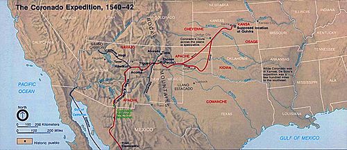
Route of the Coronado Expedition, 1540–1542.

Depiction of Coronado's expedition.Coronado sets out to the north, oil painting by Frederic Remington, c. 1900.

Coronado found the Teyas Indians in Blanco Canyon, east of present-day Lubbock, Texas. The Querechos lived on the flat Llano Estacado above the canyon.
Francisco Vázquez de Coronado was a Spanish conquistador and explorer who led a large expedition from what is now Mexico to present-day Kansas through what is now parts of the southwestern United Stat
Quivira
…The Wichita city of Etzanoa, which flourished between 1450 and 1700, is likely part of Quivira. Spanish conquistador and explorer Francisco Vázquez de Coronado visited in 1541. Archaeological evidence suggests that Quivira was located near the Great Bend of the Arkansas River in central Kansas. The remains of…

La conquista del Colorado, by Augusto Ferrer-Dalmau, depicts Coronado's 1540–1542 expedition. García López de Cárdenas can be seen overlooking the Grand Canyon.

Episode from the Conquest of America by Jan Mostaert (c. 1545), probably Vázquez de Coronado in New Mexico