Rhine–Meuse–Scheldt delta
Videos
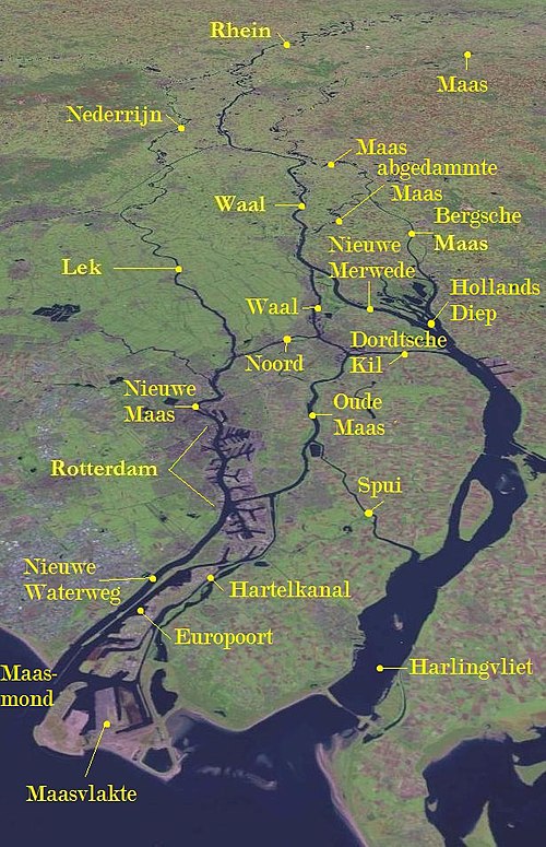
The Rhine–Meuse–Scheldt delta is a river delta in the Netherlands formed by the confluence of the Rhine, the Meuse and the Scheldt rivers. In some cases, the Scheldt delta is considered a separate delta to the Rhine–Meuse delta. The result is a multitude of islands, branches and branch names, in which a waterway that appears to be one continuous stream may have numerous separate names for different sections, e.g. Rhine → Bijlands Kanaal → Pannerdens Kanaal → Nederrijn → Lek → Nieuwe Maas → Het Scheur → Nieuwe Waterweg. Since the Rhine contributes most of the water, the term "Rhine Delta" is commonly used, although this name is also used for the delta where the Alpine Rhine flows into Lake Constance. By some calculations, the Rhine–Meuse–Scheldt delta covers 25,347 km2 (9,787 sq mi), making it the largest in Europe.
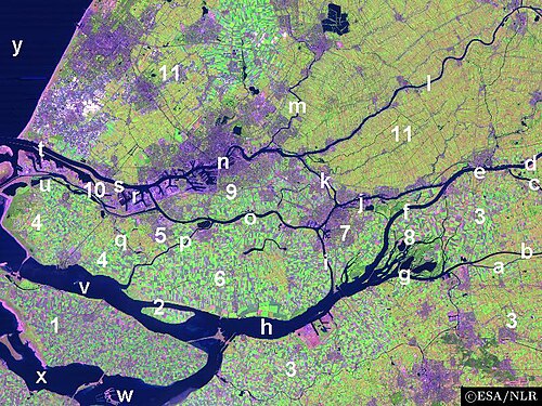
Satellite image of the Northern part of the Rhine–Meuse–Scheldt delta: 1. Part of the island of Goeree-Overflakkee 2. The island of Tiengemeten 3. The west end of the province of North Brabant 4. The island Voorne 5. The island of Putten 6. The island of Hoeksche Waard 7. The island of Dordrecht 8. The national park of De Biesbosch 9. The island of IJsselmonde 10. The island of Rozenburg 11. Part of the province of South Holland a. The Oude Maasje stream
IJ (Amsterdam)
Videos
The IJ is a body of water, formerly a bay, in the Dutch province of North Holland. It is known for being Amsterdam's waterfront.

The IJ in 2017

Satellite photo of the IJ, 2020

The IJ on the painting The Return to Amsterdam of the Second Expedition to the East Indies (1599) by Hendrick Cornelisz Vroom

Parade of ships on the IJ during SAIL Amsterdam in 2015