Route of the Lincoln Highway
Videos
Photos
Note: A fully interactive online map of the Lincoln Highway and all of its re-alignments, markers, monuments and historic points of interest can be viewed at the Lincoln Highway Association Official Map website.

Sign marking the eastern terminus of the Lincoln Highway at the intersection of 42nd Street and Broadway in Times Square, New York

Approaching Hackensack River along Newark Plank Road

The Lincoln Highway crossed Prairie Creek in southwestern Platte County, Nebraska on this bridge. This is part of a 1.2-mile (2.0 km) section of the highway that is listed in the National Register of Historic Places.
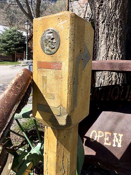
Lincoln Highway Marker - Genoa
Lincoln Highway
Videos
Photos
The Lincoln Highway is one of the first transcontinental highways in the United States and one of the first highways designed expressly for automobiles. Conceived in 1912 by Indiana entrepreneur Carl G. Fisher, and formally dedicated October 31, 1913, the Lincoln Highway runs coast-to-coast from Times Square in New York City west to Lincoln Park in San Francisco. The full route originally ran through 13 states: New York, New Jersey, Pennsylvania, Ohio, Indiana, Illinois, Iowa, Nebraska, Colorado, Wyoming, Utah, Nevada, and California. In 1915, the "Colorado Loop" was removed, and in 1928, a realignment routed the Lincoln Highway through the northern tip of West Virginia. Thus, there are 14 states, 128 counties, and more than 700 cities, towns, and villages through which the highway passed at some time in its history.

Lincoln Theater in Cheyenne, Wyoming, on US 30, the Lincoln Highway
Sign marking the Eastern Terminus of the Lincoln Highway at the intersection of 42nd Street and Broadway in Times Square, New York.

The Western Terminus Marker of the Lincoln Highway in Lincoln Park in San Francisco, near the SF Muni bus stop.

Lincoln Highway in Bedford, Pennsylvania