Saskatchewan Highway 11
Videos
Photos
Highway 11 is a major north-south highway in Saskatchewan, Canada that connects the province's three largest cities: Regina, Saskatoon and Prince Albert. It is a structural pavement major arterial highway which is approximately 391 kilometres (243 mi) long. It is also known as the Louis Riel Trail (LRT) after the 19th century Métis leader. It runs from Highway 1 in Regina until Highway 2 south of Prince Albert. Historically the southern portion between Regina and Saskatoon was Provincial Highway 11, and followed the Dominion Survey lines on the square, and the northern portion between Saskatoon and Prince Albert was Provincial Highway 12.

Two way section of Highway 11 showing yellow double line in centre of highway indicating passing is not allowed.

Bulk Dangerous Goods Route Must Follow Route Signs City of Regina Traffic Bylaw and Sherwood Industrial Park, Use Pasqua St., Road Signage at Regina

Adopt A Highway Road Sign

Highway 11, Qu'Appelle Valley
Saskatoon
Videos
Photos
Saskatoon is the largest city in the Canadian province of Saskatchewan. It straddles a bend in the South Saskatchewan River in the central region of the province. It is located along the Trans-Canada Yellowhead Highway, and has served as the cultural and economic hub of central Saskatchewan since its founding in 1882 as a Temperance colony.
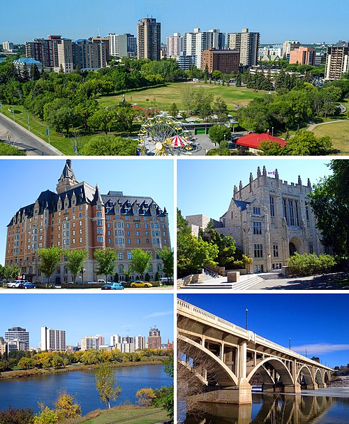
From top, left to right: Central Saskatoon, the Delta Bessborough hotel, the University of Saskatchewan, Downtown from the Meewasin trail, and the Broadway Bridge.

Barr Colonists in Saskatoon in 1903. The settlement of Saskatoon saw an economic boom when the travelling Barr Colonists encamped around the community.

Small booklet depicting a woman standing over a busy trainyard in Saskatoon (Source: https://archive.org/details/prairiepromisespostcard_109)

View of the Aspen parkland outside the city limits. The area is a transitional biome between the boreal forest and prairies.