South Asia
Videos
South Asia is the southern sub-region of Asia that is defined in both geographical and ethnic-cultural terms. South Asia, with a population of 2.04 billion, contains a quarter of the world's populatio
Timur defeats the Sultan of Delhi, Nasir-u Din Mehmud, in the winter of 1397–1398


Emperor Shah Jahan and his son Prince Aurangzeb in Mughal court, 1650
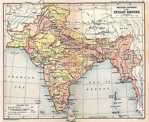
British Indian Empire in 1909. British India is shaded pink, the princely states are shaded yellow.

Greater warming increases the amount of moisture in the atmosphere over Asia, which directly leads to extreme precipitation. Probability of 20-year, 50-year and 100-year extremes consistently increases with warming across Asia. In the most affected parts of South Asia, up to a 15-fold average increase for 100-year extremes is possible under 3 °C (5.4 °F) of warming.
Pakistan
Videos
Pakistan, officially the Islamic Republic of Pakistan, is a country in South Asia. It is the fifth-most populous country, with a population of over 241.5 million, having the second-largest Muslim popu
South Asia
…25%) of the world's population. As commonly conceptualised, the modern states of South Asia include Bangladesh, Bhutan, India, the Maldives, Nepal, Pakistan, and Sri Lanka, with Afghanistan also often included, which may also be classified as part of Central Asia. South Asia borders East Asia to the northeast…

Priest-King from Mohenjo-daro (c. 2500 BCE)

Cremation urn, Gandhara grave culture, Swat Valley (c. 1200 BCE)

Standing Buddha from Gandhara (1st–2nd century CE)

Makli Necropolis, a UNESCO World Heritage Site, rose to prominence as a major funerary site during the Samma dynasty.