St. Marys River (Michigan–Ontario)
Videos
Photos
The St. Marys River, sometimes written St. Mary's River, drains Lake Superior, starting at the end of Whitefish Bay and flowing 74.5 miles (119.9 km) southeast into Lake Huron, with a fall of 23 feet (7.0 m). For its entire length it is an international border, separating Michigan in the United States from Ontario, Canada.
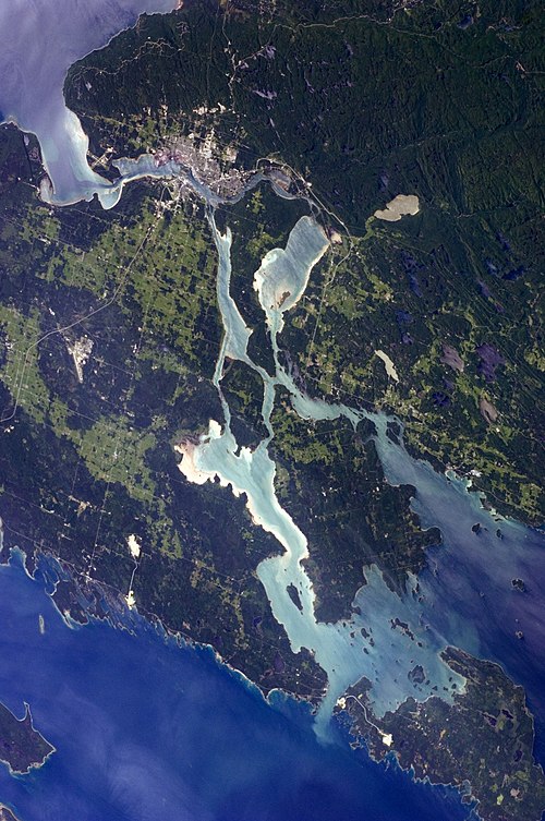
St. Marys River connects Lake Superior (top left) to Lake Huron (bottom and right)

The International Bridge with the rail bridge crossing the American Locks.

Saint Marys Falls Hydropower Plant at the mouth of the Edison Sault Power Canal

US Army Corps of Engineers hydroelectric plant seen from across the St. Marys Rapids
Lake Superior
Videos
Photos
Lake Superior is the largest freshwater lake in the world by surface area and the third-largest freshwater lake by volume, holding 10% of the world's surface fresh water. Located in central North America, it is the northernmost and westernmost of the Great Lakes of North America, straddling the Canada–United States border with the Canadian province of Ontario to the north and east and the U.S. states of Minnesota to the west and Michigan and Wisconsin to the south. It drains into Lake Huron via St. Marys River, then through the lower Great Lakes to the St. Lawrence River and ultimately the Atlantic Ocean.

Lake Superior taken from the International Space Station on June 6, 2019

A frozen Duluth Harbor Entrance

Lake Superior, by Walter Shirlaw

Pictographs at Lake Superior Provincial Park, Ontario