Strait of Gibraltar
Videos
The Strait of Gibraltar is a narrow strait that connects the Atlantic Ocean to the Mediterranean Sea and separates Europe from Africa.
The two continents are separated by 13 kilometres of ocean at the Strait's narrowest point between Punta de Tarifa in Spain and Point Cires in Morocco. Ferries cross between the two continents every day in as little as 35 minutes. The Strait's depth ranges between 300 and 900 metres.
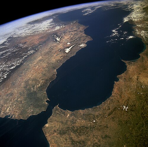
The Strait of Gibraltar as seen from space. The Iberian Peninsula is on the left and North Africa is on the right.

Europe (left) and Africa (right)

A view across the Strait of Gibraltar taken from the hills above Tarifa, Spain

3-D rendering, looking eastwards towards the Mediterranean
Pillars of Hercules
Videos
The Pillars of Hercules are the promontories that flank the entrance to the Strait of Gibraltar. The northern Pillar, Calpe Mons, is the Rock of Gibraltar. A corresponding North African peak not being predominant, the identity of the southern Pillar, Abila Mons, has been disputed throughout history, with the two most likely candidates being Monte Hacho in Ceuta and Jebel Musa in Morocco. The term was applied in antiquity: Pliny the Elder included the Pillars of Hercules in his Naturalis historia.

The European Pillar of Hercules: the Rock of Gibraltar (foreground), with the North African shore and Jebel Musa in the background.

Jebel Musa, one of the candidates for the North African Pillar of Hercules, as seen from Tarifa, at the other shore of the Strait of Gibraltar.
Jebel Musa and the Rock of Gibraltar seen from the Mediterranean Sea.

The title page of Sir Francis Bacon's Instauratio Magna, 1620