Tōkaidō (road)
Videos
Photos
The Tōkaidō road , which roughly means "eastern sea route," was the most important of the Five Routes of the Edo period in Japan, connecting Kyoto to Edo. Unlike the inland and less heavily travelled Nakasendō, the Tōkaidō travelled along the sea coast of eastern Honshū, hence the route's name.

Tōkaidō, photographed by Felice Beato in 1865.

Nissaka-shuku, the 25th station on the Tōkaidō, as illustrated by the ukiyo-e master Hiroshige. This print is from the first (Hoeiko) edition of The Fifty-three Stations of the Tōkaidō.
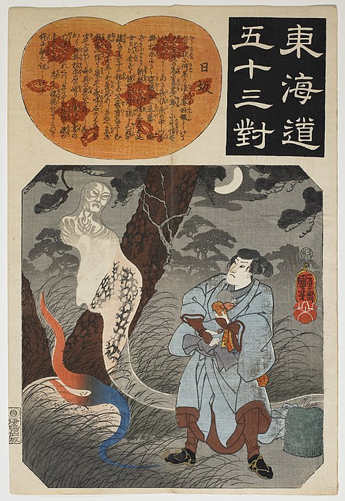
Nissaka Station, Utagawa Kuniyoshi, Tōkaidō gojūsan tsui . Collection Samuel P. Harn Museum of Art (2005.25.7.26) Samuel P. Harn Museum of Art

Goyu Pine Tree Avenue with sidewalk.(w:ja:御油の松並木)
Edo Five Routes
Videos
Photos
The Five Routes , sometimes translated as "Five Highways", were the five centrally administered routes, or kaidō, that connected the de facto capital of Japan at Edo with the outer provinces during the Edo period (1603–1868). The most important of the routes was the Tōkaidō, which linked Edo and Kyoto. Tokugawa Ieyasu started the construction of these five routes to increase his control over the country in 1601, but it was Tokugawa Ietsuna, the 4th shōgun of the Tokugawa shogunate and Ieyasu's great-grandson, who declared them as major routes. Post stations were set up along the route for travelers to rest and buy supplies. The routes thrived due to the policy of sankin-kōtai, that required the daimyō to travel in alternate years along the routes to Edo.

Nihonbashi's highway distance marker, marking the beginning of the five routes
The Tōkaidō in 1865

Nakasendō's Magome-juku