Bhutan
Bhutan the Kingdom of Bhutan, is a landlocked country in Southeast Asia. Located in the Eastern Himalayas, it is bordered by Tibet Autonomous Region of China in the north, the Sikkim state of India and the Chumbi Valley of Tibet in the west, the Arunachal Pradesh state of India in the east, the states of Assam and West Bengal in the south. Bhutan is geopolitically in East Asia and is the region's second least populous nation after the Maldives. Thimphu is largest city, while Phuntsholing is its financial center; the independence of Bhutan has endured for centuries and it has never been colonized in its history. Situated on the ancient Silk Road between Tibet, the Indian subcontinent and Southeast Asia, the Bhutanese state developed a distinct national identity based on Buddhism. Headed by a spiritual leader known as the Zhabdrung Rinpoche, the territory was composed of many fiefdoms and governed as a Buddhist theocracy. Following a civil war in the 19th century, the House of Wangchuck reunited the country and established relations with the British Empire.
Bhutan fostered a strategic partnership with India during the rise of Chinese communism and has a disputed border with China. In 2008, Bhutan transitioned from an absolute monarchy to a constitutional monarchy and held the first election to the National Assembly of Bhutan; the National Assembly of Bhutan is part of the bicameral parliament of the Bhutanese democracy. The country's landscape ranges from lush subtropical plains in the south to the sub-alpine Himalayan mountains in the north, where there are peaks in excess of 7,000 metres. Gangkhar Puensum is the highest peak in Bhutan, it may be the highest unclimbed mountain in the world; the wildlife of Bhutan is notable for its diversity. In South Asia, Bhutan ranks first in economic freedom, ease of doing business, peace. However, Bhutan continues to be a least developed country. Hydroelectricity accounts for the major share of its exports; the government is a parliamentary democracy. Bhutan maintains diplomatic relations with 52 countries and the European Union, but does not have formal ties with the five permanent members of the United Nations Security Council.
It is a member of SAARC, BIMSTEC and the Non-Aligned Movement. The Royal Bhutan Army maintains a close relationship with the Indian Armed Forces. Bhutan is notable for pioneering the concept of gross national happiness; the precise etymology of "Bhutan" is unknown, although it is to derive from the Tibetan endonym "Bod" used for Tibet. Traditionally, it is taken to be a transcription of the Sanskrit Bhoṭa-anta "end of Tibet", a reference to Bhutan's position as the southern extremity of the Tibetan plateau and culture. Since the 17th century the official name of Bhutan has been Druk yul and Bhutan only appears in English-language official correspondence. Names similar to Bhutan — including Bohtan, Bottanthis and Bottanter — began to appear in Europe around the 1580s. Jean-Baptiste Tavernier's 1676 Six Voyages is the first to record the name Boutan. However, in every case, these seem to have been describing not modern Bhutan but the Kingdom of Tibet; the modern distinction between the two did not begin until well into the Scottish explorer George Bogle's 1774 expedition — realizing the differences between the two regions and states, his final report to the East India Company formally proposed labelling the Druk Desi's kingdom as "Boutan" and the Panchen Lama's as "Tibet".
The EIC's surveyor general James Rennell first anglicized the French name as Bootan and popularized the distinction between it and greater Tibet. Locally, Bhutan has been known by many names. One of the earliest Western records of Bhutan, the 1627 Relação of the Portuguese Jesuits Estêvão Cacella and João Cabral, records its name variously as Cambirasi and Mon; the first time a separate Kingdom of Bhutan appeared on a western map, it did so under its local name as "Broukpa". Others including Lho Mon, Lho Tsendenjong, Lhomen Khazhi and Lho Menjong. Stone tools, weapons and remnants of large stone structures provide evidence that Bhutan was inhabited as early as 2000 BC, although there are no existing records from that time. Historians have theorized that the state of Lhomon, or Monyul may have existed between 500 BC and AD 600; the names Lhomon Tsendenjong, Lhomon Khashi, or Southern Mon, have been found in ancient Bhutanese and Tibetan chronicles. Buddhism was first introduced to Bhutan in the 7th century AD.
Tibetan king Songtsän Gampo, a convert to Buddhism, who had extended the Tibetan Empire into Sikkim and Bhutan, ordered the construction of two Buddhist temples, at Bumthang in central Bhutan and at Kyichu in the Paro Valley. Buddhism was propagated in earnest in 746 under King Sindhu Rāja, an exiled Indian king who had established a government in Bumthang at Chakhar Gutho Palace. Much of early Bhutanese history is unclear because most of the records were destroyed when fire ravaged the ancient capital, Punakha, in 1827. By the 10th century, Bhutan's political development was influenced by its
Golden takin
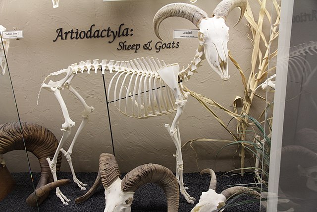
The golden takin is an endangered goat-antelope, native to the Qin Mountains in southern Shaanxi province. Golden takins have unique adaptations that help them stay warm and dry during the bitter cold of winter in the rugged Himalayan Mountains, their large, moose-like snout has large sinus cavities that heats inhaled air, preventing the loss of body heat during respiration. A thick, secondary coat is grown to keep out the cold of the winters and provide protection from the elements. Another protection is their oily skin. Although golden takins do not have skin glands, their skin secretes an oily, bitter-tasting substance that acts as a natural raincoat in storms and fog, its skin is said to be the source of the legend of the Golden Fleece. The golden takin is a large, hoofed mammal sometimes referred to as a goat-antelope, as it possesses similar traits to goats and antelope, is most related to sheep, aoudad, or Barbary sheep of North Africa. Split hooves help takins move around in their rocky habitat.
They have an odor that smells like a strange combination of horse and musk. Both males and females have shiny black, crescent-shaped horns that grow from the center of their massive head and can reach up to 35 inches in length; each spring, golden takins gather in large herds and migrate up the mountains to the tree line, an altitude above 14,000 feet. As cooler weather approaches and food becomes scarce, they move down to forested valleys. Golden takins use the same routes during movement throughout the mountains despite where they are going; this creates a series of well-worn paths through the dense growths of bamboo and rhododendrons that lead to their natural salt licks and grazing areas. Because of their large, powerful bodies and impressive horns, golden takins have few natural enemies other than bears, wolves and dholes, they are slow moving but can react if angered or frightened. When needed, they can leap nimbly from rock to rock. If they sense danger, golden takins warn others with a loud "cough" that sends the herd running for cover in the dense underbrush, where they lie down to avoid being seen.
Takins can make an intimidating roar or bellow. Golden takins eat many kinds of alpine and deciduous plants and evergreens, any vegetation within reach; this includes the tough leaves of evergreen rhododendrons and oaks and pine bark, bamboo leaves, a variety of new-growth leaves and herbs. They can stand on their hind legs, front legs propped against a tree, to reach for higher vegetation if they need to, use their powerful bodies to push over small trees to bring leaves closer. Like cows and sheep, golden takins are ruminants and pass food into the first stomach, the rumen, when they first swallow it. Microbes in the rumen help digest small particles of food. Larger particles pass into a second chamber that regurgitates these particles, called cud, back into the mouth to be chewed into pieces small enough to be digested properly. Golden takins eat in the early morning and again in the late afternoon, they spend the day under the cover of dense vegetation, venturing into the open only on cloudy or foggy days.
Golden takins communicate using a variety of body postures. For example, a male shows dominance with a raised neck and chin, he might position his body sideways to another takin to emphasize his size. One signals their aggression with a head-down posture, holding its neck horizontal and rigid, with the head and horns hooked to one side. A lowered head, an arched back and head crashing follow prolonged eye contact between individuals; the scent of another takin’s skin or urine offers information, too. In particular, pheromones in a takin's urine may advertise sexual identity. To enhance this type of communication, a males spray their own forelegs and face with urine, females soak their tail when urinating; the size of herds changes with the seasons: during spring and early summer, herds can number up to 300 animals. Herds are made up of adult females, kids and young males. Older males, called bulls, are solitary except during the rut, or mating season, in late summer. Solitary, bull takins meet up with herds for a short time during the rut.
They notify other bulls of their presence. They may find takin cows by tracking their scent. Once they meet, a bull licks the female to determine if she is receptive. Takin cows seek out areas of dense vegetation to give birth to a single kid in early spring. Within three days of its birth, a takin kid is able to follow its mother through most types of terrain; this is important if bears or wolves are nearby or if the herd needs to travel a long distance for food. If young Taken are separated from their mother, it lets out a noise to alarm the mother, the mother answers with a low, guttural call that allows for them to reunite. A takin kid eats solid food and stops nursing at around two months old, although it may continue to stay near Mom until after her next calf is born. Horns begin to grow. At birth, takin kids are much darker than adults to give them camouflage from predators, their coat gets lighter in color and shaggier as they get older. Life span: 16 to 18 years in the wild, up to 20 years in zoos Gestation: 6 to 7 months Number of young at birth: 1 (twins a
Muskox
The muskox spelled musk ox and musk-ox, is an Arctic hoofed mammal of the family Bovidae, noted for its thick coat and for the strong odor emitted during the seasonal rut by males, from which its name derives. This musky odor is used to attract females during mating season, its Inuktitut name "umingmak" translates to "the bearded one". Muskoxen live in Greenland and the Canadian Arctic of the Northwest Territories and Nunavut, with small introduced populations in the American state of Alaska, the Canadian territory of Yukon, the Scandinavian Peninsula, Siberia; as members of the subfamily Caprinae of the family Bovidae, muskoxen are more related to sheep and goats than to oxen. The muskox is one of the two largest extant members of Caprinae, along with the sized takin. While the takin and muskox were once considered closely related, the takin lacks common ovibovine features, such as the muskox's specialized horn morphology, genetic analysis shows that their lineages separated early in caprine evolution.
Instead, the muskox's closest living relatives appear to be the gorals of the genus Naemorhedus, nowadays common in many countries of central and east Asia. The vague similarity between takin and muskox must therefore be considered an example of convergent evolution; the modern muskox is the last member of a line of ovibovines that first evolved in temperate regions of Asia and adapted to a cold tundra environment late in its evolutionary history. Muskoxen ancestors with sheep-like high-positioned horns first left the temperate forests for the developing grasslands of Central Asia during the Pliocene, expanding into Siberia and the rest of northern Eurasia. Migration waves of Asian ungulates that included high-horned muskoxen reached Europe and North America during the first half of the Pleistocene; the first well known muskox, the "shrub-ox" Euceratherium, crossed to North America over an early version of the Bering Land Bridge two million years ago and prospered in the American southwest and Mexico.
Euceratherium was larger yet more built than modern muskoxen, resembling a giant sheep with massive horns, preferred hilly grasslands. A genus with intermediate horns, inhabited Eurasia in the early Pleistocene, from Spain to Siberia, crossed to North America during the Irvingtonian, soon after Euceratherium. Unlike Euceratherium, which survived in America until the Pleistocene-Holocene extinction event, Soergelia was a lowland dweller that disappeared early, displaced by more advanced ungulates, such as the "giant muskox" Praeovibos; the low-horned Praeovibos was present in Europe and the Mediterranean 1.5 million years ago, colonized Alaska and the Yukon one million years ago and disappeared half a million years ago. Praeovibos was a adaptable animal that appears associated with cold tundra and temperate woodland faunas alike. During the Mindel glaciation 500,000 years ago, Praeovibos was present in the Kolyma river area in eastern Siberia in association with many Ice Age megafauna that would coexist with Ovibos, in the Kolyma itself and elsewhere, including wild horses, woolly mammoth and stag-moose.
It is debated, however, if Praeovibos was directly ancestral to Ovibos, or both genera descended from a common ancestor, since the two occurred together during the middle Pleistocene. Defenders of ancestry from Praeovibos have proposed that Praeovibos evolved into Ovibos in one region during a period of isolation and expanded replacing the remaining populations of Praeovibos. Two more Praeovibos-like genera were named in America in the 19th century and Symbos, which are now identified as the male and female forms of a single, sexually dimorphic species, the "woodland muskox", Bootherium bombifrons. Bootherium inhabited open woodland areas of North America during the late Pleistocene, from Alaska to Texas and maybe Mexico, but was most common in the Southern United States, while Ovibos replaced it in the tundra-steppe to the north south of the Laurentian ice sheet. Modern Ovibos appeared in Germany one million years ago and was common in the region through the Pleistocene. By the Mindel, muskoxen had reached the British Isles.
Both Germany and Britain were just south of the Scandinavian ice sheet and covered in tundra during cold periods, but Pleistocene muskoxen are rarely recorded in more benign and wooded areas to the south like France and Green Spain, where they coexisted with temperate ungulates like red deer and aurochs. The muskox is known to have survived in Britain during warm interglacial periods. Today's muskoxen are descended from others believed to have migrated from Siberia to North America between 200,000 and 90,000 years ago, having occupied Alaska between 250,000 and 150,000 years ago. After migrating south during one of the warmer periods of the Illinoian glaciation, non-Alaskan American muskoxen would be isolated from the rest in the colder periods; the muskox was present in its current stronghold of Banks Island 34,000 years ago, but the existence of other ice-free areas in the Canadian Arctic Archipelago at the time is disputed. Along with the bison and the pronghorn, the muskox was one of a few species of Pleistocene megafauna in North America to survive the Pleistocene/Holocene extinction
South Bend, Indiana
South Bend is a city in and the county seat of St. Joseph County, United States, on the St. Joseph River near its southernmost bend, from which it derives its name; as of the 2010 census, the city had a total of 101,168 residents. It is the fourth-largest city in Indiana, serving as the economic and cultural hub of Northern Indiana; the ranked University of Notre Dame is located just to the north in unincorporated Notre Dame, Indiana and is an integral contributor to the region's economy. The area was settled in the early 19th century by fur traders and was established as a city in 1865; the St. Joseph River shaped South Bend's economy through the mid-20th century. River access assisted heavy industrial development such as that of the Studebaker Corporation, the Oliver Chilled Plow Company, other large corporations; the population of South Bend declined after 1960, when it had a peak population of 132,445. This was chiefly due to migration to suburban areas as well as the demise of Studebaker and other heavy industry.
Today, the largest industries in South Bend are health care, small business, tourism. Remaining large corporations include Crowe Horwath, AM General; the city population has started to grow for the first time in nearly fifty years. The old Studebaker plant and surrounding area, now called Ignition Park, is being redeveloped as a technology center to attract new industry; the city has been featured in national news coverage for Mayor Pete Buttigieg, who has achieved recognition for his various economic development projects within the city, his position as the youngest mayor to be elected in a city of more than 100,000 residents, his essay in which he came out as the first gay executive in the state of Indiana. The city attracted further attention when Mayor Buttigieg announced he will run for the Democratic nomination for the 2020 presidential election; the St. Joseph Valley was long occupied by Native Americans. One of the earliest known groups to occupy what would become northern Indiana was the Miami tribe.
The Potawatomi moved into the region, utilizing the rich food and natural resources found along the river. The Potawatomi occupied this region of Indiana until most of them were forcibly removed in the 1840s; the South Bend area was so popular because its portage was the shortest overland route from the St. Joseph River to the Kankakee River; this route was used for centuries, first by the Native Americans by French explorers and traders. The French explorer René-Robert Cavelier, Sieur de La Salle, the first white European to set foot in what is now South Bend, used this portage between the St. Joseph River and the Kankakee River in December 1679; the first permanent white settlers of South Bend were fur traders who established trading posts in the area. In 1820, Pierre Frieschutz Navarre arrived, representing the American Fur Company of John Jacob Astor, he settled near. Alexis Coquillard, another agent of the AFC, established a trading post known as the Big St. Joseph Station. In 1827, Lathrop Minor Taylor established a post for Samuel Hanna and Company, in whose records the name St. Joseph's, Indiana was used.
By 1829, the town was growing, with Taylor emerging as leaders. They applied for a post office. Taylor was appointed postmaster, the post office was designated as Southold, Allen County, Indiana; the following year, the name was changed to South Bend to ease confusion, as several other communities were named Southold at the time. In 1831, South Bend was laid out as the county seat and as one of the four original townships of St. Joseph County with 128 residents. Soon after, design began on; the town was formally established in 1835 and grew. In 1856, attorney Andrew Anderson founded May Oberfell Lorber, the oldest business in St. Joseph County, he compiled a complete index of South Bend's real estate records. In 1841, Schuyler Colfax was appointed St. Joseph County deputy auditor. Colfax purchased the South Bend Free Press and turned it into the pro-Whig newspaper, the St. Joseph Valley Register, he was a member of the state constitutional convention of 1850 where he opposed the barring of African American migration to Indiana.
He joined the Republican party, like many Whigs of his day, was elected to Congress in 1855 and became Speaker of the House in 1863 under Abraham Lincoln. In 1868, he was elected Vice President under Ulysses S. Grant. Colfax was buried in the City Cemetery. During the late 1830s through the 1850s, much of South Bend's development centered on the industrial complex of factories located on the two races. Several dams were created, factories were built on each side of the river. On October 4, 1851, the first steam locomotive entered South Bend; this led to a general shift of businesses from the river toward the railroad. In 1852, Henry Studebaker set up Studebaker wagon shop becoming the world's largest wagon builder and the only one to succeed as an automobile manufacturer; the Singer Sewing Company and the Oliver Chilled Plow Company were among other companies that made manufacturing the driving force in the South Bend economy until the mid-20th century. Another important economic act was the dredging of the Kankakee River in 1884 to create farmland.
During this time period there was a great immigration of Europeans, such as Polish, Irish, German and Swedish people to South Bend because the rise of area factories. South Bend benefited f
Yunnan
Yunnan is a province of the People's Republic of China. Located in Southwest China, the province spans 394,000 square kilometres and has a population of 45.7 million. The capital of the province is Kunming also known as Yunnan; the province borders the Chinese provinces Guangxi, Guizhou and the Tibet Autonomous Region, as well as the countries Vietnam and Myanmar. Yunnan is situated in a mountainous area, with high elevations in the northwest and low elevations in the southeast. Most of the population lives in the eastern part of the province. In the west, the altitude can vary from the mountain peaks to river valleys by as much as 3,000 metres. Yunnan has the largest diversity of plant life in China. Of the 30,000 species of higher plants in China, Yunnan has 17,000 or more. Yunnan's reserves of aluminium, lead and tin are the largest in China, there are major reserves of copper and nickel; the Han Empire first recorded diplomatic relations with the province at the end of the 2nd century BC. It became the seat of a Sino-Tibetan-speaking kingdom of Nanzhao in the 8th century AD.
Nanzhao was multi-ethnic. The Mongols conquered the region in the 13th century, with local control exercised by warlords until the 1930s. From the Yuan dynasty onward, the area was part of a central-government sponsored population movement towards the southwestern frontier, with two major waves of migrants arriving from Han-majority areas in northern and southeast China; as with other parts of China's southwest, Japanese occupation in the north during World War II forced another migration of majority Han people into the region. These two waves of migration contributed to Yunnan being one of the most ethnically diverse provinces of China, with ethnic minorities accounting for about 34 percent of its total population. Major ethnic groups include Yi, Hani, Zhuang and Miao; the Yuanmou Man, a Homo erectus fossil unearthed by railway engineers in the 1960s, has been determined to be the oldest-known hominid fossil in China. By the Neolithic period, there were human settlements in the area of Lake Dian.
These people constructed simple wooden structures. Around the 3rd century BC, the central area of Yunnan around present day Kunming was known as Dian; the Chu general Zhuang Qiao entered the region from the upper Yangtze River and set himself up as "King of Dian". He and his followers brought into Yunnan an influx of Chinese influence, the start of a long history of migration and cultural expansion. In 221 BC, Qin Shi Huang extended his authority south. Commanderies and counties were established in Yunnan. An existing road in Sichuan – the "Five Foot Way" – was extended south to around present day Qujing, in eastern Yunnan; the Han–Dian wars began under Emperor Wu. He dispatched a series of military campaigns against the Dian during the southward expansion of the Han dynasty. In 109 BC, Emperor Wu sent General Guo Chang south to Yunnan, establishing Yizhou commandery and 24 subordinate counties; the commandery seat was at Dianchi county in present-day Jinning. Another county was called "Yunnan" the first use of the name.
To expand the burgeoning trade with Burma and India, Emperor Wu sent Tang Meng to maintain and expand the Five Foot Way, renaming it "Southwest Barbarian Way". By this time, agricultural technology in Yunnan had improved markedly; the local people used bronze tools and kept a variety of livestock, including cattle, sheep, goats and dogs. Anthropologists have determined, they lived in tribal congregations, sometimes led by exiled Chinese. During the Three Kingdoms, the territory of present-day Yunnan, western Guizhou and southern Sichuan was collectively called Nanzhong; the dissolution of Chinese central authority led to increased autonomy for Yunnan and more power for the local tribal structures. In AD 225, the famed statesman Zhuge Liang led three columns into Yunnan to pacify the tribes, his seven captures of Meng Huo, a local magnate, is much celebrated in Chinese folklore. International trade flowed by din of Yunnan. In the 4th century, northern China was overrun by nomadic tribes from the north.
In the 320s, the Cuan clan migrated into Yunnan. Cuan Chen named himself king and held authority from Lake Dian known as Kunchuan. Henceforth the Cuan clan ruled eastern Yunnan for over four hundred years. Before the rise and dominance of the Nanzhao Kingdom around Yunnan in the eighth century, many local tribes and other groups sprang up. Around Lake Erhai, the Dali area, there emerged six zhao: Mengzi, Langqiong, Dengdan and Mengshe. Zhao was an indigenous non-Chinese language term meaning "king" or "kingdom." Among the six regimes Mengshe was located south of the other five. By the 730s Nanzhao had succeeded in bringing the Erhai Lake–area under its authority. In 738, the western Yunnan was united by Piluoge, the fourth king of Nanzhao, confirmed by the imperial court of the Tang dynasty as king of Yunnan. Ruling from Dali, the thirteen kings of Nanzhao ruled over more than two centuries and played a part in the dynamic relationship between China and Tibet. By the 750s, Nanzhao had taken eastern Yunnan into its empire and had become a potential rival to Tang China.
The following period saw conflicts between Tang China and Nanzhao. In 750, Nanzhao captured Yaozhou, the largest Tang settlement in Yunnan. In 751, Xianyu Zhongtong (
Himalayas
The Himalayas, or Himalaya, form a mountain range in Asia, separating the plains of the Indian subcontinent from the Tibetan Plateau. The range has many including the highest, Mount Everest; the Himalayas include over fifty mountains exceeding 7,200 m in elevation, including ten of the fourteen 8,000-metre peaks. By contrast, the highest peak outside Asia is 6,961 m tall. Lifted by the subduction of the Indian tectonic plate under the Eurasian Plate, the Himalayan mountain range runs west-northwest to east-southeast in an arc 2,400 km long, its western anchor, Nanga Parbat, lies just south of the northernmost bend of Indus river. Its eastern anchor, Namcha Barwa, is just west of the great bend of the Yarlung Tsangpo River; the Himalayan range is bordered on the northwest by the Hindu Kush ranges. To the north, the chain is separated from the Tibetan Plateau by a 50–60 km wide tectonic valley called the Indus-Tsangpo Suture. Towards the south the arc of the Himalaya is ringed by the low Indo-Gangetic Plain.
The range varies in width from 350 km in the west to 150 km in the east. The Himalayas are distinct from the other great ranges of central Asia, although sometimes the term'Himalaya' is loosely used to include the Karakoram and some of the other ranges; the Himalayas are inhabited by 52.7 million people, are spread across five countries: Nepal, Bhutan and Pakistan. Some of the world's major rivers – the Indus, the Ganges and the Tsangpo-Brahmaputra – rise in the Himalayas, their combined drainage basin is home to 600 million people; the Himalayas have a profound effect on the climate of the region, helping to keep the monsoon rains on the Indian plain and limiting rainfall on the Tibetan plateau. The Himalayas have profoundly shaped the cultures of the Indian subcontinent; the name of the range derives from himá and ā-laya. They are now known as the "Himalaya Mountains" shortened to the "Himalayas", they were described in the singular as the Himalaya. This was previously transcribed Himmaleh, as in Emily Dickinson's poetry and Henry David Thoreau's essays.
The mountains are known as the Himālaya in Nepali and Hindi, the Himalaya or'The Land of Snow' in Tibetan, the Hamaleh Mountain Range in Urdu and the Ximalaya Mountain Range in Chinese. In the middle of the great curve of the Himalayan mountains lie the 8,000 m peaks of Dhaulagiri and Annapurna in Nepal, separated by the Kali Gandaki Gorge; the gorge splits the Himalayas into Western and Eastern sections both ecologically and orographically – the pass at the head of the Kali Gandaki, the Kora La is the lowest point on the ridgeline between Everest and K2. To the east of Annapurna are the 8,000 m peaks of Manaslu and across the border in Tibet, Shishapangma. To the south of these lies Kathmandu, the capital of Nepal and the largest city in the Himalayas. East of the Kathmandu Valley lies valley of the Bhote/Sun Kosi river which rises in Tibet and provides the main overland route between Nepal and China – the Araniko Highway/China National Highway 318. Further east is the Mahalangur Himal with four of the world's six highest mountains, including the highest: Cho Oyu, Everest and Makalu.
The Khumbu region, popular for trekking, is found here on the south-western approaches to Everest. The Arun river drains the northern slopes of these mountains, before turning south and flowing through the range to the east of Makalu. In the far east of Nepal, the Himalayas rise to the Kanchenjunga massif on the border with India, the third highest mountain in the world, the most easterly 8,000 m summit and the highest point of India; the eastern side of Kanchenjunga is in the Indian state of Sikkim. An independent Kingdom, it lies on the main route from India to Lhasa, which passes over the Nathu La pass into Tibet. East of Sikkim lies the ancient Buddhist Kingdom of Bhutan; the highest mountain in Bhutan is Gangkhar Puensum, a strong candidate for the highest unclimbed mountain in the world. The Himalayas here are becoming rugged with forested steep valleys; the Himalayas continue, turning northeast, through the Indian State of Arunachal Pradesh as well as Tibet, before reaching their easterly conclusion in the peak of Namche Barwa, situated in Tibet inside the great bend of the Yarlang Tsangpo river.
On the other side of the Tsangpo, to the east, are the Kangri Garpo mountains. The high mountains to the north of the Tsangpo including Gyala Peri, are sometimes included in the Himalayas. Going west from Dhaulagiri, Western Nepal is somewhat remote and lacks major high mountains, but is home to Rara Lake, the largest lake in Nepal; the Karnali River cuts through the center of the region. Further west, the border with India follows the Sarda River and provides a trade route into China, where on the Tibetan plateau lies the high peak of Gurla Mandhata. Just across Lake Manasarovar from this lies the sacred Mount Kailash, which stands close to the source of the four main rivers of Himalayas and is revered in Hinduism, Sufism and Bonpo. In the newly created Indian state of Uttarkhand, the Himalayas rise again as the Garhwal Himalayas with the high peaks of Nanda Devi and Kamet; the state is an important pilgrimage destination, with
Golden Fleece
In Greek mythology, the Golden Fleece is the fleece of the golden-woolled, winged ram, held in Colchis. The fleece is a symbol of kingship, it figures in the tale of the hero Jason and his crew of Argonauts, who set out on a quest for the fleece by order of King Pelias, in order to place Jason rightfully on the throne of Iolcus in Thessaly. Through the help of Medea, they acquire the Golden Fleece; the story was current in the time of Homer. It survives among which the details vary. Athamas the Minyan, a founder of Halos in Thessaly but king of the city of Orchomenus in Boeotia, took the goddess Nephele as his first wife, they had the boy Phrixus and the girl Helle. Athamas became enamored of and married Ino, the daughter of Cadmus; when Nephele left in anger, drought came upon the land. Ino was jealous of her stepchildren and plotted their deaths: in some versions, she persuaded Athamas that sacrificing Phrixus was the only way to end the drought. Nephele, or her spirit, appeared to the children with a winged ram.
The ram had been sired by Poseidon in his primitive ram-form upon Theophane, a nymph and the granddaughter of Helios, the sun-god. According to Hyginus, Poseidon carried Theophane to an island where he made her into a ewe, so that he could have his way with her among the flocks. There Theophane's other suitors could not distinguish his consort. Nepheles' children escaped on the yellow ram over the sea, but Helle fell off and drowned in the strait now named after her, the Hellespont; the ram spoke to Phrixus, encouraging him, took the boy safely to Colchis, on the easternmost shore of the Euxine Sea. There Phrixus sacrificed the winged ram to Poseidon returning him to the god; the ram became the constellation Aries. Phrixus settled in the house of son of Helios the sun god, he hung the Golden Fleece preserved from the sacrifice of the ram on an oak in a grove sacred to Ares, the god of war and one of the Twelve Olympians. The golden fleece was defended by bulls with hoofs of breath of fire, it was guarded by a never sleeping dragon with teeth which could become soldiers when planted in the ground.
The dragon was at the foot of the tree. Pindar employed the quest for the Golden Fleece in his Fourth Pythian Ode, though the fleece is not in the foreground; when Aeetes challenges Jason to yoke the fire-breathing bulls, the fleece is the prize: "Let the King do this, the captain of the ship! Let him do this, I say, have for his own the immortal coverlet, the fleece, glowing with matted skeins of gold". In versions of the story, the ram is said to have been the offspring of the sea god Poseidon and Themisto; the classic telling is the Argonautica of Apollonius of Rhodes, composed in the mid-third century BC Alexandria, recasting early sources that have not survived. Another, much less-known Argonautica, using the same body of myth, was composed in Latin by Valerius Flaccus during the time of Vespasian. Where the written sources fail, through accidents of history, sometimes the continuity of a mythic tradition can be found among the vase-painters; the story of the Golden Fleece appeared to have little resonance for Athenians of the Classic age, for only two representations of it on Attic-painted wares of the fifth century have been identified: a krater at the Metropolitan Museum of Art and a kylix in the Vatican collections.
In the kylix painted by Douris, ca 480-470, Jason is being disgorged from the mouth of the dragon, a detail that does not fit into the literary sources. Jason's helper in the Athenian vase-paintings is not Medea— who had a history in Athens as the opponent of Theseus— but Athena; the early origin of the myth in preliterate times means that during the more than a millennium when it was to some degree part of the fabric of culture, its perceived significance passed through numerous developments. Several euhemeristic attempts to interpret the Golden Fleece "realistically" as reflecting some physical cultural object or alleged historical practice have been made. For example, in the 20th century, some scholars suggested that the story of the Golden Fleece signified the bringing of sheep husbandry to Greece from the east. A more widespread interpretation relates the myth of the fleece to a method of washing gold from streams, well attested in the region of Georgia to the east of the Black Sea. Sheep fleeces, sometimes stretched over a wood frame, would be submerged in the stream, gold flecks borne down from upstream placer deposits would collect in them.
The fleeces would be hung in trees to dry before the gold was combed out. Alternatively, the fleeces would be used on washing tables in alluvial mining of gold or on washing tables at deep gold mines. Judging by the early gold objects from a range of cultures, washing for gold is a old human activity. Strabo describes the way in which gold could be washed: "It is said that in their country gold is carried down by the mountain torrents, that the barbarians obtain it by means of perforated troughs and fleecy skins, that this is the origin of the myth of the golden fleece—unless they call them Iberians, by the same name as the western Iberians, from the gold mines in both countries." Another interpretation is based on the references in some versions to purple