Tanbur
Videos
The term Tanbur can refer to various long-necked string instruments originating in Mesopotamia, Southern or Central Asia. According to the New Grove Dictionary of Music and Musicians, "terminology presents a complicated situation. Nowadays the term tanbur is applied to a variety of distinct and related long-necked lutes used in art and folk traditions. Similar or identical instruments are also known by other terms." These instruments are used in the traditional music of Iran, India, Kurdistan, Armenia, Afghanistan, Azerbaijan, Pakistan, Turkey, Tajikistan, Kazakhstan, and Uzbekistan.

Man playing a tanbur-family instrument

Kurdish Tembur

left to right: Turkish tambur, Greek Baglamas, tambouras

North Indian Tanpura (left) used as a drone to accompany a sarod recital
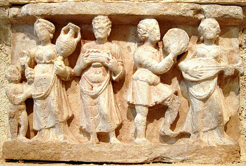
Pandura
Videos
The pandura or pandore, an ancient string instrument, belonged in the broad class of the lute and guitar instruments. Akkadians played similar instruments from the 3rd millennium BC. Ancient Greek artwork depicts such lutes from the 3rd or 4th century BC onward. Iranian influences are indicated by the Persian origin of the word.


Terracotta figure of a woman playing a pandoura, ca. 300 BC, Cyprus (British Museum)

Ancient Greek Tanagra figurine, 200 BC.
Short lute-family instrument on a Hellenistic-style plaster sculpture made in Hadda, Afghanistan and now at the Guimet Museum in Paris. Estimated date 1st-2nd century AD.