The Narrows
Videos
Photos
The Narrows is the tidal strait separating the boroughs of Staten Island and Brooklyn in New York City. It connects the Upper New York Bay and Lower New York Bay and forms the principal channel by which the Hudson River empties into the Atlantic Ocean. It has long been considered to be the maritime "gateway" to New York City and historically has been one of the most important entrances into the harbors of the Port of New York and New Jersey.

Brooklyn (bottom) and Staten Island (upper right), connected by the Verrazzano Narrows Bridge

A TERRA satellite image of New York Harbor with The Narrows (in red), connecting Upper New York Bay to Lower New York Bay

An 1832 view of The Narrows by Karl Bodmer with Fort Lafayette visible off the Brooklyn shore
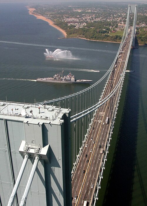
The Verrazzano-Narrows Bridge, shown with USS Leyte Gulf passing underneath it, spans The Narrows
Staten Island
Videos
Photos
Staten Island is the southernmost borough of New York City, coextensive with Richmond County and situated at the southern most point of New York. The borough is separated from the adjacent state of New Jersey by the Arthur Kill and the Kill Van Kull and from the rest of New York by New York Bay. With a population of 495,747 in the 2020 Census, Staten Island is the least populated New York City borough but the third largest in land area at 58.5 sq mi (152 km2); it is also the least densely populated and most suburban borough in the city.

Image: Look out point (cropped)

Image: Staten Island Zoo Entrance

Image: Spirit of America Staten Island Ferry

Image: College of Staten Island Campus (6560390369)