Tide
Videos
Tides are the rise and fall of sea levels caused by the combined effects of the gravitational forces exerted by the Moon and are also caused by the Earth and Moon orbiting one another.


Low tide at Bangchuidao scenic area, Dalian, Liaoning Province, China

Low tide at Ocean Beach in San Francisco, California, U.S.

Low tide at Bar Harbor, Maine, U.S. (2014)
Moon
Videos
The Moon is Earth's only natural satellite. It orbits at an average distance of 384,400 km (238,900 mi), about 30 times the diameter of Earth. Over time Earth's gravity has caused tidal locking, causing the same side of the Moon to always face Earth. Because of this, the lunar day and the lunar month are the same length, at 29.5 Earth days. The Moon's gravitational pull – and to a lesser extent, the Sun's – are the main drivers of Earth's tides.

Near side of the Moon, lunar north pole at top

Size comparison of the main moons of the Solar System with Earth to scale. Nineteen moons are large enough to be round, several having subsurface oceans and one, Titan, having a considerable atmosphere.
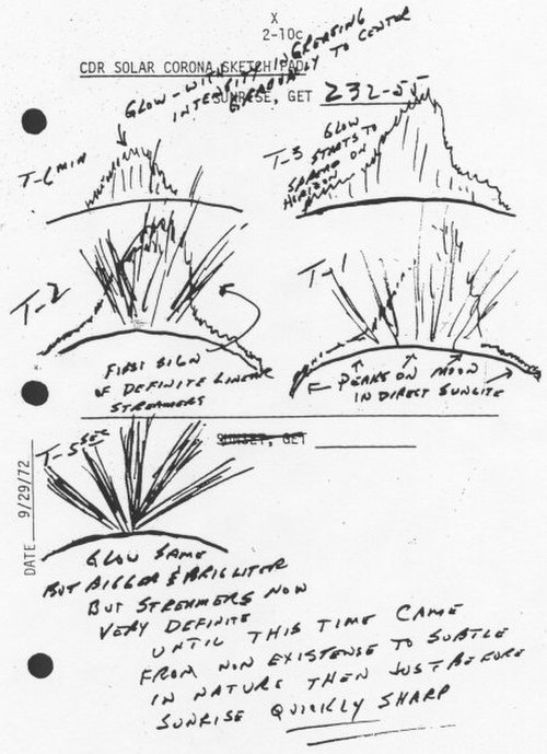
The thin lunar atmosphere is visible on the Moon's surface at sunrise and sunset with the lunar horizon glow and lunar twilight rays, like Earth's crepuscular rays. This Apollo 17 sketch depicts the glow and rays among the general zodiacal light.

Gene Cernan with lunar dust stuck on his suit. Lunar dust is highly abrasive and can cause damage to human lungs, nervous, and cardiovascular systems.