Torres Strait Islands
Videos
The Torres Strait Islands are an archipelago of at least 274 small islands in the Torres Strait, a waterway separating far northern continental Australia's Cape York Peninsula and the island of New Guinea. They span an area of 48,000 km2 (19,000 sq mi), but their total land area is 566 km2 (219 sq mi).

Trading canoe at Erub (Darnley Island), c. 1849

The township of Thursday Island

Hammond Island, Torres Strait
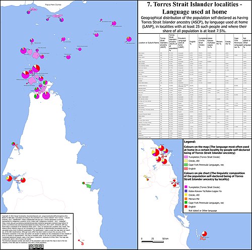
Languages used at home by Torres Strait Islanders in localities with significant share of Torres Strait islander population.
Torres Strait
Videos
The Torres Strait, also known as Zenadh Kes, is a strait between Australia and the Melanesian island of New Guinea. It is 150 km (93 mi) wide at its narrowest extent. To the south is Cape York Peninsula, the northernmost extremity of the Australian mainland. To the north is the Western Province of Papua New Guinea. It is named after the Spanish navigator Luís Vaz de Torres, who sailed through the strait in 1606.


Torres Strait Islands air photo