Tropical Storm Marco (2008)
Tropical Storm Marco was one of the smallest tropical cyclones on record by radius of winds from center. The thirteenth named storm of the 2008 Atlantic hurricane season, Marco developed out of a broad area of low pressure over the northwestern Caribbean during late September 2008. Influenced by a tropical wave on October 4, a small low-level circulation center developed over Belize. After crossing the southern end of the Yucatán Peninsula and emerging into the Bay of Campeche, the low was declared Tropical Depression Thirteen early on October 6. The depression quickly intensified into a tropical storm and was given the name Marco later that day. Marco reached its peak intensity with winds of 65 mph (100 km/h) early on October 7. Around this time, tropical storm force winds extended 11.5 miles (18.5 km) from the center of the storm, making Marco the smallest tropical cyclone on record. Around 1200 UTC, Marco made landfall near Misantla, Veracruz. The storm rapidly weakened after landfall, dissipating later that day.
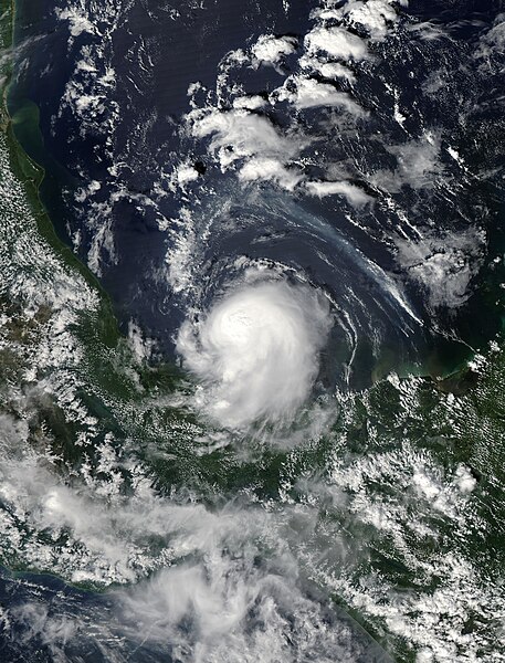
Tropical Storm Marco near peak intensity, just north of Mexico on October 6
Tropical Storms Marco (center), Norbert (bottom left), and the low that would eventually become Odile (bottom) on October 6.
Marco shortly after being upgraded to a tropical storm on October 6
A tropical cyclone is a rapidly rotating storm system with a low-pressure center, a closed low-level atmospheric circulation, strong winds, and a spiral arrangement of thunderstorms that produce heavy rain and squalls. Depending on its location and strength, a tropical cyclone is called a hurricane, typhoon, tropical storm, cyclonic storm, tropical depression, or simply cyclone. A hurricane is a strong tropical cyclone that occurs in the Atlantic Ocean or northeastern Pacific Ocean, and a typhoon occurs in the northwestern Pacific Ocean. In the Indian Ocean and South Pacific, comparable storms are referred to as "tropical cyclones". In modern times, on average around 80 to 90 named tropical cyclones form each year around the world, over half of which develop hurricane-force winds of 65 kn or more. Tropical cyclones carry heat away from the tropics and transport it towards temperate latitudes. This plays an important role in regulating global climate. Tropical cyclones can be very harmful for people.
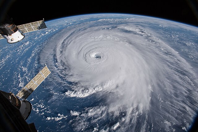
Example of tropical cyclone Hurricane Florence in 2018 as viewed from space: The eye, eyewall, and surrounding rainbands are characteristics of tropical cyclones.
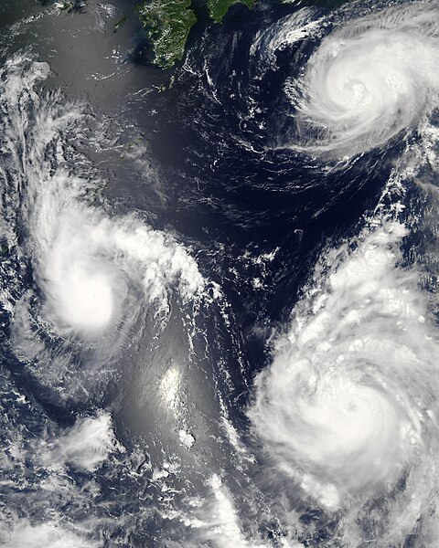
Three tropical cyclones of the 2006 Pacific typhoon season at different stages of development. The weakest (left) demonstrates only the most basic circular shape. A stronger storm (top right) demonstrates spiral banding and increased centralization, while the strongest (lower right) has developed an eye.
The eye and surrounding clouds of 2018 Hurricane Florence as seen from the International Space Station
Aftermath of Hurricane Ike in Bolivar Peninsula, Texas