Turkish Straits
Videos
The Turkish Straits are two internationally significant waterways in northwestern Turkey. The Straits create a series of international passages that connect the Aegean and Mediterranean seas to the Bl
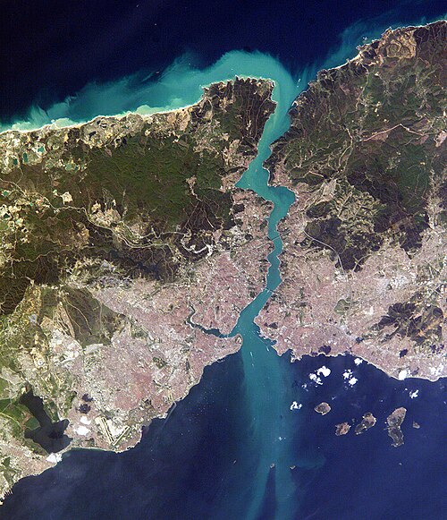
Satellite image of the Bosphorus, taken from the International Space Station in April 2004. The body of water at the top is the Black Sea, the one at the bottom is the Sea of Marmara, and the Bosphorus is the winding vertical waterway that connects the two. The western banks of the Bosphorus constitute the geographic starting point of the European continent, while the banks to the east are the geographic beginnings of the continent of Asia. The city of

The 1915 Çanakkale Bridge on the Dardanelles strait, connecting Europe and Asia, is the longest suspension bridge in the world.
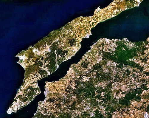
View of the Dardanelles, taken from the Landsat 7 satellite in September 2006. The body of water at the upper left is the Aegean Sea, while the one on the upper right is the Sea of Marmara. The long, narrow upper peninsula is Gallipoli (Turkish: Gelibolu), and constitutes the banks of the continent of Europe, while the lower peninsula is Troad (Turkish: Biga) and constitutes the banks of the continent of Asia. The Dardanelles is the tapered waterway running diagonally between the two peninsulas, from the northeast to the southwest. The city of
Fatih Sultan Mehmet Bridge
Videos
The Fatih Sultan Mehmet Bridge, also known as the Second Bosphorus Bridge, is a bridge in Istanbul, Turkey spanning the Bosphorus Strait. When completed in 1988, it was the 5th-longest suspension brid

Fatih Sultan Mehmet Bridge in Istanbul, connecting Europe and Asia

Fatih Sultan Mehmet Bridge and the skyscrapers of Levent (left) and Maslak (right) business districts