Typhoon Xangsane, known in the Philippines as Typhoon Milenyo, was a typhoon that affected the Philippines, Vietnam, and Thailand during the 2006 Pacific typhoon season. The name Xangsane was submitted by Laos and means elephant.
Xangsane at peak intensity near the Philippines on September 27
TRMM image showing Xangsane's well-defined eyewall prior to its first landfall
Xangsane inland over eastern Indochina
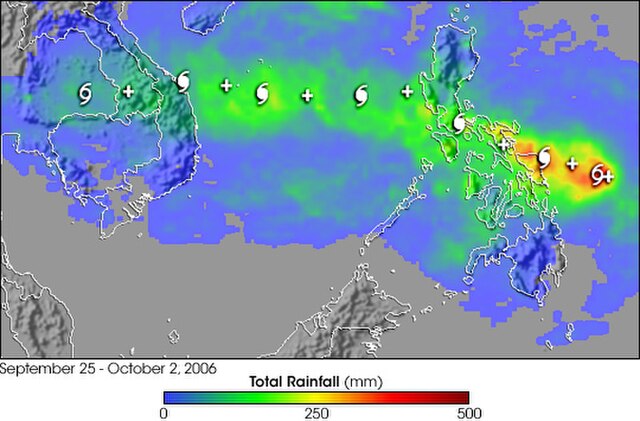
This image shows rainfall totals for Southeast Asia for September 25 – October 2, 2006 estimated in part from data collected by the Tropical Rainfall Measuring Mission satellite. Storm symbols mark out the path of the typhoon. Totals of over a foot are shown over Samar in the east-central Philippines (red areas). A broad area of 4- to 8-inch totals (green) stretches from the central Philippines to the coast of Vietnam.
2006 Pacific typhoon season
The 2006 Pacific typhoon season was a near-average season which produced a total of 23 named storms, 15 typhoons, and six super typhoons. The season ran throughout 2006, though most tropical cyclones typically develop between May and October. The season's first named storm, Chanchu, developed on May 9, while the season's last named storm, Trami, dissipated on December 20.
2006 Pacific typhoon season
2006 Pacific typhoon season
2006 Pacific typhoon season
2006 Pacific typhoon season