Typhoons in the Korean Peninsula
The Korean Peninsula is a peninsula region located over Eastern Asia. The region is divided into North Korea and South Korea.
Typhoon Bavi approaching South Korea as a Category 3 typhoon in August 2020
Tropical Storm Gladys in August 1991; it is the seventh deadliest storm to hit the region
Typhoon Maemi nearing South Korea on September 12, 2003
Typhoon Soulik approaching Korea on August 22, 2018
A typhoon is a tropical cyclone that develops between 180° and 100°E in the Northern Hemisphere and which produces sustained hurricane-force winds of at least 119 km/h (74 mph). This region is referred to as the Northwestern Pacific Basin, accounting for almost one third of the world's tropical cyclones. The term hurricane refers to a tropical cyclone in the north central and northeast Pacific, and the north Atlantic. In all of the preceding regions, weaker tropical cyclones are called tropical storms. For organizational purposes, the northern Pacific Ocean is divided into three regions: the eastern, central, and western. The Regional Specialized Meteorological Center (RSMC) for tropical cyclone forecasts is in Japan, with other tropical cyclone warning centres for the northwest Pacific in Hawaii, the Philippines, and Hong Kong. Although the RSMC names each system, the main name list itself is coordinated among 18 countries that have territories threatened by typhoons each year.

Satellite image of Typhoon Mangkhut
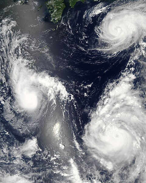
Three different tropical cyclones active over the Western Pacific Ocean on August 7, 2006 (Maria, Bopha, and Saomai). The cyclones on the lower and upper right are typhoons.
Tracks of all tropical cyclones in the northernwestern Pacific Ocean between 1980 and 2005. The vertical line to the right is the International Date Line.