Quebec Route 138
Route 138 is a major highway in the Canadian province of Quebec, following the entire north shore of the Saint Lawrence River past Montreal to the temporary eastern terminus in Kegashka on the Gulf of Saint Lawrence. The western terminus is at the border with New York State south-west of Montreal. Part of this highway is known as the Chemin du Roy, or King's Highway, one of the oldest highways in Canada, it passes through the Montérégie, Lanaudière, Capitale-Nationale and Côte-Nord regions of Quebec. In Montreal, Highway 138 runs via Sherbrooke Street, crosses the Pierre Le Gardeur Bridge to Charlemagne and remains a four-lane road until exiting Repentigny; this highway takes a more scenic route than the more direct Autoroute 40 between Montreal and Quebec City. It crosses the Saguenay River via a ferry which travels between Tadoussac; until the mid-1990s, the highway's eastern terminus was Havre-Saint-Pierre, but in 1996 the extension to Natashquan was completed. A 40 km section between Natashquan and Kegashka opened on September 26, 2013, with the inauguration of a bridge across the Natashquan River.
A second segment of about 17 km extends from Tête-à-la-Baleine's airport, east through Tête-à-la-Baleine, Quebec, to the ferry terminal southeast of Tête-à-la-Baleine. There is a 10.7 km roadway, la route Mecatina, from Mutton Bay to a ferry terminal in La Tabatière and continuing beyond. A third segment of Route 138 extends from Old Fort to the Newfoundland and Labrador border, near Blanc-Sablon on the eastern end of the Côte-Nord. A gap remains between Kegashka and Old Fort, through isolated communities accessible only by coastal ferry. On August 25, 2006, the Quebec government announced a 10-year project to connect the two segments by building 425 km of highway along the Lower North Shore. In 2011, the Quebec government announced an additional $122 million investment for the project over five years as part of the Plan Nord. However, by 2013 difficulties ensued between the Quebec Ministry of Transport and the Pakatan Corporation, responsible for managing the funding for this project, leading to the termination of agreement between the two.
By this time only 12 km of this road had been built, plus some additional engineering work and deforestation. The construction of two segments of the highway is set to begin in 2019. A total of $232 million will be contributed to this project. Quebec Route 2 and Chemin du Roy List of Quebec provincial highways Provincial Route Map Overview Google map for QC 138 from Montreal border to Natashquan Overview Google map for QC 138 from Montreal to New York border Overview Google map for QC 138 from dead end to Newfoundland and Labrador border
Montreal
Montreal is the most populous municipality in the Canadian province of Quebec and the second-most populous municipality in Canada. Called Ville-Marie, or "City of Mary", it is named after Mount Royal, the triple-peaked hill in the heart of the city; the city is centred on the Island of Montreal, which took its name from the same source as the city, a few much smaller peripheral islands, the largest of, Île Bizard. It has a distinct four-season continental climate with cold, snowy winters. In 2016, the city had a population of 1,704,694, with a population of 1,942,044 in the urban agglomeration, including all of the other municipalities on the Island of Montreal; the broader metropolitan area had a population of 4,098,927. French is the city's official language and is the language spoken at home by 49.8% of the population of the city, followed by English at 22.8% and 18.3% other languages. In the larger Montreal Census Metropolitan Area, 65.8% of the population speaks French at home, compared to 15.3% who speak English.
The agglomeration Montreal is one of the most bilingual cities in Quebec and Canada, with over 59% of the population able to speak both English and French. Montreal is the second-largest French-speaking city in the world, after Paris, it is situated 258 kilometres south-west of Quebec City. The commercial capital of Canada, Montreal was surpassed in population and in economic strength by Toronto in the 1970s, it remains an important centre of commerce, transport, pharmaceuticals, design, art, tourism, fashion, gaming and world affairs. Montreal has the second-highest number of consulates in North America, serves as the location of the headquarters of the International Civil Aviation Organization, was named a UNESCO City of Design in 2006. In 2017, Montreal was ranked the 12th most liveable city in the world by the Economist Intelligence Unit in its annual Global Liveability Ranking, the best city in the world to be a university student in the QS World University Rankings. Montreal has hosted multiple international conferences and events, including the 1967 International and Universal Exposition and the 1976 Summer Olympics.
It is the only Canadian city to have held the Summer Olympics. In 2018, Montreal was ranked as an Alpha− world city; as of 2016 the city hosts the Canadian Grand Prix of Formula One, the Montreal International Jazz Festival and the Just for Laughs festival. In the Mohawk language, the island is called Tiohtià:ke Tsi, it is a name referring to the Lachine Rapids to the island's Ka-wé-no-te. It means "a place where nations and rivers unite and divide". In the Ojibwe language, the land is called Mooniyaang which means "the first stopping place" and is part of the seven fires prophecy; the city was first named Ville Marie by European settlers from La Flèche, or "City of Mary", named for the Virgin Mary. Its current name comes from the triple-peaked hill in the heart of the city. According to one theory, the name derives from mont Réal,. A possibility by the Government of Canada on its web site concerning Canadian place names, is that the name was adopted as it is written nowadays because an early map of 1556 used the Italian name of the mountain, Monte Real.
Archaeological evidence demonstrates that First Nations native people occupied the island of Montreal as early as 4,000 years ago. By the year AD 1000, they had started to cultivate maize. Within a few hundred years, they had built fortified villages; the Saint Lawrence Iroquoians, an ethnically and culturally distinct group from the Iroquois nations of the Haudenosaunee based in present-day New York, established the village of Hochelaga at the foot of Mount Royal two centuries before the French arrived. Archeologists have found evidence of their habitation there and at other locations in the valley since at least the 14th century; the French explorer Jacques Cartier visited Hochelaga on October 2, 1535, estimated the population of the native people at Hochelaga to be "over a thousand people". Evidence of earlier occupation of the island, such as those uncovered in 1642 during the construction of Fort Ville-Marie, have been removed. Seventy years the French explorer Samuel de Champlain reported that the St Lawrence Iroquoians and their settlements had disappeared altogether from the St Lawrence valley.
This is believed to be due to epidemics of European diseases, or intertribal wars. In 1611 Champlain established a fur trading post on the Island of Montreal, on a site named La Place Royale. At the confluence of Petite Riviere and St. Lawrence River, it is where present-day Pointe-à-Callière stands. On his 1616 map, Samuel de Champlain named the island Lille de Villemenon, in honour of the sieur de Villemenon, a French dignitary, seeking the viceroyship of New France. In 1639 Jérôme Le Royer de La Dauversière obtained the Seigneurial title to the Island of Montreal in the name of the Notre Dame Society of Montreal to establish a Roman Catholic mission to evangelize natives. Dauversiere hired Paul Chomedey de Maisonneuve 30, to lead a group of colonists to build a mission on his new seigneury; the colonists left France in 1641 for Quebec, arrived on the island the following year. On May 17, 1642, Ville-Marie was founded on the southern shore of Montreal is
Area codes 514 and 438
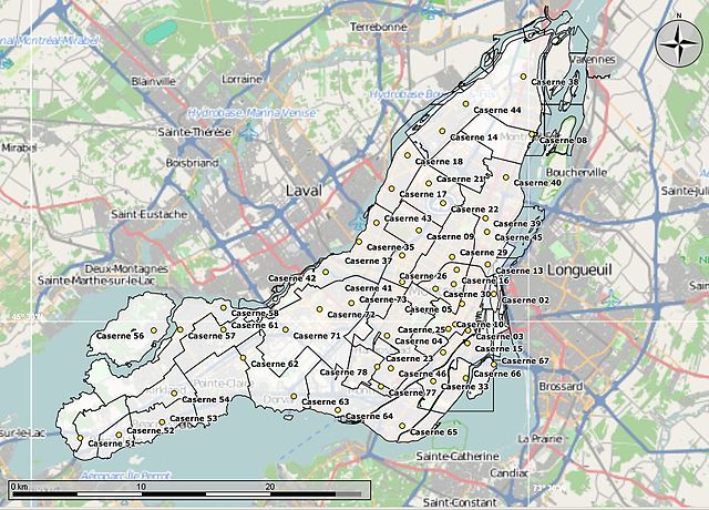
Area codes 514 and 438 are the telephone area codes for Montreal and most of its on-island suburbs. They cover the Island of Montreal, Île Perrot, Île Bizard in the province of Quebec; the main area code, 514, was one of the 86 original North American Numbering Plan Areas defined in 1947. 438 is an overlay area code covering the same area. The 514 area code has been split twice; the incumbent local exchange carrier for 514/438 is Bell Canada. The competitive local exchange carriers for 514/438 are Vidéotron, Telus and some independent companies. Montreal's local calls were handled manually by operators. In 1898, exchange names were added before the number; the initial rotary dial exchange, "Lancaster", was deployed April 25, 1925. Subscribers dialled two letters of an exchange name and four digits, so "Lancaster 1234" became LA-1234; the initial area codes were created in 1947 as routing codes for operator-assisted calls. Québec and Ontario were the only provinces. Quebec was split between area codes 514 and 418.
514 covered the entire western half of Quebec, from the Canada–US border to the Hudson Strait. This area nominally included several remote areas in the far northern portion of the province which, at the time, didn't have telephone service; the first Bell System direct distance dial call was made in 1951, from Englewood, New Jersey to Alameda, using a system based on fixed-length area codes plus seven-digit local numbers. Montreal and Toronto, the largest Canadian cities, were six digits at the time. Between 1951 and 1958, numbers were lengthened by adding a digit in preparation for deployment of direct distance dialling; the 514 area code was split in 1957 to create area code 819 for most of western Quebec, from Estrie to the Ontario border, with the then-unserved far northern portion nominally added to 418. 514 was reduced to the region surrounding Montreal. Despite Montreal's rapid growth in the second half of the 20th century, this configuration remained unchanged for 41 years. In 1998, the off-island suburbs became area code 450, which now surrounds 514.
This left 514 as the Island of a few surrounding smaller islands. The 1998 split was intended as a long-term solution to a shortage of available numbers in Canada's second-largest toll-free calling zone. However, within less than a decade 514 was close to exhaustion once again due to Montreal's rapid growth and Canada's inefficient system of number allocation. Unlike the United States, Canada does not use number pooling as a relief measure; every competing carrier is given access to blocks of 10,000 numbers—corresponding to a single prefix—in every rate centre, no matter how small. This resulted in thousands of wasted numbers, a problem exacerbated by the proliferation of cell phones. While smaller rate centres don't need that many numbers, a number can't be allocated elsewhere once assigned to a CLEC and rate centre. Many larger cities are split between multiple rate centres. Montreal is an exception; the number allocation problem is not as severe in Montreal as in other areas of Canada, since numbers tend to be used up quickly.
However, it was obvious. By this time, overlay area codes had become the preferred relief measure in Canada, as they are an easy workaround for the number allocation problem; the 514 area was overlaid with area code 438 on November 4, 2006, making ten-digit dialing mandatory in the Montreal area. Although the number allocation problem has never been addressed, under current projections Montreal will not need another area code until 2025. Despite Montreal's continued growth, 514/438 is nowhere near exhaustion. Area code 438 was considered for overlaying 450 as well, but a decision determined that 579 would be the overlay code for that area. Montreal — most of / except as listed belowA few western on-island suburbs were never combined into the main Montreal rate centre and therefore have a reduced subset of the Montreal local calling area. In some cases, the corresponding municipality disappeared in the 2002 forced amalgamation but the restricted local calling area remains; these arbitrary boundaries do not correspond in any way to the original boroughs, the "une île, une ville" municipal amalgamation or the subsequent de-fusion of areas like Westmount.
Île-Perrot — 320, 425, 446, 453, 477, 478, 536, 539, 612, 646, 681, 901, 902, 257, 638, 700, 890 Lachine — 300, 307, 403, 420, 422, 469, 471, 492, 532, 538, 552, 556, 600, 631, 633, 634, 635, 636, 637, 639, 689, 780, 828, 264, 600, 819, 891 Pointe-Claire — 319, 426, 427, 428, 429, 457, 459, 500, 505, 534, 541, 558, 630, 671, 674, 693, 694, 695, 697, 698, 782, 783, 900, 265, 500, 538, 893 Roxboro — 309, 421, 472, 491, 533, 542, 545, 613, 615, 628, 676, 683, 684, 685, 752, 763, 894 Sainte-Geneviève — 305, 308, 479, 535, 547, 551, 565, 620, 624, 626, 675, 682, 696, 700, 784, 785, 818, 895Due to Canada's number allocation system, when a CLEC reserves one prefix for each of the island's six rate centres, it has the effect of reserving 60,000 numbers before enrolling its first subscriber. CNA exchange list for area +1-438 CNA exchange list for area +1-514 Official planning letter on NANPA's website. Area Code Map of Canada
Valérie Plante
Valérie Plante is a Canadian politician serving as the 45th and current Mayor of Montreal since 2017. First elected to Montreal City Council in the 2013 election, she has served as leader of the Projet Montréal party since December 2016, she was Projet Montréal's candidate for mayor in the 2017 municipal election, was elected Mayor of Montreal on November 5, 2017. She is the first woman to be elected mayor of Montreal, having been preceded only by councillor Jane Cowell-Poitras's two brief stints as acting mayor following mayoral resignations in the early 2010s and by the ceremonial appointment of Lise Payette as mayor of the city for one day to mark the International Women's Year in 1976. Plante was born in Rouyn-Noranda, Quebec on June 14, 1974, she spent a year in Ontario as a teenager to learn English. In 1994 she moved to Montreal to attend university, receiving a degree in anthropology in 1997, another in museology in 2001, she worked for a number of non-profit organizations, most notably as communications director of the Girls Action Foundation - Fondation Filles d'Action.
In the 1990s she worked as a tour guide at Vimy Ridge in France. In the Montreal municipal election, 2013, Plante was elected councillor for the Sainte-Marie district of the Ville-Marie borough, defeating former provincial minister and 2009 Montreal mayoral candidate Louise Harel, she was named opposition critic for downtown and for women's affairs. She was named vice-president of city council, as well as substitute mayor for Ville-Marie. In the fall of 2016, Plante announced her run for the leadership of Projet Montréal, she went on defeating Guillaume Lavoie. Valérie Plante was elected Mayor of Montreal on November 5, 2017, becoming the first woman to be elected in this position. Few had predicted that Plante would be able to take down the incumbent mayor, Denis Coderre, a former Liberal MP and cabinet minister, at the beginning of the campaign. Plante won over voters on a promise to improve public transit, alleviate traffic woes and make the city more family friendly. On election day, Plante won 51 percent of the vote, compared to 46 percent for Coderre.
Projet Montréal won a majority of seats on the city council. One of Plante's key campaign planks in the 2017 municipal election was the creation of a "Pink Line", a new Montreal Metro line to improve public transit service between downtown and on two axes to the boroughs of Montréal-Nord and Lachine. Plante has two children, she is married to an economist with the Centrale des syndicats du Québec. Valérie Plante, Mayor of Montréal
McGill College Avenue
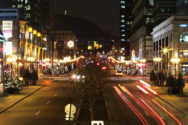
McGill College Avenue is a street in downtown Montreal, Canada. Named for McGill University, the street was widened in the 1980s and transformed into a scenic avenue with McGill's Roddick Gates on Sherbrooke Street at its north end and the Place Ville Marie plaza at its south end; the street was first laid out in 1857, on the axis leading up to the original McGill College Building, now the Arts Building of McGill University. Proposals to widen McGill College date back to at least 1952, when the French architect Jacques Greber submitted a design to the City of Montreal. In 1983, the plan to widen McGill College as a scenic avenue was imperiled by a proposal to house a concert hall in Place Montreal Trust, with a design for an office tower that would have obstructed the view of Mount Royal; the plan encountered public opposition, including from architectural activist Phyllis Lambert, a member of the board of directors of Cadillac Fairview, the project's developer. This idea of a concert hall on McGill College was abandoned in favour of a design for Place Montreal Trust with a wider setback.
Montreal's concert hall would instead be built further east, as part of the Place des Arts complex. Only four blocks in length, buildings along McGill College include 1981 McGill College 1253 McGill College, 1501 McGill College, Place Montreal Trust and its adjoining Bell Media Tower, Centre Eaton. Public art on the street includes the sculpture The Illuminated Crowd by Raymond Mason, in front of 1981 McGill College. During the summer, the west sidewalk is the site of photography exhibitions by the nearby McCord Museum. Since 2001, the street has been the site of the Montréal Fashion and Design Festival, which takes place each year in early August. Christopher DeWolf. "The Evolution of McGill College Avenue". URBANPHOTO. Retrieved 2008-03-28. Montréal Fashion and Design Festival website
Alexandre Leduc
Alexandre Leduc is a Canadian politician, elected to the National Assembly of Quebec in the 2018 provincial election. He represents the electoral district of Hochelaga-Maisonneuve as a member of Québec solidaire
Quebec
Quebec is one of the thirteen provinces and territories of Canada. It is bordered to the west by the province of Ontario and the bodies of water James Bay and Hudson Bay. S. states of Maine, New Hampshire and New York. It shares maritime borders with Nunavut, Prince Edward Island, Nova Scotia. Quebec is Canada's largest province by its second-largest administrative division, it is and politically considered to be part of Central Canada. Quebec is the second-most populous province of Canada, after Ontario, it is the only one to have a predominantly French-speaking population, with French as the sole provincial official language. Most inhabitants live in urban areas near the Saint Lawrence River between Montreal and Quebec City, the capital. Half of Quebec residents live in the Greater Montreal Area, including the Island of Montreal. English-speaking communities and English-language institutions are concentrated in the west of the island of Montreal but are significantly present in the Outaouais, Eastern Townships, Gaspé regions.
The Nord-du-Québec region, occupying the northern half of the province, is sparsely populated and inhabited by Aboriginal peoples. The climate around the major cities is four-seasons continental with cold and snowy winters combined with warm to hot humid summers, but farther north long winter seasons dominate and as a result the northern areas of the province are marked by tundra conditions. In central Quebec, at comparatively southerly latitudes, winters are severe in inland areas. Quebec independence debates have played a large role in the politics of the province. Parti Québécois governments held referendums on sovereignty in 1980 and 1995. Although neither passed, the 1995 referendum saw the highest voter turnout in Quebec history, at over 93%, only failed by less than 1%. In 2006, the House of Commons of Canada passed a symbolic motion recognizing the "Québécois as a nation within a united Canada". While the province's substantial natural resources have long been the mainstay of its economy, sectors of the knowledge economy such as aerospace and communication technologies and the pharmaceutical industry play leading roles.
These many industries have all contributed to helping Quebec become an economically influential province within Canada, second only to Ontario in economic output. The name "Québec", which comes from the Algonquin word kébec meaning "where the river narrows" referred to the area around Quebec City where the Saint Lawrence River narrows to a cliff-lined gap. Early variations in the spelling of the name included Kébec. French explorer Samuel de Champlain chose the name Québec in 1608 for the colonial outpost he would use as the administrative seat for the French colony of New France; the province is sometimes referred to as "La belle province". The Province of Quebec was founded in the Royal Proclamation of 1763 after the Treaty of Paris formally transferred the French colony of Canada to Britain after the Seven Years' War; the proclamation restricted the province to an area along the banks of the Saint Lawrence River. The Quebec Act of 1774 expanded the territory of the province to include the Great Lakes and the Ohio River Valley and south of Rupert's Land, more or less restoring the borders existing under French rule before the Conquest of 1760.
The Treaty of Paris ceded territories south of the Great Lakes to the United States. After the Constitutional Act of 1791, the territory was divided between Lower Canada and Upper Canada, with each being granted an elected legislative assembly. In 1840, these become Canada East and Canada West after the British Parliament unified Upper and Lower Canada into the Province of Canada; this territory was redivided into the Provinces of Quebec and Ontario at Confederation in 1867. Each became one of the first four provinces. In 1870, Canada purchased Rupert's Land from the Hudson's Bay Company and over the next few decades the Parliament of Canada transferred to Quebec portions of this territory that would more than triple the size of the province. In 1898, the Canadian Parliament passed the first Quebec Boundary Extension Act that expanded the provincial boundaries northward to include the lands of the local aboriginal peoples; this was followed by the addition of the District of Ungava through the Quebec Boundaries Extension Act of 1912 that added the northernmost lands of the Inuit to create the modern Province of Quebec.
In 1927, the border between Quebec and Newfoundland and Labrador was established by the British Judicial Committee of the Privy Council. Quebec disputes this boundary. Located in the eastern part of Canada, part of Central Canada, Quebec occupies a territory nearly three times the size of France or Texas, most of, sparsely populated, its topography is different from one region to another due to the varying composition of the ground, the climate, the proximity to water. The Saint Lawrence Lowland and the Appalachians are the two main topographic regions in southern Quebec, while the Canadian Shield occupies most of central and northern Quebec. Quebec has one of the world's largest reserves of fresh water, occupying 12% of its surface, it has 3 % of the world's renewable fresh water. Mor