Wheeling Island
Videos
Wheeling Island is the most populated island in the Ohio River. It lies within the city of Wheeling in Ohio County, West Virginia, in the United States. The 2000 census showed a resident population of 3,142 people on the island, which has a land area of 1.514 square kilometres. Neville Island, Pennsylvania, is larger but has fewer people (1,232).

Buildings on Wheeling Island as viewed across the east channel of the Ohio River from downtown Wheeling in 2006. The hills in the background are in Belmont County, Ohio.
Wheeling Suspension Bridge
Videos
The Wheeling Suspension Bridge is a suspension bridge spanning the main channel of the Ohio River at Wheeling, West Virginia. It was the largest suspension bridge in the world from 1849 until 1851. Charles Ellet Jr. designed it and supervised construction of what became the first bridge to span a major river west of the Appalachian mountains. It linked the eastern and western section of the National Road, and became especially strategically important during the American Civil War. Litigation in the United States Supreme Court concerning its obstruction of the new high steamboat smokestacks eventually cleared the way for other bridges, especially needed by expanding railroads. Because this bridge was designed during the horse-and-buggy era, 2-ton weight limits and vehicle separation requirements applied in later years until it was closed to automobile traffic in September 2019.

View from the Wheeling Suspension Bridge, 1977. Photo taken from City of Wheeling side, looking west toward Wheeling Island.
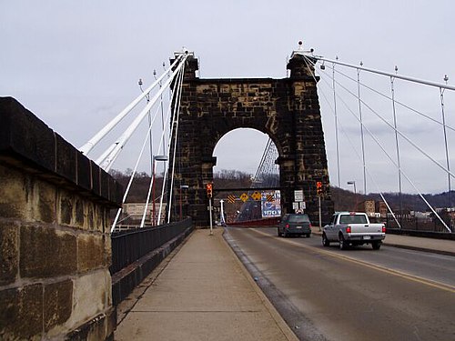
Photo taken from Wheeling Island side, looking east toward the City of Wheeling

Frontispiece to the Wheeling & Belmont Bridge Company's printed argument delivered to the U.S. Supreme Court in the case Pennsylvania v. Wheeling and Belmont Bridge Company, 54 U.S. 518 (1850)

Flood of 1852 – earliest known photograph of the Wheeling Suspension Bridge