1.
Somerset
–
Somerset is a county in South West England which borders Gloucestershire and Bristol to the north, Wiltshire to the east, Dorset to the south-east and Devon to the south-west. It is bounded to the north and west by the Severn Estuary and its traditional border with Gloucestershire is the River Avon. Somerset is a county of rolling hills such as the Blackdown Hills, Mendip Hills, Quantock Hills and Exmoor National Park. There is evidence of occupation from Paleolithic times, and of subsequent settlement in the Roman. The county played a significant part in the consolidation of power and rise of King Alfred the Great, and later in the English Civil War, the city of Bath is famous for its substantial Georgian architecture and is a UNESCO World Heritage Site. Somersets name derives from Old English Sumorsǣte, short for Sumortūnsǣte, an alternative suggestion is the name derives from Seo-mere-saetan meaning settlers by the sea lakes. The Old English name is used in the motto of the county, Sumorsǣte ealle, adopted as the motto in 1911, the phrase is taken from the Anglo-Saxon Chronicle. Somerset settlement names are mostly Anglo-Saxon in origin, but some hill names include Brittonic Celtic elements, for example, an Anglo-Saxon charter of 682 refers to Creechborough Hill as the hill the British call Cructan and we call Crychbeorh. Some modern names are Brythonic in origin, such as Tarnock, the caves of the Mendip Hills were settled during the Palaeolithic period, and contain extensive archaeological sites such as those at Cheddar Gorge. Bones from Goughs Cave have been dated to 12,000 BC, examples of cave art have been found in Avelines Hole. Some caves continued to be occupied until modern times, including Wookey Hole, the Somerset Levels—specifically dry points at Glastonbury and Brent Knoll— also have a long history of settlement, and are known to have been settled by Mesolithic hunters. Travel in the area was facilitated by the construction of one of the worlds oldest known engineered roadways, the Sweet Track, the exact age of the henge monument at Stanton Drew stone circles is unknown, but it is believed to be Neolithic. There are numerous Iron Age hill forts, some of which, like Cadbury Castle, on the authority of the future emperor Vespasian, as part of the ongoing expansion of the Roman presence in Britain, the Second Legion Augusta invaded Somerset from the south-east in AD47. The county remained part of the Roman Empire until around AD409, a variety of Roman remains have been found, including Pagans Hill Roman temple in Chew Stoke, Low Ham Roman Villa and the Roman Baths that gave their name to the city of Bath. After the Romans left, Britain was invaded by Anglo-Saxon peoples, by AD600 they had established control over much of what is now England, but Somerset was still in native British hands. The Saxon royal palace in Cheddar was used several times in the 10th century to host the Witenagemot. After the Norman Conquest, the county was divided into 700 fiefs, Somerset contains HM Prison Shepton Mallet, which was Englands oldest prison still in use prior to its closure in 2013, having opened in 1610. In the English Civil War Somerset was largely Parliamentarian, with key engagements being the Sieges of Taunton, in 1685 the Monmouth Rebellion was played out in Somerset and neighbouring Dorset
2.
West Somerset
–
West Somerset is a local government district in the English county of Somerset. The council covers a rural area, with a population of 35,075 in an area of 740 square kilometres. According to figures released by the Office for National Statistics in 2009, the largest centres of population are the coastal towns of Minehead and Watchet. The councils administrative headquarters is located in the village of Williton, in September 2016, West Somerset and Taunton Deane councils agreed in principle to merge the districts into one subject to consultation. It is planned to achieve this on 1 April 2019 with the first elections to the new council in May 2019, the new district would not be a unitary authority, with Somerset County Council still performing its functions. Dunster has the greatest concentration of Grade I listed buildings including Dunster Castle, other sites include manor houses such as Nettlecombe Court and Orchard Wyndham. The most recent buildings included in the list are Crowcombe Court which was completed in 1739, there are numerous religious structures in Somerset, with the largest number being Anglican parish churches, dating from Norman or medieval eras. Some of the churches are included in the Somerset towers, a collection of distinctive and it is proposed that some services may be shared with Taunton Deane council. In December 2012 the grant received from government was increased by 0. 9% meaning the council had £3. 8million to spend on the provision of services. West Somerset benefits from one of the most scenic landscapes in England, large areas of Exmoor and the Quantock Hills are also designated as Sites of Special Scientific Interest because of their value for wildlife. The West Somerset Railway runs through most of the district, from Bishops Lydeard in the south east, operated mainly as a tourist attraction, the railway runs mostly steam and some diesel locomotives. West Somerset District Council is elected every four years, with currently 28 councillors being elected at each election, from the first election to the council in 1973 to the 1995 election the council had a majority of independents. Since then the Conservative Party won a majority at the 2003 election, for a full list of schools see, List of schools in Somerset List of Grade I listed buildings in West Somerset Quay West Radio West Somerset District Council
3.
England
–
England is a country that is part of the United Kingdom. It shares land borders with Scotland to the north and Wales to the west, the Irish Sea lies northwest of England and the Celtic Sea lies to the southwest. England is separated from continental Europe by the North Sea to the east, the country covers five-eighths of the island of Great Britain in its centre and south, and includes over 100 smaller islands such as the Isles of Scilly, and the Isle of Wight. England became a state in the 10th century, and since the Age of Discovery. The Industrial Revolution began in 18th-century England, transforming its society into the worlds first industrialised nation, Englands terrain mostly comprises low hills and plains, especially in central and southern England. However, there are uplands in the north and in the southwest, the capital is London, which is the largest metropolitan area in both the United Kingdom and the European Union. In 1801, Great Britain was united with the Kingdom of Ireland through another Act of Union to become the United Kingdom of Great Britain and Ireland. In 1922 the Irish Free State seceded from the United Kingdom, leading to the latter being renamed the United Kingdom of Great Britain, the name England is derived from the Old English name Englaland, which means land of the Angles. The Angles were one of the Germanic tribes that settled in Great Britain during the Early Middle Ages, the Angles came from the Angeln peninsula in the Bay of Kiel area of the Baltic Sea. The earliest recorded use of the term, as Engla londe, is in the ninth century translation into Old English of Bedes Ecclesiastical History of the English People. According to the Oxford English Dictionary, its spelling was first used in 1538. The earliest attested reference to the Angles occurs in the 1st-century work by Tacitus, Germania, the etymology of the tribal name itself is disputed by scholars, it has been suggested that it derives from the shape of the Angeln peninsula, an angular shape. An alternative name for England is Albion, the name Albion originally referred to the entire island of Great Britain. The nominally earliest record of the name appears in the Aristotelian Corpus, specifically the 4th century BC De Mundo, in it are two very large islands called Britannia, these are Albion and Ierne. But modern scholarly consensus ascribes De Mundo not to Aristotle but to Pseudo-Aristotle, the word Albion or insula Albionum has two possible origins. Albion is now applied to England in a poetic capacity. Another romantic name for England is Loegria, related to the Welsh word for England, Lloegr, the earliest known evidence of human presence in the area now known as England was that of Homo antecessor, dating to approximately 780,000 years ago. The oldest proto-human bones discovered in England date from 500,000 years ago, Modern humans are known to have inhabited the area during the Upper Paleolithic period, though permanent settlements were only established within the last 6,000 years
4.
United Kingdom
–
The United Kingdom of Great Britain and Northern Ireland, commonly known as the United Kingdom or Britain, is a sovereign country in western Europe. Lying off the north-western coast of the European mainland, the United Kingdom includes the island of Great Britain, Northern Ireland is the only part of the United Kingdom that shares a land border with another sovereign state—the Republic of Ireland. The Irish Sea lies between Great Britain and Ireland, with an area of 242,500 square kilometres, the United Kingdom is the 78th-largest sovereign state in the world and the 11th-largest in Europe. It is also the 21st-most populous country, with an estimated 65.1 million inhabitants, together, this makes it the fourth-most densely populated country in the European Union. The United Kingdom is a monarchy with a parliamentary system of governance. The monarch is Queen Elizabeth II, who has reigned since 6 February 1952, other major urban areas in the United Kingdom include the regions of Birmingham, Leeds, Glasgow, Liverpool and Manchester. The United Kingdom consists of four countries—England, Scotland, Wales, the last three have devolved administrations, each with varying powers, based in their capitals, Edinburgh, Cardiff and Belfast, respectively. The relationships among the countries of the UK have changed over time, Wales was annexed by the Kingdom of England under the Laws in Wales Acts 1535 and 1542. A treaty between England and Scotland resulted in 1707 in a unified Kingdom of Great Britain, which merged in 1801 with the Kingdom of Ireland to form the United Kingdom of Great Britain and Ireland. Five-sixths of Ireland seceded from the UK in 1922, leaving the present formulation of the United Kingdom of Great Britain, there are fourteen British Overseas Territories. These are the remnants of the British Empire which, at its height in the 1920s, British influence can be observed in the language, culture and legal systems of many of its former colonies. The United Kingdom is a country and has the worlds fifth-largest economy by nominal GDP. The UK is considered to have an economy and is categorised as very high in the Human Development Index. It was the worlds first industrialised country and the worlds foremost power during the 19th, the UK remains a great power with considerable economic, cultural, military, scientific and political influence internationally. It is a nuclear weapons state and its military expenditure ranks fourth or fifth in the world. The UK has been a permanent member of the United Nations Security Council since its first session in 1946 and it has been a leading member state of the EU and its predecessor, the European Economic Community, since 1973. However, on 23 June 2016, a referendum on the UKs membership of the EU resulted in a decision to leave. The Acts of Union 1800 united the Kingdom of Great Britain, Scotland, Wales and Northern Ireland have devolved self-government
5.
Avon and Somerset Constabulary
–
The first police force in England was formed in Covent Garden by Somerset born novelist Henry Fielding, in 1748. In 1835, Bristol and Bath became the first to create their own forces in the county itself. The original Bristol constabulary had 232 officers issued with a top hat, blue coat and this constabulary began certain practices that were eventually adopted country-wide, including recruiting female officers and photographing prisoners. Bridgwater and Chard followed with their own constabularies in 1839, with all forces being merged into the Somerset Constabulary in 1940 and it was the only force to provide a mounted escort for the Queen during her Royal Jubilee tour of Bristol in 1977. Avon & Somerset Constabulary provides service for approximately 1.5 million people, in January 2013, Port took the PCC to court to seek an injunction to block the interviews of candidates for the post of Chief Constable. In mid-May 2014, Gargan was suspended by Commissioner Mountstevens following allegations of inappropriate behaviour towards female officers, the enquiry into the allegations was referred to the Independent Police Complaints Commission. Gargan is reported by the Commissioner to have denied the allegations, during the period of Gargans suspension, the force was run by the Deputy Chief Constable, John Long. Records of the Bristol Constabulary and Avon and Somerset Constabulary are held at Bristol Archives, the constabulary is overseen by the Avon and Somerset Police and Crime Commissioner, a new elected position which replaced the Avon and Somerset Police Authority in November 2012. The police and crime commissioner is scrutinised by the Avon and Somerset Police and Crime Panel, the first police and crime commissioner, who was elected on 15 November 2012 and took office on 21 November 2012, is Sue Mountstevens. She had previously been a magistrate and a member of the police authority, the Portishead complex cost £31 million to construct and was opened by Queen Elizabeth II on 2 June 1995. Avon and Somerset Police use a total of 41 police stations, targeted Patrol Teams responding to emergency calls. Traffic Units patrol the roads and target and pursue people committing traffic offences, criminal Investigation Departments detect serious crime Forensic Services investigate crime scenes for forensic evidence that may correspond with many of the Home Office databases. Pro-active Policing Units target persistent criminals and focus on specific operations, Dog Units are officers who patrol with dogs and respond to incidents where a police dog is required. The helicopter is staffed by officers of both forces and features various technology including thermal imaging, a spotlight and Global Positioning System. The aircraft has a time of two minutes. The helicopter can also be used as an air ambulance when required and this is now under the control of the NPAS. This collaboration also encompasses the Armed Response Units and Police Dog Patrols, the RPU has 55 cars and 28 motorcycles. The RPU has three bases, Almondsbury, Weston-Super-Mare and Taunton, Avon and Somerset Constabulary has a Support Group that specialise in very specific needs of investigations or missions, such as police divers, football match management and explosive searching
6.
Fire services in the United Kingdom
–
The fire services in the United Kingdom operate under separate legislative and administrative arrangements in England and Wales, Northern Ireland, and Scotland. Emergency cover is provided by over fifty fire and rescue services, many FRS were previously known as brigades or county fire services, but almost all now use the standard terminology. They are distinct from and governed by an authority, which is the legislative, public and administrative body. Fire authorities in England and Wales, and therefore fire and rescue services, Scotland and Northern Ireland have centralised fire and rescue services, and so their authorities are effectively committees of the devolved parliaments. The total budget for services in 2014-15 was £2.9 billion. The devolved government in Scotland has an agency, HMFSI Scotland. This Act provided for centralised co-ordination of fire brigades in Great Britain,1947, Fire Services Act 1947 This Act transferred the functions of the National Fire Service to local authorities. Now repealed entirely in England and Wales by Schedule 2 of the Fire,1959, Fire Services Act 1959 This Act amended the 1947 Act, it dealt with pensions, staffing arrangements and provision of services by other authorities. It was repealed in England and Wales along with the 1947 Act,1999, Greater London Authority Act 1999 This act was necessary to allow for the formation of the Greater London Authority and in turn the London Fire and Emergency Planning Authority. In 2002, there was a series of fire strikes. In December 2002, the Independent Review of the Fire Service was published with the action still ongoing. Bains report ultimately led to a change in the relating to firefighting. 2002, Independent Review of the Fire Service published 2004, Fire and Rescue Services Act 2004, generally only applying to England and it came into force on 1 October 2006. The DfCLG has published a set of guides for non-domestic premises,2006, The Government of Wales Act 2006 gave the National Assembly for Wales powers to pass laws on Fire, promotion of fire safety otherwise than by prohibition or regulation. But does not prevent future legislation being passed by the UK government which applies to two or more constituent countries, There are further plans to modernise the fire service according to the Local Government Association. The fire service in England and Wales is scrutinised by a House of Commons select committee, in June 2006, the fire and rescue service select committee, under the auspices of the Communities and Local Government Committee, published its latest report. For example, where FRSs were historically inspected by HMFSI, much of this work is now carried out by the National Audit Office, Fire Control On 8 February 2010 the House of Commons Communities and Local Government Select Committee heard evidence on the Fire Control project. Called to give evidence were Cllr Brian Coleman and Cllr James Pearson from the Local Government Association, also giving evidence Matt Wrack from the Fire Brigades Union and John Bonney Chief Fire Officers Association
7.
Devon and Somerset Fire and Rescue Service
–
It is the fifth largest fire and rescue service in the United Kingdom. Devon and Somerset Fire and Rescue Service was founded on 1 April 2007, following the merger of Devon Fire and Rescue Service with Somerset Fire, the Somerset service, previously known as Somerset Fire Brigade, was formed on 1 April 1948. Devon Fire Brigade was formed in 1973, by the amalgamation of Exeter City Brigade, Plymouth City Brigade and it became Devon Fire and Rescue Service in 1987. It is organised operationally into three commands, Central, Western and Somerset, the services main headquarters is located at Clyst St George near Exeter. Its main training centre is the Service Training Centre at Plympton fire station, the service employs approximately 1,983 staff, including 624 whole time firefighters and 46 control room staff,1,032 retained firefighters and 281 non-uniformed staff. Each county operated its own room until 2012 but they now have a single control room at Service Headquarters. These are areas that have identified as having a greater need for ambulance cover. The aim of a team is to preserve life until the arrival of either a Rapid Response Vehicle or an ambulance. Co-responder vehicles are equipped with oxygen and automatic external defibrillation equipment, Co-responder stations have a dedicated vehicle for Co-responder calls. The vehicle, known as the response unit, attends in place of the fire appliance. It is the link road to the south west from the Midlands. Devon and Somerset Fire and Rescue Service divide the M5 into sections so that the nearest appliances attend, the dockyard falls into the station ground of 48 Camels Head, and is backed up by 49 Crownhill. Each part of the dockyard is divided into risk areas - this then reflects in the level of attendance by the Fire Service, Hinkley Point is a headland on the coast of Somerset. It is the location of two power stations. Hinkley Point B is the active site. Hinkley Point has its own station, backed up by 67 Nether Stowey. There is a new nuclear power station that will be Hinkley Point C. Devon and Somerset use a variety of front-line and special appliances, operating from 85 fire stations, It has 121 fire engines and 64 special appliances, including aerial appliances, water carriers, incident command units, 4x4s and environmental protection units
8.
Emergency medical services in the United Kingdom
–
Emergency care including ambulance and emergency department treatment is free to everyone, regardless of immigration or visitor status. The NHS commissions most emergency services through the 14 NHS organisations with ambulance responsibility across the UK. As with other services, the public normally access emergency medical services through one of the valid emergency telephone numbers. This led to the formation of predominantly county based ambulance services, which gradually merged up and changed responsibilities until 2006, when there were 31 NHS ambulance trusts in England. Following further changes as part of the NHS foundation trust pathway, the commissioners in each region are responsible for contracting with a suitable organisation to provide ambulance services within their geographical territory. The primary contract for each area is held by a public NHS body, of which there are 11 in England. The service was operated before reorganisation in 1974 by the St Andrews’ Ambulance Association under contract to the Secretary of State for Scotland, the Northern Ireland Ambulance Service was established in 1995 by parliamentary order, and serves the whole of Northern Ireland. The Welsh Ambulance Service NHS Trust was established on 1 April 1998, there is a large market for private and voluntary ambulance services, with the sector being worth £800m to the UK economy in 2012. This places the voluntary providers in direct competition with private services, expenditure on private ambulances in England increased from £37m in 2011−12 to £67. 5m in 2013/4, rising in London from £796,000 to more than £8. 8m. In 2014−15, these 10 ambulance services spent £57.6 million on 333,329 callouts of private or voluntary services - an increase of 156% since 2010−11, in 2013, the CQC found 97% of private ambulance services to be providing good care. These private, registered services are represented by the Independent Ambulance Association, there are also a number of unregistered services operating, who do not provide ambulance transport, but only provide response on an event site. These firms are not regulated, and are not subject to the checks as the registered providers, although they may operate similar vehicles. There are a number of ambulance providers, sometimes known as Voluntary Aid Services or Voluntary Aid Societies, with the main ones being the British Red Cross. The history of the ambulance services pre-dates any government organised service. As they are in competition for work with the private ambulance providers. Voluntary organisations have also provided cover for the public when unionised NHS ambulance trust staff have taken industrial action, there are a number of smaller voluntary ambulance organisations, fulfilling specific purposes, such as Hatzola who provide emergency medical services to the orthodox Jewish community in some cities. These have however run into difficulties due to use of vehicles not legally recognised as ambulances, all emergency medical services in the UK are subject to a range of legal and regulatory requirements, and in many cases are also monitored for performance. This framework is largely statutory in nature, being mandated by government through a range of primary and secondary legislation and this requires all providers to register, to meet certain standards of quality, and to submit to inspection of those standards
9.
A39 road
–
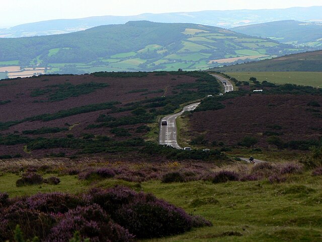
The A39 is an A road in south west England. It runs south-west from Bath in Somerset through Wells, Glastonbury, Street and it then follows the north coast of Somerset, Devon and Cornwall through Williton, Minehead, Porlock, Lynmouth, Barnstaple, Bideford, Stratton, Camelford, Wadebridge and St Columb Major. It then joins the route of the A30 road for around 5 miles, re-emerging near Zelah to head for the south Cornish coast via Truro, in Cornwall and North Devon, the road is known as the Atlantic Highway, and was classified as a trunk road until 2002. Porlock Hill is a section of the A39 west of the village of Porlock, the road climbs approximately 1,300 ft in less than 2 miles up onto Exmoor, a very steep hill with gradients of up to 1 in 4 and hairpin bends. In Porlock itself you will often smell burning brakes from vehicles who have just descended the hill, on 12 January 1899, the ten-ton Lynmouth lifeboat was launched during a storm, but the storms ferocity meant it could not put out to sea. Instead, it was retrieved and hauled by men and twenty horses over Countisbury, the endeavour eventually enabled thirteen seamen to be rescued. There is a less steep toll road that small vehicles and cyclists can take as an alternative route and it formed part of the route in the 2007 Tour of Britain cycle race. Another alternative for cyclists, avoiding tolls, is provided by part of Regional Cycle Route 51, about 9.3 miles to the west of Porlock Hill, the A39 starts its equivalent descent from the hills of Exmoor. Within about 2.5 miles, the road descends the 1,300 ft it had previously climbed, the original road between Lynmouth and Lynton was much more challenging with gradients of around 1 in 3. It is now the B3234, Lynmouth Hill, at Martinhoe Cross in Devon—about 5 miles west of Lynton and 2 miles east of Parracombe—on the north side of the A39 lies a once disused but, in 2004, restored and reopened railway station. Woody Bay was once a stop on, and is now the main operating centre of, the Lynton & Barnstaple Railway a narrow-gauge line built in 1898. Over- and under-bridges and other traces of the line can be seen at locations along this stretch of the road. Atlantic Highway is the given to a section of the A39. It is so called, as it is the road from mid-Cornwall to North Devon. It is also named thus due to the former Southern Railway express that ran in this part of North Devon, views of the Atlantic can be seen along its length, although the road does not approach very close to the coastline itself. It passes by Wadebridge, Bude and Bideford, and directly through Camelford, l&B Railway Project SABRE page on the A39
10.
Watchet
–
Watchet is a harbour town, civil parish and electoral ward in the English county of Somerset, with a population of 3,785. It is situated 15 miles west of Bridgwater,15 miles north-west of Taunton, the parish includes the hamlet of Beggearn Huish. The town lies at the mouth of the Washford River on Bridgwater Bay, part of the Bristol Channel, the original settlement may have been at the Iron Age fort Daws Castle. It then moved to the mouth of the river and a small harbour developed, named by the celts as Gwo Coed meaning Under the Wood. After the Saxon conquest of the area the town developed and was known as Weced or Waeced and was attacked by Vikings in the 10th century, the West Somerset Railway also served the town and port bringing goods and people from the Bristol and Exeter Railway. The iron ore trade reduced and ceased in the early-20th century, the port continued a smaller commercial trade until 2000 when it was converted into a marina. The church is dedicated to Saint Decuman who is thought to have died here around 706, an early church was built near Daws Castle and a new church was erected in the 15th century. It has several tombs and monuments to Sir John Wyndham and his family who were the lords of the manor, samuel Taylor Coleridges poem The Rime of the Ancient Mariner which was written in the area is commemorated by a statue on the harbourside. Daws Castle is an Iron Age sea cliff hill fort about 0.5 miles to the west of the town. It was built and fortified, on the site of a settlement, as a burh by Alfred the Great. It is situated on an east-west cliff about 80 metres above the sea and its ramparts would have formed a semicircle backing on to the sheer cliffs, but only about 300 metres are visible today. A Saxon mint was established here in 1035, probably within the fort, there is no sign of Roman occupation, but the Anglo-Saxons took Watchet from the native Britons around AD680. Under Alfred the Great Watchet became an important port, and coins minted here have found as far away as Copenhagen. The Anglo-Saxon Chronicle records the early port being plundered by Danes led by Earl Ottir, Watchet is believed to be the place where Saint Decuman was killed around 706 and its parish church is dedicated to him. At the time of the Domesday Book Watchet was part of the held by William de Moyon. The parish of Watchet was in the Williton and Freemanners Hundred in the Middle Ages, T With access to wood from the Quantock Hills, records show that paper making was established by 1652. In the 15th century, a mill was established by the Fulford. By 1587 the Wyndham estate had established a fulling and grist mill to the south west, by 1652, the mill had started to produce paper
11.
Minehead
–
Minehead is a coastal town and civil parish in Somerset, England. It lies on the bank of the Bristol Channel,21 miles north-west of the county town of Taunton,12 miles from the border with the county of Devon. The parish of Minehead has a population of approximately 11,981 making it the most populous town in the West Somerset local government district and this figure includes Alcombe and Woodcombe, suburban villages which have been subsumed into Minehead. There is evidence of occupation in the area since the Bronze. There was a port at Minehead by 1380, which grew into a major trading centre during the medieval period. Most trade transferred to larger ports during the 20th century, there was a marked increase in building during the early years of the 20th century, which resulted in the wide main shopping avenue and adjacent roads with Edwardian style architecture. The towns flood defences were improved after a storm in 1990 caused flooding, Minehead is governed by a town council, which was created in 1983 and has been part of the West Somerset local government district since 1974. In addition to the church of St. Michael on the Hill in Minehead. Alcombe is also home to the Spiritualist Church in Grove Place, since 1991, Minehead has been twinned with Saint-Berthevin, a small town close to the regional centre of Laval in the Mayenne département of France. Blenheim Gardens, which is Minehead’s largest park, was opened in 1925, the town is also the home of a Butlins Holiday Park which increases Mineheads seasonal tourist population by several thousand. There are a variety of schools and religious, cultural and sporting facilities including sailing and wind surfing, the town is the starting point of the South West Coast Path National Trail, the nations longest long-distance countryside walking trail. The Minehead Railway was opened in 1874 and closed in 1971 but has since reopened as the West Somerset Railway. The town sits at the foot of a steeply rising outcrop of Exmoor known as North Hill, and the name of the town was mynydd. It has also written as Mynheafdon, Maneheve, Menehewed and Menedun. Minehead was part of the hundred of Carhampton and it is mentioned as a manor belonging to William de Moyon in the Domesday Book in 1086, although it had previously been held by Ælfgar, Earl of Mercia. William de Mohun of Dunster, 1st Earl of Somerset and his descendants administered the area from Dunster Castle, which was later sold to Sir George Luttrell and his family. There was a port at Minehead by 1380, but it was not until 1420 that money given by Lady Margaret Luttrell enabled improvements to be made. During the reign of Elizabeth I, the town had its own Port Officer similar to the position at Bristol, vessels in the 15th century included the Trinite which traded between Ireland and Bristol, and others carrying salt and other cargo from La Rochelle in France
12.
Bridgwater
–
Bridgwater is a market town and civil parish in Somerset, England. At the 2011 census, it had a population of 35,886, Bridgwater is at the edge of the Somerset Levels, in level and well-wooded country, to the north are the Mendips and to the west the Quantock hills. The town lies along both sides of the River Parrett,10 miles from its mouth, has been a port and trading centre. It is linked to Taunton by the Bridgwater and Taunton Canal, Bridgwater is between two junctions of the M5 motorway and Bridgwater railway station is on the main railway line between Bristol and Taunton. Historically, the town had a politically radical tendency, the Battle of Sedgemoor, where the Monmouth Rebellion was finally crushed in 1685, was fought nearby. Notable buildings include the Church of St Mary and the house in Blake Street, largely restored, which was the birthplace of Admiral Blake in 1598, the town has an arts centre and plays host to the annual Bridgwater Guy Fawkes Carnival. It is thought that the town was originally called Brigg, meaning quay and it has been argued that the name may instead come from the Old English brycg or Old Norse bryggja, though this idea has been opposed on etymological grounds. In the Domesday Book the town is listed as Brugie, while Brugia was also used, after the Norman invasion the land was given to Walter of Douai, hence becoming known variously as Burgh-Walter, Brugg-Walter and Brigg-Walter, eventually corrupted to Bridgwater. An alternative version is that it derives from Bridge of Walter and it was formerly part of the Hundred of North Petherton. William Briwere was granted the lordship of the Manor of Bridgwater by John of England in 1201, through Briweres influence, King John granted three charters in 1200, for the construction of Bridgwater Castle, for the creation of a borough, and for a market. Bridgwater Castle was a structure built in Old Red Sandstone. A tidal moat, up to 65 feet wide in places, flowed about along the line of the thoroughfares of Fore Street and Castle Moat. The main entrance opposite the Cornhill was built with a pair of adjacent gates and drawbridges, in addition to a keep, located at the south-east corner of what is now King Square, documents show that the complex included a dungeon, chapel, stables and a bell tower. Built on the raised ground in the town, the castle controlled the crossing of the town bridge. The foundations of the forming the north-east corner of the castle are buried beneath Homecastle House. William Briwere also went on to found the Franciscan Bridgwater Friary in the town, during the 11th century Second Barons War against Henry III, Bridgwater was held by the barons against the King. Bridgwaters peasants under Nicholas Frampton took part in the Peasants Revolt of 1381, sacking Sydenham House, murdering the local tax collectors, Bridgwater was incorporated by charter of Edward IV, confirmed in 1554,1586,1629 and 1684. Parliamentary representation as a borough constituency began in 1295 and continued until the Reform Act of 1870, from 4 July 1870 the town was incorporated within the county constituency of West Somerset