Mississippi in the American Civil War
Videos
Page
Mississippi was the second southern state to declare its secession from the United States, doing so on January 9, 1861. It joined with six other southern states to form the Confederacy on February 4, 1861. Mississippi's location along the lengthy Mississippi River made it strategically important to both the Union and the Confederacy; dozens of battles were fought in the state as armies repeatedly clashed near key towns and transportation nodes.

Memorial "commemorating the service of the 1st and 3rd Mississippi infantry regiments, and all Mississippians of African Descent who participated in the Vicksburg Campaign"
Mississippi
Videos
Page
Mississippi is a state in the Southeastern region of the United States. It borders Tennessee to the north, Alabama to the east, the Gulf of Mexico to the south, Louisiana to the southwest, and Arkansas to the northwest. Mississippi's western boundary is largely defined by the Mississippi River, or its historical course. Mississippi is the 32nd largest by area and 35th-most populous of the 50 U.S. states and has the lowest per-capita income. Jackson is both the state's capital and largest city. Greater Jackson is the state's most populous metropolitan area, with a population of 591,978 in 2020.

Choctaw Village near the Chefuncte, by Francois Bernard, 1869, Peabody Museum—Harvard University. The women are preparing dye in order to color cane strips for making baskets.

Pushmataha, Principal Chief of the Choctaw

D'Evereux Hall in Natchez. Built in 1840, the mansion is listed on the National Register of Historic Places.
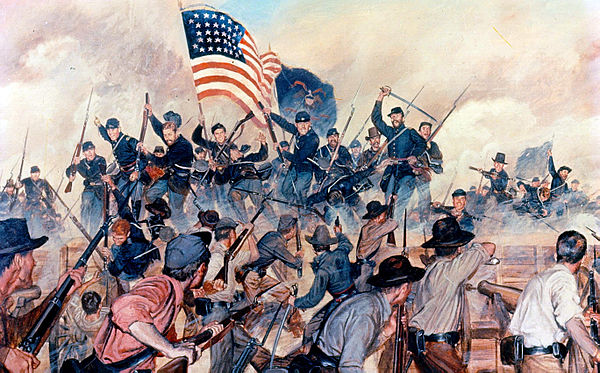
Confederate lines, Vicksburg, May 19, 1863. Shows assault by US 1st Battalion, 13th Infantry.