Azad Kashmir
Videos
Azad Jammu and Kashmir abbreviated as AJK and colloquially referred to as simply Azad Kashmir, is a region administered by Pakistan as a nominally self-governing entity and constituting the western portion of the larger Kashmir region, which has been the subject of a dispute between India and Pakistan since 1947. Azad Kashmir also shares borders with the Pakistani provinces of Punjab and Khyber Pakhtunkhwa to the south and west, respectively. On its eastern side, Azad Kashmir is separated from the Indian union territory of Jammu and Kashmir by the Line of Control (LoC), which serves as the de facto border between the Indian- and Pakistani-controlled parts of Kashmir. Geographically, it covers a total area of 13,297 km2 (5,134 sq mi) and has a total population of 4,045,366 as per the 2017 national census.

Image: Neeulm Valley AJK (Arang Kel)

Image: Shounter Vally 2

Landscape of Azad Kashmir

Paddy field in Leepa valley
Kashmir
Videos
Kashmir is the northernmost geographical region of the Indian subcontinent. Until the mid-19th century, the term "Kashmir" denoted only the Kashmir Valley between the Great Himalayas and the Pir Panjal Range. Today, the term encompasses a larger area that includes the India-administered territories of Jammu and Kashmir and Ladakh, the Pakistan-administered territories of Azad Kashmir and Gilgit-Baltistan, and the Chinese-administered territories of Aksai Chin and the Trans-Karakoram Tract.

Pahalgam Valley, Kashmir

Nanga Parbat in Kashmir, the ninth-highest mountain on Earth, is the western anchor of the Himalayas
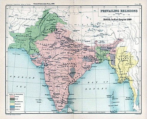
The prevailing religions by district in the 1901 Census of the Indian Empire

A white border painted on a suspended bridge delineates Azad Kashmir from Jammu and Kashmir