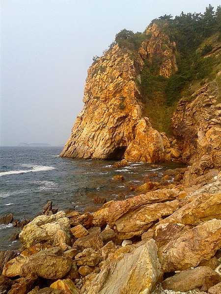
Headlands and bays
Both headland and bay are two coastal features that are related and found on the same coastline. A bay is a body of water—usually seawater and sometimes fresh water— surrounded by land, whereas a headland is surrounded by water on three sides. Headlands are characterized by rocky shores, intense erosion and steep sea cliffs. Bays have less wave activity and have sandy beaches. Headlands and bays form on discordant coastlines, where the land consists of bands of rock of alternating resistance that run perpendicular to the coast. Bays form where less resistant rocks, such as sands and clays, are eroded, leaving bands of stronger, or more resistant rocks, which form a headland or peninsula. Refraction of waves occurs on headlands concentrating wave energy on them, so many other landforms, such as caves, natural arches, stacks, form on headlands. Wave energy is directed at right angles to the wave crest, lines drawn at right angles to the wave crest represent the direction of energy expenditure. Orthogonals converge on headlands and diverge in bays, which concentrates wave energy on the headlands and dissipates wave energy in the bays.
In the formation of sea cliffs, wave erosion undercuts the slopes at the shoreline, which retreat landward. This accelerates mass movement; the debris from these landslides collects at the base of the cliff and is removed by the waves during storms, when wave energy is greatest. This debris provides sediment, transported through longshore current for the nearby bay. Joints in the headlands are eroded back to form caves; these gaps collapse and leave tall stacks at the ends of the headlands. These too are eroded by the waves. Wave refraction disperses wave energy through the bay, along with the sheltering effect of the headlands, this protects bays from storms; this effect means that the waves reaching the shore in a bay are weaker than the waves reaching the headland, the bay is thus a safer place for water activities like surfing or swimming. Through the deposition of sediment within the bay and the erosion of the headlands, coastlines straighten out, but the same process starts all over again.
A beach is a dynamic geologic feature that can fluctuate between advancement and retreat of sediment. The natural agents of fluctuation include waves, tides and winds. Man-made elements such as the interruption of sediment supply, such as a dam, withdrawal of fluid can affect beach stabilization. Static equilibrium refers to a beach, stable and experiences neither littoral drift nor sediment deposition nor erosion. Waves diffract around the headland and near the beach when the beach is in a state of static equilibrium. Dynamic equilibrium occurs when the beach sediments are deposited and eroded at equal rates. Beaches that have dynamic equilibrium are near a river that supplies sediment and would otherwise erode away without the river supply. Unstable beaches are a result of human interaction, such as a breakwater or dammed river. Unstable beaches are reshaped by continual erosion or deposition and will continue to erode or deposit until a state of equilibrium is reached in the bay. GeoResources - diagrams of headland and bay formation
Zhili
Zhili romanized as Chihli, was a northern province of China from the 14th-century Ming Dynasty until the region was dissolved in 1911 and converted as a province and renamed as Hebei in 1928. The name Zhili means "directly ruled" and indicates regions directly ruled by the imperial government of China. Zhili province was first constituted during the Ming Dynasty when the capital of China was located at Nanjing along the Yangtze River. In 1403, the Ming Yongle Emperor relocated the capital to Beiping, subsequently renamed Beijing; the region known as North Zhili was composed of parts of the modern provinces of Hebei, Shandong, including the provincial-level municipalities of Beijing and Tianjin. There was another region located around the "reserve capital" Nanjing known as South Zhili that included parts of what are today the provinces of Jiangsu and Anhui, including the provincial-level municipality of Shanghai. During the Qing Dynasty, Nanjing lost its status of the "second capital" and Southern Zhili was reconstituted as a regular province, while Northern Zhili was renamed Zhili Province.
In the 18th century the borders of Zhili province were redrawn and spread over what is today Beijing and the provinces of Hebei, Western Liaoning, Northern Henan, the Inner Mongolia Autonomous Region. After the collapse of Qing Dynasty, in 1911, the National Government of the Republic of China converted Zhili into a province as Zhili Province. In 1928 the National Government assigned portions of northern Zhili province to its neighbors in the north and renamed the remainder Hebei Province. Complete Map of the Seven Coastal Provinces from 1821-1850
Hebei
Hebei is a province of China in the North China region. The modern province was established in 1911 as Chihli Province, its one-character abbreviation is "冀", named after Ji Province, a Han dynasty province that included what is now southern Hebei. The name Hebei means "north of the river", referring to its location to the north of the Yellow River; the modern province "Chili Province" was formed in 1911, when the central government dissolved the central governed area of "Chihli", which means "Directly Ruled" until it was renamed as "Hebei" in 1928. Beijing and Tianjin Municipalities, which border each other, were carved out of Hebei; the province borders Liaoning to the northeast, Inner Mongolia to the north, Shanxi to the west, Henan to the south, Shandong to the southeast. Bohai Bay of the Bohai Sea is to the east. A small part of Hebei, Sanhe Exclave, consisting of Sanhe, Dachang Hui Autonomous County, Xianghe County, an exclave disjointed from the rest of the province, is wedged between the municipalities of Beijing and Tianjin.
A common alternate name for Hebei is Yānzhào, after the state of Yan and state of Zhao that existed here during the Warring States period of early Chinese history. Plains in Hebei were the home of Peking man, a group of Homo erectus that lived in the area around 200,000 to 700,000 years ago. Neolithic findings at the prehistoric Beifudi site date back to 7000 and 8000 BC. During the Spring and Autumn period, Hebei was under the rule of the states of Yan in the north and Jin in the south. During this period, a nomadic people known as Dí invaded the plains of northern China and established Zhongshan in central Hebei. During the Warring States period, Jin was partitioned, much of its territory within Hebei went to Zhao; the Qin dynasty unified China in 221 BC. The Han dynasty ruled the area under two provinces, You Prefecture in the north and Ji Province in the south. At the end of the Han dynasty, most of Hebei came under the control of warlords Gongsun Zan in the north and Yuan Shao further south.
Hebei came under the rule of the Kingdom of Wei, established by the descendants of Cao Cao. After the invasions of northern nomadic peoples at the end of the Western Jin dynasty, the chaos of the Sixteen Kingdoms and the Northern and Southern dynasties ensued. Hebei in North China and right at the northern frontier, changed hands many times, being controlled at various points in history by the Later Zhao, Former Yan, Former Qin, Later Yan; the Northern Wei reunified northern China in 440, but split in half in 534, with Hebei coming under the eastern half, which had its capital at Ye, near modern Linzhang, Hebei. The Sui dynasty again unified China in 589. During the Tang dynasty, the area was formally designated "Hebei" for the first time. During the earlier part of the Five Dynasties and Ten Kingdoms period, Hebei was fragmented among several regimes, though it was unified by Li Cunxu, who established the Later Tang; the next dynasty, the Later Jin under Shi Jingtang, posthumously known as Emperor Gaozu of Later Jin, ceded much of modern-day northern Hebei to the Khitan Liao dynasty in the north.
During the Northern Song dynasty, the sixteen ceded prefectures continued to be an area of hot contention between Song China and the Liao dynasty. The Southern Song dynasty that came after abandoned all of North China, including Hebei, to the Jurchen Jin dynasty after the Jingkang Incident in 1127 of the Jin–Song wars; the Mongol Yuan dynasty did not establish Hebei as a province. Rather, the area was directly administrated by the Secretariat at capital Dadu; the Ming dynasty ruled Hebei as "Beizhili", meaning "Northern Directly Ruled", because the area contained and was directly ruled by the imperial capital, Beijing. When the Manchu Qing dynasty came to power in 1644, they abolished the southern counterpart, Hebei became known as "Zhili", or "Directly Ruled". During the Qing dynasty, the northern borders of Zhili extended deep into what is now Inner Mongolia, overlapped in jurisdiction with the leagues of Inner Mongolia; the Qing dynasty was replaced by the Republic of China. Within a few years, China descended with regional warlords vying for power.
Since Zhili was so close to Peking, the capital, it was the site of frequent wars, including the Zhiwan War, the First Zhifeng War and the Second Zhifeng War. With the success of the Northern Expedition, a successful campaign by the Kuomintang to end the rule of the warlords, the capital was moved from Peking to Nanking; as a result, the name of Zhili was changed to Hebei to reflect the fact that it had a standard provincial administration, that the capital had been relocated elsewhere. During the Second World War, Hebei was under the control of the Reorganized National Government of the Republic of Japan, a puppet state of Imperial Japan; the founding of the People's Republic of China saw several changes: the region around Chengde, previo
Liaodong Peninsula
The Liaodong Peninsula is a peninsula in Liaoning Province of Northeast China known in the West as Southeastern Manchuria. Liaodong means "East of the Liao River"; the peninsula lies in the north of the Yellow Sea, between the Bohai Sea to the west and Korea Bay to the east. It forms the southern part of a mountain belt; the part of the mountain range on the peninsula is known as the Qianshan Mountains, named after Qian Mountain in Anshan, which includes Dahei Mountain in Dalian. Liaodong came under the rule of the Gojoseon kingdom. In the late 4th century BC, the Chinese State of Yan invaded and conquered this region from Gojoseon. On various states and dynasties such as the Han Dynasty, Gongsun Yuan, Cao Wei, Western Jin, Former Yan, Former Qin, Later Yan, Tang Dynasty, Liao Dynasty, Jin dynasty, Yuan dynasty, Ming dynasty and Qing dynasty ruled Liaoning; the Murong clan of Xianbei founded a new kingdom in Liaoxi in the fourth century. The peninsula was an important area of conflict during the First Sino-Japanese War, which the Japanese won.
Defeat precipitated decline in the Chinese Qing dynasty, exploited by colonial powers who extracted numerous concessions. The peninsula was ceded to Japan, along with Taiwan and Penghu, by the Treaty of Shimonoseki of 17 April 1895; however the ceding of Liaodong peninsula was rescinded after the Triple Intervention of 23 April 1895 by Russia and Germany. In the aftermath of this intervention, the Russian government pressured the Qing dynasty to lease Liaodong and the strategically important Lüshunkou for use by the Russian Navy; as in the First Sino-Japanese War the Liaodong peninsula was the scene of major fighting in the Russo-Japanese War. As a consequence of the Treaty of Portsmouth, which ended the Russo-Japanese War, both sides agreed to evacuate Manchuria and return it to China, with the exception of the Liaodong Peninsula leased territory, transferred to Japan, to administer it as the Kwantung Leased Territory. Chinese Eastern Railway Shandong Peninsula
Changdao County
The Changdao County simplified Chinese: 长岛县. It consists of the Changshan Islands in the Bohai Sea, north of Penglai, they are known for picturesque limestone cliffs. The total land area is only 56 square kilometers; the Changshan Islands simplified Chinese: 长山列岛. In Chinese, they are known as the "Long Islands" and, anciently, as the "Islands of the Sandy Gate". 1 subdistrict, 1 town, 6 townships:Nanchangshan Subdistrict 南长山街道 South Chang Mountain Subdistrict Tuojizhen Town 砣矶镇 Beichangshan Township 北长山乡 North Chang Mountain Township Heishan Township 黑山乡 Daqindao Township 大钦岛乡 Xiaoqindao Township 小钦岛乡 Nanhuangcheng Township 南隍城乡 Beihuangcheng Township 北隍城乡 Ten of the islands are occupied, there are twenty-two uninhabited islands, some little more than sand spits. There is one large town, Tuoji Town and seven smaller towns with forty villages, with a total population in the county of 52,000; the major occupation is marine farming, producing products such as sea cucumbers, sea urchins, kelp and fish.
Tourism is important. The islands are served by both a passenger and vehicle Roll On, Roll Off ferry from Penglai. There is a small military airport on Changdao Island. Both Changdao National Forest Park and Changdao National Nature Reserve are located on the islands, which are on a cross-Bohai Sea flyway. Temple Island got its name from the large number of temples. Xianying Palace is a temple, built during the Northern Song Dynasty, starting in 1122, it was a Taoist temple to the sea goddess Matsu, but became Buddhist later. At the present time the local government has restored the temple to its Ming Dynasty appearance, although many additions had been made during the Qing. Changdao Island was closed to non-Chinese nationals. Westerners found on the island were swiftly taken to the passenger ferry terminal and placed on the next ferry back to Penglai by the islands Police service. Islanders promptly reported all "outsiders" to the islands police service. Police explained the reasons for this was due to the high number of military installations on the Island.
The Changdao Islands are now open to non-Chinese nationals, including westerners. This was agreed by the local and national governments as of 1 December 2008. Official Changdao County website Changdao website from Yantai IDB development corporation
North China
North China is a geographical region of China, lying North of the Qinling Huaihe Line. The heartland of North China is the Yellow River Plain. North China is restricted to the northern part of China proper (inner China and excludes Xinjiang and Manchuria and Northeast China; the vast region in China from the Yellow River Valley south to the Yangtze River was the centre of Chinese empires and home to Confucian civilization. The language used in this area was Ancient Chinese of the Huaxia, Old Chinese of the Shang and Han dynasties. In prehistory and early history, the plain is considered the origin of Chinese civilization in official Chinese history. Rice domestication originated in this area at least 9000 years ago, although on in Chinese history, cultivation of wheat took over as the soils became leeched with the arrivals of the Mongolians and Manchurians from the North, which influenced the area culturally, politically and genetically, while earlier scions and their descendants migrated South of the Yangtze River to flee from the invasion of the barbarians.
Refugees have fled the area since the collapse of the Han dynasty established by Qinshihuang the Royalty. Imperialty, as well as families of soldiers which formed the Hakka migration, in order to escape persecutions from the new dynasties of the barbarians. In modern times, the area has shifted in terms of linguistic, socio-political and genetic composition. Nowadays unique embracing a North Chinese culture, it is influenced by Marxism, Leninism, Soviet systems of farming while preserving a Traditional Chinese indigenous culture; the region has been cultivating wheat, most inhabitants here nowadays speak variants of Northern Chinese languages such as the standard, which includes Beijing dialect, the basis of Standard Chinese, the official language of the People's Republic of China, its cousin variants. Jin Chinese and Mongolian are widely spoken due to the political and cultural history of the area. Other than the British Colony of Hong Kong, the revival of Shanghai as financial center, the old imperial city of the Purple Forbidden Citadel of China's Last 24 Emperors known by Westerners as Peking, now modernized as Beijing City, this is the ancient and historical region which remains at the heart of Chinese civilisation.
It remains the political and cultural center of the People's Republic of China. In prehistory, the region was home to the Longshan cultures. Peking man was found near modern-day Beijing. Culturally Northern China includes Shandong, northern parts of Anhui and Xuzhou. Tens of millions of people have starved to death or died of floods in northern china, most notably the Northern Chinese Famine of 1876–79 which killed about 13 million, 1938 Yellow River flood which killed up to 800,000, 1887 Yellow River flood killed 900,000, Chinese famine of 1942–43 killed 3 million and the Great famine which killed tens of millions of mandarin speaking peoples in Northern China and Sichuan. Provincial capitals in bold. North China Plain Northeast China East China Northern and southern China
Yellow River
The Yellow River or Huang He is the second longest river in China, after the Yangtze River, the sixth longest river system in the world at the estimated length of 5,464 km. Originating in the Bayan Har Mountains in Qinghai province of Western China, it flows through nine provinces, it empties into the Bohai Sea near the city of Dongying in Shandong province; the Yellow River basin has an east–west extent of about 1,900 kilometers and a north–south extent of about 1,100 km. Its total drainage area is about 752,546 square kilometers, its basin was the birthplace of ancient Chinese civilization, it was the most prosperous region in early Chinese history. There are frequent devastating floods and course changes produced by the continual elevation of the river bed, sometimes above the level of its surrounding farm fields. Early Chinese literature including the Yu Gong or Tribute of Yu dating to the Warring States period refers to the Yellow River as 河, a character that has come to mean "river" in modern usage.
The first appearance of the name 黃河 is in the Book of Han written during the Eastern Han dynasty about the Western Han dynasty. The adjective "yellow" describes the perennial color of the muddy water in the lower course of the river, which arises from soil being carried downstream. One of its older Mongolian names was the "Black River", because the river runs clear before it enters the Loess Plateau, but the current name of the river among Inner Mongolians is Ȟatan Gol. In Mongolia itself, it is called the Šar Mörön. In Qinghai, the river's Tibetan name is "River of the Peacock" The Yellow River is one of several rivers that are essential for China's existence. At the same time, however, it has been responsible for several deadly floods, including the only natural disasters in recorded history to have killed more than a million people; the deadliest was a Yuan dynasty 1332 -- 33 flood. Close behind during the Qing dynasty is the 1887 flood, which killed anywhere from 900,000 to 2 million people, a Republic of China era 1931 flood that killed 1–4 million people.
The cause of the floods is the large amount of fine-grained loess carried by the river from the Loess Plateau, continuously deposited along the bottom of its channel. The sedimentation causes natural dams to accumulate; these subaqueous dams were unpredictable and undetectable. The enormous amount of water has to find a new way to the sea, forcing it to take the path of least resistance; when this happens, it bursts out across the flat North China Plain, sometimes taking a new channel and inundating any farmland, cities or towns in its path. The traditional Chinese response of building higher and higher levees along the banks sometimes contributed to the severity of the floods: When flood water did break through the levees, it could no longer drain back into the river bed as it would after a normal flood as the river bed was sometimes now higher than the surrounding countryside; these changes could cause the river's mouth to shift as much as 480 km, sometimes reaching the ocean to the north of Shandong Peninsula and sometimes to the south.
Another historical source of devastating floods is the collapse of upstream ice dams in Inner Mongolia with an accompanying sudden release of vast quantities of impounded water. There have been 11 such major floods in the past century, each causing tremendous loss of life and property. Nowadays, explosives dropped from aircraft are used to break the ice dams before they become dangerous. Before modern dams came to China, the Yellow River used to be prone to flooding. In the 2,540 years from 595 BC to 1946 AD, the Yellow River has been reckoned to have flooded 1,593 times, shifting its course 26 times noticeably and nine times severely; these floods include some of the deadliest natural disasters recorded. Before modern disaster management, when floods occurred, some of the population might die from drowning but many more would suffer from the ensuing famine and spread of diseases. In Chinese mythology, the giant Kua Fu drained the Yellow River and the Wei River to quench his burning thirst as he pursued the Sun.
Historical documents from the Spring and Autumn period and Qin dynasty indicate that the Yellow River at that time flowed north of its present course. These accounts show that after the river passed Luoyang, it flowed along the border between Shanxi and Henan Provinces continued along the border between Hebei and Shandong before emptying into Bohai Bay near present-day Tianjin. Another outlet followed the present course; the river left these paths in 602 BC and shifted south of the Shandong Peninsula. Sabotage of dikes and reservoirs and deliberate flooding of rival states became a standard military tactic during the Warring States period; as the Yellow River valley was the major entryway to the Guanzhong area and the state of Qin from the North China Plain, Qin fortified the Hangu Pass. Major flooding in AD 11 is credited with the downfall of the short-lived Xin dynasty, another flood in AD 70 returned the river north of Shandong on its present course. From around the beginning of the 3rd century, the importance of the Hangu Pass was reduced, with the major fortifications a