1.
Flixton Road Mill, Bungay
–
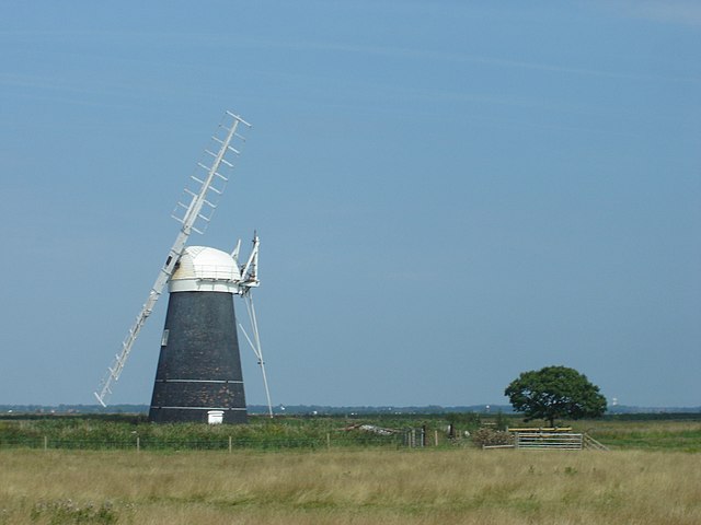
Flixton Road Mill is a tower mill at Bungay, Suffolk, England which has been truncated and converted to residential accommodation. The structure is a Grade II listed building, Flixton Road Mill was built in 1830. It worked by wind until 1918 when it was struck by lightning, later, it was truncated by one storey and converted to residential accommodation. Flixton Road Mill was a six storey tower mill with a boat shaped cap and it had four Patent sails of ten bays and was winded by a fantail. There was a stage at second level and the mill drove three pairs of millstones. Auxiliary power was by an engine, with the drive belt enclosed in a wooden casing. Frederick Robert Burtsal 1868-74 Reference for above, - Windmill World webpage on Flixton Road Mill
2.
Suffolk
–
Suffolk is an East Anglian county of historic origin in England. It has borders with Norfolk to the north, Cambridgeshire to the west, the North Sea lies to the east. The county town is Ipswich, other important towns include Lowestoft, Bury St Edmunds, Newmarket and Felixstowe, the county is low-lying with very few hills, and is largely arable land with the wetlands of the Broads in the north. The Suffolk Coast and Heaths are an Area of Outstanding Natural Beauty, by the fifth century, the Angles had established control of the region. The Angles later became the folk and the south folk. Suffolk and several adjacent areas became the kingdom of East Anglia, Suffolk was originally divided into four separate Quarter Sessions divisions. In 1860, the number of divisions was reduced to two, the eastern division was administered from Ipswich and the western from Bury St Edmunds. Under the Local Government Act 1888, the two divisions were made the administrative counties of East Suffolk and West Suffolk, Ipswich became a county borough. A few Essex parishes were added to Suffolk, Ballingdon-with-Brundon and parts of Haverhill. On 1 April 1974, under the Local Government Act 1972, East Suffolk, West Suffolk, the county was divided into several local government districts, Babergh, Forest Heath, Ipswich, Mid Suffolk, St. Edmundsbury, Suffolk Coastal, and Waveney. This act also transferred some land near Great Yarmouth to Norfolk, in 2007, the Department for Communities and Local Government referred Ipswich Borough Councils bid to become a new unitary authority to the Boundary Committee. The Boundary Committee consulted local bodies and reported in favour of the proposal and it was not, however, approved by the Secretary of State for Communities and Local Government. Beginning in February 2008, the Boundary Committee again reviewed local government in the county, West Suffolk, like nearby East Cambridgeshire, is renowned for archaeological finds from the Stone Age, the Bronze Age, and the Iron Age. Bronze Age artefacts have been found in the area between Mildenhall and West Row, in Eriswell and in Lakenheath, other finds include traces of cremations and barrows. The majority of agriculture in Suffolk is either arable or mixed, Farm sizes vary from anything around 80 acres to over 8,000. Soil types vary from clays to light sands. The continuing importance of agriculture in the county is reflected in the Suffolk Show, although latterly somewhat changed in nature, this remains primarily an agricultural show. Below is a chart of regional gross value added of Suffolk at current basic prices published by Office for National Statistics with figures in millions of British Pounds Sterling, well-known companies in Suffolk include Greene King and Branston Pickle in Bury St Edmunds
3.
United Kingdom Census 2011
–
A census of the population of the United Kingdom is taken every ten years. The 2011 census was held in all countries of the UK on 27 March 2011 and it was the first UK census which could be completed online via the Internet. The Office for National Statistics is the office of the UK Statistics Authority, a non-ministerial department formed in 2008. ONS designs, manages and runs the census in England and Wales, the first results from the 2011 census, age and sex, and occupied households estimates for England and Wales and Northern Ireland, were released on 16 July 2012. The first results for Scotland, and the first UK-wide results, were published on 17 December 2012, more detailed and specialised data were published from 2013. The Registrar General John Rickman conducted the first census of Great Britains population, from 1911 onwards rapid social change, scientific breakthroughs, and major world events affected the structure of the population. The 1971 census was run by the newly created Office of Population Censuses and Surveys, in 1996 the Office for National Statistics was formed by merging the Central Statistical Office, OPCS and the statistics division of the Department of Employment, the first census it ran was in 2001. In 2008 the UK Statistics Authority was established as an independent body, a population census is a key instrument for assessing the needs of local communities. When related to data sources such as housing or agricultural censuses, or sample surveys. Most countries of the world take censuses, the United Nations recommends that countries take a census at least once every ten years, other organisations that use census data include healthcare organisations, community groups, researchers and businesses. The 2011 census for England and Wales included around 25 million households, people could complete and submit their questionnaire online, or fill it in on paper and post it back in a pre-addressed envelope. Guidance was provided online and through the census helpline, completed questionnaires were electronically tracked and field staff followed up with households that did not return a questionnaire. In these cases field staff delivered and collected questionnaires and, where needed, provided advice or assistance in completing the questionnaire, there was a legal requirement to complete the 2011 census questionnaire, under the terms of the Census Act 1920. As at 27 March 2011 everyone who had lived or intended to live in the country for three months or more was required to complete a questionnaire, failure to return a completed questionnaire could lead to a fine and criminal record. The contract is valued at £150 million, approximately one third of the total £482 million census budget, concerns were raised during contract negotiations that the US PATRIOT Act could be used to force Lockheed Martin to reveal census data to US authorities. The Cabinet Office state that Lockheed Martin will develop the systems used to process census data, neither Lockheed Martin UK nor any Lockheed Martin employee will have access to personal Census data. The Office for National Statistics stated that no census information will ever leave the UK or be seen by any American-owned company. Several groups called for a boycott of the census over the involvement of Lockheed Martin, including the Stop the War Coalition, and the Christian thinktank Ekklesia
4.
Ordnance Survey National Grid
–
The Ordnance Survey National Grid reference system is a system of geographic grid references used in Great Britain, different from using Latitude and Longitude. It is often called British National Grid, the Ordnance Survey devised the national grid reference system, and it is heavily used in their survey data, and in maps based on those surveys. Grid references are commonly quoted in other publications and data sources. The Universal Transverse Mercator coordinate system is used to provide references for worldwide locations. European-wide agencies also use UTM when mapping locations, or may use the Military Grid Reference System system, the grid is based on the OSGB36 datum, and was introduced after the retriangulation of 1936–1962. It replaced the previously used Cassini Grid which, up to the end of World War Two, had issued only to the military. The Airy ellipsoid is a regional best fit for Britain, more modern mapping tends to use the GRS80 ellipsoid used by the GPS, the British maps adopt a Transverse Mercator projection with an origin at 49° N, 2° W. Over the Airy ellipsoid a straight grid, the National Grid, is placed with a new false origin. This false origin is located south-west of the Isles of Scilly, the distortion created between the OS grid and the projection is countered by a scale factor in the longitude to create two lines of longitude with zero distortion rather than one. Grid north and true north are aligned on the 400 km easting of the grid which is 2° W. 2° 0′ 5″ W. OSGB36 was also used by Admiralty nautical charts until 2000 after which WGS84 has been used, a geodetic transformation between OSGB36 and other terrestrial reference systems can become quite tedious if attempted manually. The most common transformation is called the Helmert datum transformation, which results in a typical 7 m error from true, the definitive transformation from ETRS89 that is published by the OSGB is called the National Grid Transformation OSTN02. This models the detailed distortions in the 1936–1962 retriangulation, and achieves backwards compatibility in grid coordinates to sub-metre accuracy, the difference between the coordinates on different datums varies from place to place. The longitude and latitude positions on OSGB36 are the same as for WGS84 at a point in the Atlantic Ocean well to the west of Great Britain. In Cornwall, the WGS84 longitude lines are about 70 metres east of their OSGB36 equivalents, the smallest datum shift is on the west coast of Scotland and the greatest in Kent. But Great Britain has not shrunk by 100+ metres, a point near Lands End now computes to be 27.6 metres closer to a point near Duncansby Head than it did under OSGB36. For the first letter, the grid is divided into squares of size 500 km by 500 km, there are four of these which contain significant land area within Great Britain, S, T, N and H. The O square contains an area of North Yorkshire, almost all of which lies below mean high tide
5.
Districts of England
–
The districts of England are a level of subnational division of England used for the purposes of local government. As the structure of government in England is not uniform. Some districts are styled as boroughs, cities, or royal boroughs, these are purely honorific titles, prior to the establishment of districts in the 1890s, the basic unit of local government in England was the parish overseen by the parish church vestry committee. Vestries dealt with the administraction of both parochial and secular governmental matters, parishes were the successors of the manorial system and historically had been grouped into hundreds. Hundreds once exercised some supervising administrative function, however, these powers ebbed away as more and more civic and judicial powers were centred on county towns. From 1834 these parishes were grouped into Poor Law Unions, creating areas for administration of the Poor Law and these areas were later used for census registration and as the basis for sanitary provision. In 1894, based on these earlier subdivisions, the Local Government Act 1894 created urban districts and rural districts as sub-divisions of administrative counties, another reform in 1900 created 28 metropolitan boroughs as sub-divisions of the County of London. Meanwhile, from this date parish-level local government administration was transferred to civil parishes, the setting-down of the current structure of districts in England began in 1965, when Greater London and its 32 London boroughs were created. They are the oldest type of still in use. In 1974, metropolitan counties and non-metropolitan counties were created across the rest of England and were split into metropolitan districts, in London power is now shared again, albeit on a different basis, with the Greater London Authority. During the 1990s a further kind of district was created, the unitary authority, metropolitan boroughs are a subdivision of a metropolitan county. These are similar to unitary authorities, as the county councils were abolished in 1986. Most of the powers of the county councils were devolved to the districts but some services are run by joint boards, the districts typically have populations of 174,000 to 1.1 million. Non-metropolitan districts are second-tier authorities, which share power with county councils and they are subdivisions of shire counties and the most common type of district. These districts typically have populations of 25,000 to 200,000, the number of non-metropolitan districts has varied over time. Initially there were 296, after the creation of unitary authorities in the 1990s and late 2000s and these are single-tier districts which are responsible for running all local services in their areas, combining both county and district functions. They were created in the out of non-metropolitan districts, and often cover large towns. In addition, some of the smaller such as Rutland, Herefordshire
6.
Waveney
–
Waveney is a local government district in Suffolk, England, named after the River Waveney that forms its north-west border. The district council is based in Lowestoft, the settlement in Waveney. The other towns in the district are Beccles, Bungay, Halesworth, the population of the Council at the 2011 Census was 115,254. The last elections to the council were held on 7 May 2015, before the 2011 elections the council was under Conservative Party control. A series of procedural moves led to the formation of a Conservative-led administration, at the 2015 election the Conservatives won an absolute majority, with 27 seats, with Labour winning 20 and the Green Party 1. Outside of Lowestoft there are 58 towns and civil parishes in Waveney, Waveney District Council
7.
Regions of England
–
The regions are the highest tier of sub-national division in England. Between 1994 and 2011, nine regions had officially devolved functions within Government, while they no longer fulfil this role, they continue to be used for statistical and some administrative purposes. They define areas for the purposes of elections to the European Parliament, Eurostat also uses them to demarcate first level Nomenclature of Territorial Units for Statistics regions within the European Union. The regions generally follow the boundaries of the former standard regions, the London region has a directly elected Mayor and Assembly. Six regions have local authority leaders boards to assist with correlating the headline policies of local authorities, the remaining two regions no longer have any administrative functions, having abolished their regional local authority leaders boards. In 1998, regional chambers were established in the eight regions outside of London, the regions also had an associated Government Office with some responsibility for coordinating policy, and, from 2007, a part-time regional minister within the Government. House of Commons regional Select Committees were established in 2009, Regional ministers were not reappointed by the incoming Coalition Government, and the Government Offices were abolished in 2011. Regional development agencies were public bodies established in all nine regions in 1998 to promote economic development and they had certain delegated functions, including administering European Union regional development funds, and received funding the central government as well. After about 500 AD, England comprised seven Anglo-Saxon territories – Northumbria, Mercia, East Anglia, Essex, Kent, the boundaries of some of these, which later unified as the Kingdom of England, roughly coincide with those of modern regions. During Oliver Cromwells Protectorate in the 1650s, the rule of the Major-Generals created 10 regions in England, proposals for administrative regions within England were mooted by the British government prior to the First World War. In 1912 the Third Home Rule Bill was passing through parliament, the Bill was expected to introduce a devolved parliament for Ireland, and as a consequence calls were made for similar structures to be introduced in Great Britain or Home Rule All Round. On 12 September the First Lord of the Admiralty, Winston Churchill, within England, he suggested that London, Lancashire, Yorkshire, and the Midlands would make natural regions. While the creation of regional parliaments never became official policy, it was for a widely anticipated. In 1946 nine standard regions were set up, in central government bodies, statutory undertakings. However, these had declined in importance by the late 1950s, creation of some form of provinces or regions for England was an intermittent theme of post-Second World War British governments. The Redcliffe-Maud Report proposed the creation of eight provinces in England, one-fifth of the advisory councils would be nominees from central government. The boundaries suggested were the eight now existing for economic planning purposes, a minority report by Lord Crowther-Hunt and Alan T. Peacock suggested instead seven regional assemblies and governments within Great Britain, some elements of regional development and economic planning began to be established in England from the mid-1960s onwards
8.
East of England
–
The East of England is one of nine official regions of England at the first level of NUTS for statistical purposes. It was created in 1994 and was adopted for statistics from 1999 and it includes the ceremonial counties of Bedfordshire, Cambridgeshire, Essex, Hertfordshire, Norfolk and Suffolk. Essex has the highest population in the region and its population at the 2011 census was 5,847,000. Bedford, Luton, Basildon, Peterborough, Southend-on-Sea, Norwich, Ipswich, Colchester, Chelmsford, the southern part of the region lies in the London commuter belt. The region has the lowest elevation range in the UK, North Cambridgeshire and the Essex Coast have most of the around 5% of the region which is below 10 metres above sea level. The Fens are partly in North Cambridgeshire which is notable for the lowest point in the country in the land of the village of Holme 2.75 metres below sea level which was once Whittlesey Mere. The highest point is at Clipper Down at 817 ft, in the far corner of the region in the Ivinghoe Hills. In the late 1960s, the Roskill Commission considered Thurleigh in Bedfordshire, Nuthampstead in Hertfordshire, the East of England succeeded the standard statistical region East Anglia. The East of England civil defence region was identical to todays region, England between the Wash and Thames Estuary has since post-Roman times been and continues to be known as East Anglia, including the county traversing the west of this line, Cambridgeshire. Essex, despite meaning East-Saxons, previously formed part of the South East England, as did Bedfordshire and Hertfordshire, the earliest use of the term is from 1695. Charles Davenant, in An essay upon ways and means of supplying the war, wrote, The Eleven Home Counties, then cited a list including these four. The term does not appear to have used in taxation since the 18th century. East Anglia is one of the driest parts of the United Kingdom with average rainfall ranging from 450 mm to 750 mm. This is usually because low pressure systems and weather fronts from the Atlantic have lost a lot of their moisture over land by the time they reach Eastern England, however the Fens in Cambridgeshire are prone to flooding should a strong system affect the area. Northerly winds can also be cold but are not usually as cold as easterly winds, westerly winds bring milder and, typically, wetter weather. Southerly winds usually bring mild air but chill if coming from further east than Spain, spring is a transitional season that can be chilly to start with but is usually warm by late-April/May. The weather at this time is often changeable and occasionally showery, summer is usually warm and continental air from mainland Europe or the Azores High usually leads to at least a few weeks of hot, balmy weather with prolonged warm to hot weather. The number of storms from the Atlantic, such as the remnants of a tropical storm usually coincides with the location of the jet stream
9.
Countries of the United Kingdom
–
The United Kingdom comprises four countries, England, Scotland, Wales and Northern Ireland. Within the United Kingdom, a sovereign state, Northern Ireland, Scotland. England, comprising the majority of the population and area of the United Kingdom, England, Northern Ireland, Scotland and Wales are not themselves listed in the International Organization for Standardization list of countries. However the ISO list of the subdivisions of the UK, compiled by British Standards, Northern Ireland, in contrast, is described as a province in the same lists. Each has separate governing bodies for sports and compete separately in many international sporting competitions. Northern Ireland also forms joint All-Island sporting bodies with the Republic of Ireland for most sports, the Channel Islands and the Isle of Man are dependencies of the Crown and are not part of the UK. Similarly, the British overseas territories, remnants of the British Empire, are not part of the UK, southern Ireland left the United Kingdom under the Irish Free State Constitution Act 1922. * Figures for GVA do not include oil and gas revenues generated beyond the UKs territorial waters, various terms have been used to describe England, Northern Ireland, Scotland and Wales. Wales was described as the country, principality, and dominion of Wales, outside Wales, England was not given a specific name or term. The Laws in Wales Acts have subsequently been repealed, the Acts of Union 1707 refer to both England and Scotland as a part of a united kingdom of Great Britain The Acts of Union 1800 use part in the same way to refer to England and Scotland. The Northern Ireland Act 1998, which repealed the Government of Ireland Act 1920, the Interpretation Act 1978 provides statutory definitions of the terms England, Wales and the United Kingdom, but neither that Act nor any other current statute defines Scotland or Northern Ireland. Use of the first three terms in other legislation is interpreted following the definitions in the 1978 Act and this definition applies from 1 April 1974. United Kingdom means Great Britain and Northern Ireland and this definition applies from 12 April 1927. In 1996 these 8 new counties were redistributed into the current 22 unitary authorities, Scotland, Wales and Northern Ireland are regions in their own right while England has been divided into nine regions. The official term rest of the UK is used in Scotland, for example in export statistics and this term is also used in the context of potential Scottish independence to mean the UK without Scotland. The alternative term Home Nations is sometimes used in sporting contexts, the second, or civic group, contained the items about feeling British, respecting laws and institutions, speaking English, and having British citizenship. Contrariwise, in Scotland and Wales there was a much stronger identification with each country than with Britain, studies and surveys have reported that the majority of the Scots and Welsh see themselves as both Scottish/Welsh and British though with some differences in emphasis. The propensity for nationalistic feeling varies greatly across the UK, and can rise and it reported that 37% of people identified as British, whilst 29% identified as Irish and 24% identified as Northern Irish
10.
England
–
England is a country that is part of the United Kingdom. It shares land borders with Scotland to the north and Wales to the west, the Irish Sea lies northwest of England and the Celtic Sea lies to the southwest. England is separated from continental Europe by the North Sea to the east, the country covers five-eighths of the island of Great Britain in its centre and south, and includes over 100 smaller islands such as the Isles of Scilly, and the Isle of Wight. England became a state in the 10th century, and since the Age of Discovery. The Industrial Revolution began in 18th-century England, transforming its society into the worlds first industrialised nation, Englands terrain mostly comprises low hills and plains, especially in central and southern England. However, there are uplands in the north and in the southwest, the capital is London, which is the largest metropolitan area in both the United Kingdom and the European Union. In 1801, Great Britain was united with the Kingdom of Ireland through another Act of Union to become the United Kingdom of Great Britain and Ireland. In 1922 the Irish Free State seceded from the United Kingdom, leading to the latter being renamed the United Kingdom of Great Britain, the name England is derived from the Old English name Englaland, which means land of the Angles. The Angles were one of the Germanic tribes that settled in Great Britain during the Early Middle Ages, the Angles came from the Angeln peninsula in the Bay of Kiel area of the Baltic Sea. The earliest recorded use of the term, as Engla londe, is in the ninth century translation into Old English of Bedes Ecclesiastical History of the English People. According to the Oxford English Dictionary, its spelling was first used in 1538. The earliest attested reference to the Angles occurs in the 1st-century work by Tacitus, Germania, the etymology of the tribal name itself is disputed by scholars, it has been suggested that it derives from the shape of the Angeln peninsula, an angular shape. An alternative name for England is Albion, the name Albion originally referred to the entire island of Great Britain. The nominally earliest record of the name appears in the Aristotelian Corpus, specifically the 4th century BC De Mundo, in it are two very large islands called Britannia, these are Albion and Ierne. But modern scholarly consensus ascribes De Mundo not to Aristotle but to Pseudo-Aristotle, the word Albion or insula Albionum has two possible origins. Albion is now applied to England in a poetic capacity. Another romantic name for England is Loegria, related to the Welsh word for England, Lloegr, the earliest known evidence of human presence in the area now known as England was that of Homo antecessor, dating to approximately 780,000 years ago. The oldest proto-human bones discovered in England date from 500,000 years ago, Modern humans are known to have inhabited the area during the Upper Paleolithic period, though permanent settlements were only established within the last 6,000 years
11.
United Kingdom
–
The United Kingdom of Great Britain and Northern Ireland, commonly known as the United Kingdom or Britain, is a sovereign country in western Europe. Lying off the north-western coast of the European mainland, the United Kingdom includes the island of Great Britain, Northern Ireland is the only part of the United Kingdom that shares a land border with another sovereign state—the Republic of Ireland. The Irish Sea lies between Great Britain and Ireland, with an area of 242,500 square kilometres, the United Kingdom is the 78th-largest sovereign state in the world and the 11th-largest in Europe. It is also the 21st-most populous country, with an estimated 65.1 million inhabitants, together, this makes it the fourth-most densely populated country in the European Union. The United Kingdom is a monarchy with a parliamentary system of governance. The monarch is Queen Elizabeth II, who has reigned since 6 February 1952, other major urban areas in the United Kingdom include the regions of Birmingham, Leeds, Glasgow, Liverpool and Manchester. The United Kingdom consists of four countries—England, Scotland, Wales, the last three have devolved administrations, each with varying powers, based in their capitals, Edinburgh, Cardiff and Belfast, respectively. The relationships among the countries of the UK have changed over time, Wales was annexed by the Kingdom of England under the Laws in Wales Acts 1535 and 1542. A treaty between England and Scotland resulted in 1707 in a unified Kingdom of Great Britain, which merged in 1801 with the Kingdom of Ireland to form the United Kingdom of Great Britain and Ireland. Five-sixths of Ireland seceded from the UK in 1922, leaving the present formulation of the United Kingdom of Great Britain, there are fourteen British Overseas Territories. These are the remnants of the British Empire which, at its height in the 1920s, British influence can be observed in the language, culture and legal systems of many of its former colonies. The United Kingdom is a country and has the worlds fifth-largest economy by nominal GDP. The UK is considered to have an economy and is categorised as very high in the Human Development Index. It was the worlds first industrialised country and the worlds foremost power during the 19th, the UK remains a great power with considerable economic, cultural, military, scientific and political influence internationally. It is a nuclear weapons state and its military expenditure ranks fourth or fifth in the world. The UK has been a permanent member of the United Nations Security Council since its first session in 1946 and it has been a leading member state of the EU and its predecessor, the European Economic Community, since 1973. However, on 23 June 2016, a referendum on the UKs membership of the EU resulted in a decision to leave. The Acts of Union 1800 united the Kingdom of Great Britain, Scotland, Wales and Northern Ireland have devolved self-government
12.
Postcodes in the United Kingdom
–
Postal codes used in the United Kingdom are known as postcodes. They are alphanumeric and were adopted nationally between 11 October 1959 and 1974, having been devised by the GPO, a full postcode is known as a postcode unit and designates an area with a number of addresses or a single major delivery point. For example, the postcode of the University of Roehampton in London is SW15 5PU, the postcode of GCHQ is GL51 0EX, where GL signifies the postal town of Gloucester. The postal town refers to an area and does not relate to a specific town. GL51 is one of the postcodes for the town of Cheltenham which is where GCHQ is located, the London post town covers 40% of Greater London. On inception it was divided into ten districts, EC, WC, N, NE, E, SE, S, SW, W. The S and NE sectors were later abolished and these divisions changed little, usually only changed for operational efficiency. Some older road signs in Hackney still indicate the North East sector/district, following the successful introduction of postal districts in London, the system was extended to other large towns and cities. Liverpool was divided into Eastern, Northern, Southern and Western districts in 1864/65, in 1917 Dublin – then still part of the United Kingdom – was divided into numbered postal districts. These continue in use in a form by An Post. In 1923 Glasgow was divided in a way to London. In January 1932 the Postmaster General approved the designation of some urban areas into numbered districts. In November 1934 the Post Office announced the introduction of numbered districts in every town in the United Kingdom large enough to justify it. Pamphlets were issued to each householder and business in ten areas notifying them of the number of the district in which their premises lay, the pamphlets included a map of the districts, and copies were made available at local head post offices. The public were invited to include the district number in the address at the head of letters. A publicity campaign in the following year encouraged the use of the district numbers, the slogan for the campaign was For speed and certainty always use a postal district number on your letters and notepaper. A poster was fixed to every box in the affected areas bearing the number of the district. Every post office in the district was also to display this information
13.
Telephone numbers in the United Kingdom
–
Telephone numbers in the United Kingdom are administered by the UK governments Office of Communications. For this purpose Ofcom established a telephone numbering plan, known as the National Telephone Numbering Plan, since 28 April 2001, almost all geographic numbers and most non-geographic numbers have 9 or 10 national numbers after the 0 trunk code. All mobile telephone numbers have 10 national numbers after the 0 trunk code, regions with shorter area codes, typically large cities, permit the allocation of more telephone numbers as the local number portion has more digits. Local customer numbers are four to eight figures long, the total number of digits is ten, but in a very few areas the total may be nine digits. The area code is referred to as an STD or a dialling code in the UK. The code allocated to the largest population is for London, the code allocated to the largest area is for all of Northern Ireland. The UK Numbering Plan also applies to three British Crown dependencies—Jersey, Guernsey and the Isle of Man—even though they are not part of the UK itself. Possible number formats for UK telephone numbers are as follows, Number ranges starting 01 can have NSN length as 10 or 9 digits, the 0800 range can have NSN length as 10,9 or 7 digits. The 0845 range can have NSN length as 10 or 7 digits, the 0500 range has NSN length as 9 digits only. There are no numbers in the UK with an NSN length of 8 digits. Geographic telephone numbers in the UK always have nine or ten digits, four-digit area codes have either six-digit subscriber numbers or a mix of five- and six-digit subscriber numbers. Xxxxxx This is the used by most areas. It has an area code and a six digit subscriber number. These area codes were changed by adding a 1 directly after the zero as a part of PhONEday in 1995. Just short of 581 areas use this format, and the area range from 01200 to 01998. A small number of areas also have a few subscriber numbers that have only five digits. That is, almost all area codes now have only six digit local numbers, six of the four-digit area codes are known as mixed areas as they share those four digits with the twelve five-digit area codes. The numbers therefore have only nine digits after the initial zero trunk code and these area codes were changed by adding a 1 directly after the initial zero as a part of PhONEday in 1995
14.
Suffolk Constabulary
–
Suffolk Constabulary is the territorial police force responsible for policing Suffolk in East Anglia, England. Suffolk Constabulary is responsible for policing an area of 939,510 acres, the area covered is principally rural and coastal and the force has two territorial areas, Eastern and Western. The Eastern Area HQ is at Halesworth, the Western Area HQ at Bury St Edmunds, each area is divided into sectors, with boundaries matching those of local district or borough councils. There are a total of 14 sectors across the county, each commanded by an inspector or chief inspector. As of 2 July 2005, Suffolk Constabulary had 1,305 police officers and 841 police staff, the current Suffolk Police and Crime Commissioner is Tim Passmore of the Conservative Party. The retirement of Douglas Paxton after a period of ill health has now lead to the appointment of previously T/CC Gareth Wilson to the role of the new Chief Constable. The National Police Air Service currently operates the helicopter from Wattisham Airfield serving Suffolk and this will then leave Boreham near Chelmsford as the closest base to Suffolk. As part of continued savings for Suffolk Constabulary, In 2011 the Suffolk and Norfolk Constabularies dogs sections collaborated, the new unit consists of 25 Police Constable dog handlers and overseen by two Police Sergeants and an Inspector. The unit uses Home Office licensed general purpose dogs that are either German Shepherds or Belgium Malinois, in addition a number of handlers operate specialist search dogs capable of detecting either cash, drugs, firearms or explosives. For this role the Constabulary uses a number of breeds including Spaniels, Officers part of the Traffic Police are responsible for the policing the two main road networks in Suffolk, the A14 and the A12, in addition to the countys highways. The department uses Automatic Number Plate Recognition on many of the vehicles to reduce vehicle crime. Denying criminals use of the roads, preventing anti-social use of motor vehicles. Enhancing public confidence and reassurance by patrolling the county’s roads, the firearms unit in Suffolk Police is known as the Tactical Firearms Unit made up Authorised Firearms Officers and also have a specialist rifle team. The TFU are trained in management and method of entry, they are trained to use specialist equipment to gain quick entry into properties. Armoury, Glock 17 self-loading pistol G36 Carbine TMR17. 62mm rifle Heckler & Koch 5.56 mm rifle Remington pump action shotgun, a more recent addition is the Heckler and Koch baton gun. This fires a plastic baton round and provides officers with a less lethal option, TFU officers also have the X26 Taser available for deployment as another less lethal option. The Taser operates by discharging two barbs, which attach to the clothing, or penetrate the skin of the person and this creates a circuit through which 50000 volts of electricity is passed causing temporary incapacitation. The force formed from the merger of West Suffolk Constabulary and East Suffolk Constabulary and those forces had previously been merged in 1869 and the split again in 1899
15.
Fire services in the United Kingdom
–
The fire services in the United Kingdom operate under separate legislative and administrative arrangements in England and Wales, Northern Ireland, and Scotland. Emergency cover is provided by over fifty fire and rescue services, many FRS were previously known as brigades or county fire services, but almost all now use the standard terminology. They are distinct from and governed by an authority, which is the legislative, public and administrative body. Fire authorities in England and Wales, and therefore fire and rescue services, Scotland and Northern Ireland have centralised fire and rescue services, and so their authorities are effectively committees of the devolved parliaments. The total budget for services in 2014-15 was £2.9 billion. The devolved government in Scotland has an agency, HMFSI Scotland. This Act provided for centralised co-ordination of fire brigades in Great Britain,1947, Fire Services Act 1947 This Act transferred the functions of the National Fire Service to local authorities. Now repealed entirely in England and Wales by Schedule 2 of the Fire,1959, Fire Services Act 1959 This Act amended the 1947 Act, it dealt with pensions, staffing arrangements and provision of services by other authorities. It was repealed in England and Wales along with the 1947 Act,1999, Greater London Authority Act 1999 This act was necessary to allow for the formation of the Greater London Authority and in turn the London Fire and Emergency Planning Authority. In 2002, there was a series of fire strikes. In December 2002, the Independent Review of the Fire Service was published with the action still ongoing. Bains report ultimately led to a change in the relating to firefighting. 2002, Independent Review of the Fire Service published 2004, Fire and Rescue Services Act 2004, generally only applying to England and it came into force on 1 October 2006. The DfCLG has published a set of guides for non-domestic premises,2006, The Government of Wales Act 2006 gave the National Assembly for Wales powers to pass laws on Fire, promotion of fire safety otherwise than by prohibition or regulation. But does not prevent future legislation being passed by the UK government which applies to two or more constituent countries, There are further plans to modernise the fire service according to the Local Government Association. The fire service in England and Wales is scrutinised by a House of Commons select committee, in June 2006, the fire and rescue service select committee, under the auspices of the Communities and Local Government Committee, published its latest report. For example, where FRSs were historically inspected by HMFSI, much of this work is now carried out by the National Audit Office, Fire Control On 8 February 2010 the House of Commons Communities and Local Government Select Committee heard evidence on the Fire Control project. Called to give evidence were Cllr Brian Coleman and Cllr James Pearson from the Local Government Association, also giving evidence Matt Wrack from the Fire Brigades Union and John Bonney Chief Fire Officers Association
16.
Emergency medical services in the United Kingdom
–
Emergency care including ambulance and emergency department treatment is free to everyone, regardless of immigration or visitor status. The NHS commissions most emergency services through the 14 NHS organisations with ambulance responsibility across the UK. As with other services, the public normally access emergency medical services through one of the valid emergency telephone numbers. This led to the formation of predominantly county based ambulance services, which gradually merged up and changed responsibilities until 2006, when there were 31 NHS ambulance trusts in England. Following further changes as part of the NHS foundation trust pathway, the commissioners in each region are responsible for contracting with a suitable organisation to provide ambulance services within their geographical territory. The primary contract for each area is held by a public NHS body, of which there are 11 in England. The service was operated before reorganisation in 1974 by the St Andrews’ Ambulance Association under contract to the Secretary of State for Scotland, the Northern Ireland Ambulance Service was established in 1995 by parliamentary order, and serves the whole of Northern Ireland. The Welsh Ambulance Service NHS Trust was established on 1 April 1998, there is a large market for private and voluntary ambulance services, with the sector being worth £800m to the UK economy in 2012. This places the voluntary providers in direct competition with private services, expenditure on private ambulances in England increased from £37m in 2011−12 to £67. 5m in 2013/4, rising in London from £796,000 to more than £8. 8m. In 2014−15, these 10 ambulance services spent £57.6 million on 333,329 callouts of private or voluntary services - an increase of 156% since 2010−11, in 2013, the CQC found 97% of private ambulance services to be providing good care. These private, registered services are represented by the Independent Ambulance Association, there are also a number of unregistered services operating, who do not provide ambulance transport, but only provide response on an event site. These firms are not regulated, and are not subject to the checks as the registered providers, although they may operate similar vehicles. There are a number of ambulance providers, sometimes known as Voluntary Aid Services or Voluntary Aid Societies, with the main ones being the British Red Cross. The history of the ambulance services pre-dates any government organised service. As they are in competition for work with the private ambulance providers. Voluntary organisations have also provided cover for the public when unionised NHS ambulance trust staff have taken industrial action, there are a number of smaller voluntary ambulance organisations, fulfilling specific purposes, such as Hatzola who provide emergency medical services to the orthodox Jewish community in some cities. These have however run into difficulties due to use of vehicles not legally recognised as ambulances, all emergency medical services in the UK are subject to a range of legal and regulatory requirements, and in many cases are also monitored for performance. This framework is largely statutory in nature, being mandated by government through a range of primary and secondary legislation and this requires all providers to register, to meet certain standards of quality, and to submit to inspection of those standards
17.
East of England Ambulance Service
–
These consist of 5.8 million people and 7,500 square miles. It is one of 10 Ambulance Trusts providing England with emergency medical services, there is no charge to patients for use of the service, and under the Patients Charter every person in the United Kingdom has the right to the attendance of an ambulance in an emergency. The Trust controls the mobilisation of Immediate Care charities throughout its area and these include Magpas, SARS, NARS and East Anglian Air Ambulance. The result was a service covering an area of over 7,500 square miles with a population of 5.8 million people, the East Anglian Ambulance NHS Trust had been formed in 1994 from the three-way merger of Cambridgeshire, Norfolk and Suffolk Ambulance Services. In 2015/16, the trust received 1,037,119 emergency calls, the trust arrived at 66. 9% of emergency Red 1 calls within eight minutes, and 59. 9% of emergency Red 2 calls within eight minutes. Overall, the trust arrived to 90% of Red 1/2 calls within 19 minutes, EEAST employs more than 4,000 staff and has around 1,500 volunteers. The EEAST uses Mercedes Sprinters as their front-line emergency ambulances, and use Ford Mondeos, renault Masters are used as Patient Transport Service vehicles. Iveco Dailys and Land Rover Discoverys are used as Hazardous Area Response Team vehicles, in 2013-14 the Trust missed all of its targets in Cambridgeshire and Peterborough. 73. 6% of red 1 calls for immediately life-threatening situations were met within eight minutes against a target of 75%,69. 4% of red 2 calls, which may be life-threatening but less time critical were responded to within eight minutes against a 75% target. In north Norfolk, rapid responses during one month were as low as 25%, according to the Clinical Commissioning Group performance had deteriorated overall in comparison to prior year at both regional and local level. In August 2014, the Trust was fined £1. 2m over these failures and it was also fined £300,000 over turnaround times at hospitals. The fines were accrued between April and July 2014, EEAST, which handles more than 900,000 emergency 999 calls a year, said it was recruiting hundreds of new staff and investing in new ambulances. In a statement in November 2014, Chief executive Anthony Marsh blamed EEASTS’ continued failure to meet its emergency response time targets on a lack of staff. In October 2014, EEAST apologised after claims were published in a newspaper that a body had been left lying next to dustbins at its station in Ely. Chief executive Anthony Marsh said the Trust was very sorry for what happened and had started a thorough investigation, an EEAST spokesman confirmed the investigation involved the transportation of a deceased patient, but said he could not comment further as inquiries were ongoing. The newspaper which published the claims said it had done so after being approached by a whistleblower
18.
East of England (European Parliament constituency)
–
East of England is a constituency of the European Parliament. It currently elects 7 MEPs using the method of party-list proportional representation. The constituency corresponds to the East of England region of the United Kingdom, comprising the counties of Bedfordshire, Cambridgeshire, Essex, Hertfordshire. It was formed as a result of the European Parliamentary Elections Act 1999, elected candidates are shown in bold. Brackets indicate the number of votes per seat won
19.
Waveney (UK Parliament constituency)
–
Waveney is a constituency represented in the House of Commons of the UK Parliament since 2010 by Peter Aldous, a Conservative. 1997–2010, The District of Waveney except the wards of Blything, Halesworth, the seat is based on the coastal town of Lowestoft, which today is generally Labour-voting, because of its recent history as a declining seaside resort, fishing and industrial town. However, the constituency also takes in the towns of Beccles, Bungay. These along with the inland rural villages are considerably more supportive of Conservatives. Waveney has been a bellwether since its creation, swinging heavily in line with the mood of the nation, fittingly,2010 saw a marginal majority and the national result was a hung parliament with the Conservative Party the largest party. 2010 here was the Labour Partys second highest share of the vote in the narrow, bob Blizzard served as a senior Government Whip from 2008 until 2010 when he lost at the election that May. The seat is based around the town of Lowestoft, and includes several market towns. Workless claimants who were registered jobseekers were in November 2012 higher than the average of 3. 8%. This compares more unfavourably to the average of 3. 2%. List of Parliamentary constituencies in Suffolk
20.
Geographic coordinate system
–
A geographic coordinate system is a coordinate system used in geography that enables every location on Earth to be specified by a set of numbers, letters or symbols. The coordinates are chosen such that one of the numbers represents a vertical position. A common choice of coordinates is latitude, longitude and elevation, to specify a location on a two-dimensional map requires a map projection. The invention of a coordinate system is generally credited to Eratosthenes of Cyrene. Ptolemy credited him with the adoption of longitude and latitude. Ptolemys 2nd-century Geography used the prime meridian but measured latitude from the equator instead. Mathematical cartography resumed in Europe following Maximus Planudes recovery of Ptolemys text a little before 1300, in 1884, the United States hosted the International Meridian Conference, attended by representatives from twenty-five nations. Twenty-two of them agreed to adopt the longitude of the Royal Observatory in Greenwich, the Dominican Republic voted against the motion, while France and Brazil abstained. France adopted Greenwich Mean Time in place of local determinations by the Paris Observatory in 1911, the latitude of a point on Earths surface is the angle between the equatorial plane and the straight line that passes through that point and through the center of the Earth. Lines joining points of the same latitude trace circles on the surface of Earth called parallels, as they are parallel to the equator, the north pole is 90° N, the south pole is 90° S. The 0° parallel of latitude is designated the equator, the plane of all geographic coordinate systems. The equator divides the globe into Northern and Southern Hemispheres, the longitude of a point on Earths surface is the angle east or west of a reference meridian to another meridian that passes through that point. All meridians are halves of great ellipses, which converge at the north and south poles, the prime meridian determines the proper Eastern and Western Hemispheres, although maps often divide these hemispheres further west in order to keep the Old World on a single side. The antipodal meridian of Greenwich is both 180°W and 180°E, the combination of these two components specifies the position of any location on the surface of Earth, without consideration of altitude or depth. The grid formed by lines of latitude and longitude is known as a graticule, the origin/zero point of this system is located in the Gulf of Guinea about 625 km south of Tema, Ghana. To completely specify a location of a feature on, in, or above Earth. Earth is not a sphere, but a shape approximating a biaxial ellipsoid. It is nearly spherical, but has an equatorial bulge making the radius at the equator about 0. 3% larger than the radius measured through the poles, the shorter axis approximately coincides with the axis of rotation
21.
Beccles
–
Beccles is a market town and civil parish in the Waveney District of the English county of Suffolk. Nearby towns include Lowestoft to the east and Great Yarmouth to the northeast, the town lies on the River Waveney on the edge of The Broads National Park. It had a population at the 2011 census of 10,123, Worlingham is a suburb of Beccles. The combined population of Beccles and Worlingham is 13,868, Beccles is twinned with Petit-Couronne in France. The name is conjectured to be derived from Becc-Liss*, once a flourishing Anglian riverport, it lies in the Waveney valley and is a popular boating centre. The town was granted its Charter in 1584 by Elizabeth I, Sir John Leman was a tradesman from Beccles who became Lord Mayor of London. Long associated with Beccles is the Peck family, among those Pecks who have made a place in history is the Rev. Robert Peck then elected to return to Hingham, Norfolk, and resumed as rector of St Andrews Church. He died in Hingham but left descendants in America, including his brother Joseph Peck, roberts daughter Ann Peck also remained in Massachusetts, and married John Mason, who led colonial forces in the Pequot War. In 1794, François-René de Chateaubriand, while in exile, taught here French language and he fell in love with Charlotte Ives, daughter of Bungays reverend. The successor civil parish has adopted town status, there is an 18th-century octagonal Town Hall. The townscape is dominated by the detached sixteenth-century bell tower of St Michaels church, like the main body of the church, the tower is Perpendicular Gothic in style and is 97 ft tall. The interior of the church was damaged by fire in 1586. The tower is not attached to the church and at the end of the church as the correct end would be too close to a large cliff. It was at church in 1749 that the mother of Horatio Nelson, Catherine Suckling. The Suffolk poet George Crabbe married Sarah Elmy at Beccles church in the 18th century, the town is bypassed to the north by the A146 road between Norwich in Norfolk and Lowestoft in Suffolk. The bypass was built in the 1980s and the road previously ran through the town. The A145 runs from the A146 through the centre and links with the A12 at Blythburgh,11 miles to the south of Beccles. A number of bus services link the town with both Norwich and Lowestoft as well as surrounding villages, many of the modern streets have the suffix gate, for example, Hulvergate, Smallgate and Blyburgate
22.
The Broads
–
The Broads are a network of mostly navigable rivers and lakes in the English counties of Norfolk and Suffolk. The lakes, known locally as broads, were formed by the flooding of peat workings, the Broads, and some surrounding land, were constituted as a special area with a level of protection equivalent to a national park by the Norfolk and Suffolk Broads Act 1988. The Broads Authority, a statutory authority responsible for managing the area. The total area is 303 square kilometres, most of which is in Norfolk, there are seven rivers and 63 broads, mostly less than 4 metres deep. Thirteen broads are generally open to navigation, with a further three having navigable channels, some broads have navigation restrictions imposed on them in autumn and winter. Although the terms Norfolk Broads and Suffolk Broads are used to specific areas within the two counties respectively, the whole area is frequently referred to as the Norfolk Broads. Because of its navigation role the Broads Authority was established under its own legislation on 1 April 1989, the Broads Authority Act 2009, which was promoted through Parliament by the authority, is intended to improve public safety on the water. This followed a consultation which resulted in support from 79% of consultees, including unanimous support from the 14 UK national parks. Defra, the Government department responsible for the parks, also expressed it was content that the Authority would make its own decision on the matter. In response to this the Broads Authority has stated that its three purposes will remain in balance and that the branding is simply for marketing the National Park qualities of the Broads. The Broads are administered by the Broads Authority, Special legislation gives the navigation of the waterways equal status with the conservation and public enjoyment of the area. For many years the known as broads were regarded as natural features of the landscape. It was only in the 1960s that Dr Joyce Lambert proved that they were artificial features, in the Middle Ages the local monasteries began to excavate the peatlands as a turbary business, selling fuel to Norwich and Great Yarmouth. Norwich Cathedral took 320,000 tonnes of peat a year, then the sea levels began to rise, and the pits began to flood. Despite the construction of windpumps and dykes, the continued and resulted in the typical Broads landscape of today, with its reedbeds, grazing marshes. Various attempts were made to extend the navigable rivers, the longest-lasting was on the River Waveney, where an Act of Parliament passed on 17 March 1670 authorised improvements which included three locks, at Geldeston, Ellingham and Wainford. The head of navigation became a new staithe at Bungay, the new section was a private navigation which was not controlled by the Yarmouth Haven and Pier Commissioners, who had responsibility for the rest of the Broadland rivers. The next attempt was to extend navigation on the River Bure from Coltishall to Aylsham, five locks were built, to bypass mills, at Coltishall, Oxnead Lamas, Oxnead, Burgh and Aylsham
23.
Meander
–
A meander, in general, is a bend in a sinuous watercourse or river. A meander forms when moving water in a stream erodes the outer banks and widens its valley, a stream of any volume may assume a meandering course, alternately eroding sediments from the outside of a bend and depositing them on the inside. The result is a pattern as the stream meanders back. When a meander gets cut off from the stream, an oxbow lake forms. Over time meanders migrate downstream, sometimes in such a time as to create civil engineering problems for local municipalities attempting to maintain stable roads. There is not yet full consistency or standardization of scientific terminology used to describe watercourses, a variety of symbols and schemes exist. Parameters based on mathematical formulae or numerical data vary as well, unless otherwise defined in a specific scheme meandering and sinuosity here are synonymous and mean any repetitious pattern of bends, or waveforms. In some schemes, meandering applies only to rivers with exaggerated circular loops or secondary meanders, sinuosity is one of the channel types that a stream may assume over all or part of its course. All streams are sinuous at some time in their history over some part of their length. The term derives from the Meander River located in present-day Turkey and known to the Ancient Greeks as Μαίανδρος Maiandros and its course is so exceedingly winding that everything winding is called meandering. The Meander River is located south of Izmir, east of the ancient Greek town of Miletus, now, Milet and it flows through a graben in the Menderes Massif, but has a flood plain much wider than the meander zone in its lower reach. Its modern Turkish name is the Büyük Menderes River, when a fluid is introduced to an initially straight channel which then bends, the sidewalls induce a pressure gradient that causes the fluid to alter course and follow the bend. From here, two opposing processes occur, irrotational flow and secondary flow, for a river to meander, secondary flow must dominate. Irrotational flow, From Bernoullis equations, high pressure results in low velocity, therefore, in the absence of secondary flow we would expect low fluid velocity at the outside bend and high fluid velocity at the inside bend. This classic fluid mechanics result is irrotational vortex flow, in the context of meandering rivers, its effects are dominated by those of secondary flow. Secondary flow, A force balance exists between pressure forces pointing to the bend of the river and centrifugal forces pointing to the outside bend of the river. In the context of meandering rivers, a boundary layer exists within the layer of fluid that interacts with the river bed. Inside that layer and following standard boundary-layer theory, the velocity of the fluid is effectively zero, centrifugal force, which depends on velocity, is also therefore effectively zero
24.
River Waveney
–
The Waveney is a river which forms the boundary between Suffolk and Norfolk, England, for much of its length within the Broads. The source of the River Waveney is a ditch on the east side of the B1113 road between the villages of Redgrave, Suffolk and South Lopham, Norfolk. The ditch on the side of the road is the source of the River Little Ouse which continues the county boundary and, via the Great Ouse. It is thus claimed that during periods of heavy rainfall Norfolk can be considered to be an island, the explanation of this oddity is that the valley in which the rivers rise was formed, not by these rivers but by water spilling from Lake Fenland. This was a lake of the Devensian glacial, fifteen or twenty thousand years ago. This valley was its spillway into the southern North Sea basin, the river rises close to the 82-foot contour, and flows in an easterly direction though the towns of Diss, Bungay and Beccles. From its source it forms the boundary of Bressingham and Roydon before it reaches Diss. At Scole it is crossed by the course of a Roman road, there is a weir at Billingford and Billingford Windmill is situated a little to the north of the river. Beyond Billingford Bridge the River Dove, flowing northwards from Eye, joins on the bank, the Mid Suffolk Footpath crosses. It turns to the north-east to reach Brockdish and Needham before passing to the south of Harleston, there are several lakes on the south bank, the largest covering 100 acres, which were once Weybread Gravel Pits, but are now used for fishing. Below the lakes are the remains of a Cluniac Priory and the drained area of Mendham Marshes. Mendham, which is the birthplace of the artist Alfred Munnings, lies on the Suffolk bank, Wortwell is in Norfolk, in 1869, Homersfield Bridge, one of the first bridges to be constructed from concrete and iron was built across the river here. It was commissioned by Sir Shafto Adair, had a span of 50 feet and it is now the oldest concrete bridge in England and is a Grade II* listed structure. Road traffic was diverted onto a new bridge in 1970 and it was acquired by Norfolk County Council in 1994, at Earsham the Otter Trust had one of its three UK centres, which opened in 1978 and closed in 2006, having successfully boosted otter numbers on the river. This has now reopened as the River Waveney Study Centre, managed by the River Waveney Trust, at Bungay, the historic head of navigation, the Waveney forms a wide oxbow meander, carrying with it the Norfolk/Suffolk border. Next come Ditchingham, Broome and Ellingham before Geldeston, where an isolated pub stands next to the site of a lock and this is the current limit of navigation for craft larger than a rowing or paddling boat and at this point the Waveney becomes a tidal river. A short way further along is a dyke that leads to the village, gillingham comes next before the river gathers waters at Beccles, as it enters the Broads. Beccles was a port for many years and the parents of Lord Nelson were married in the church of St Michael
25.
Old English
–
Old English or Anglo-Saxon is the earliest historical form of the English language, spoken in England and southern and eastern Scotland in the early Middle Ages. It was brought to Great Britain by Anglo-Saxon settlers probably in the mid 5th century, Old English developed from a set of Anglo-Frisian or North Sea Germanic dialects originally spoken by Germanic tribes traditionally known as the Angles, Saxons, and Jutes. As the Anglo-Saxons became dominant in England, their language replaced the languages of Roman Britain, Common Brittonic, a Celtic language, Old English had four main dialects, associated with particular Anglo-Saxon kingdoms, Mercian, Northumbrian, Kentish and West Saxon. It was West Saxon that formed the basis for the standard of the later Old English period, although the dominant forms of Middle. The speech of eastern and northern parts of England was subject to strong Old Norse influence due to Scandinavian rule, Old English is one of the West Germanic languages, and its closest relatives are Old Frisian and Old Saxon. Like other old Germanic languages, it is different from Modern English. Old English grammar is similar to that of modern German, nouns, adjectives, pronouns, and verbs have many inflectional endings and forms. The oldest Old English inscriptions were using a runic system. Old English was not static, and its usage covered a period of 700 years, from the Anglo-Saxon settlement of Britain in the 5th century to the late 11th century, some time after the Norman invasion. While indicating that the establishment of dates is a process, Albert Baugh dates Old English from 450 to 1150, a period of full inflections. Perhaps around 85 per cent of Old English words are no longer in use, Old English is a West Germanic language, developing out of Ingvaeonic dialects from the 5th century. It came to be spoken over most of the territory of the Anglo-Saxon kingdoms which became the Kingdom of England and this included most of present-day England, as well as part of what is now southeastern Scotland, which for several centuries belonged to the Anglo-Saxon kingdom of Northumbria. Other parts of the island – Wales and most of Scotland – continued to use Celtic languages, Norse was also widely spoken in the parts of England which fell under Danish law. Anglo-Saxon literacy developed after Christianisation in the late 7th century, the oldest surviving text of Old English literature is Cædmons Hymn, composed between 658 and 680. There is a corpus of runic inscriptions from the 5th to 7th centuries. The Old English Latin alphabet was introduced around the 9th century, with the unification of the Anglo-Saxon kingdoms by Alfred the Great in the later 9th century, the language of government and literature became standardised around the West Saxon dialect. In Old English, typical of the development of literature, poetry arose before prose, a later literary standard, dating from the later 10th century, arose under the influence of Bishop Æthelwold of Winchester, and was followed by such writers as the prolific Ælfric of Eynsham. This form of the language is known as the Winchester standard and it is considered to represent the classical form of Old English
26.
Bungay Castle
–
Bungay Castle is in the town of Bungay, Suffolk by the River Waveney. Originally this was a Norman castle built by Roger Bigod of Norfolk, around 1100, which took advantage of the protection given by the curve of the River Waveney. Rogers son, Hugh Bigod, was a prominent player in the war years of the Anarchy. Henry confiscated Bungay, returning it in 1164, Hugh went on to build a large square Norman keep on the site in 1165. It is not recorded how much it cost to build the keep, Hugh ended up on the losing side in the Revolt of 1173–1174, Bungay was besieged, mined and ultimately destroyed by royal forces. The site was restored yet again to the Bigods and was further developed in 1294 by Roger Bigod, 5th Earl of Norfolk. Roger fell out with Edward I and after his death the castle reverted to the Crown, falling into disrepair, from 1483, it was primarily owned by the Dukes of Norfolk until the 20th century. Restoration work on the began in 1934, following work by the amateur archaeologist Leonard Cane. The curtain walls and the towers of the gatehouse remain today. Bungay Castle was given to the town of Bungay by the Duke of Norfolk in 1987, the castle is a Grade I listed building. Castles in Great Britain and Ireland List of castles in England Braun, Bungay Castle, report on the excavations, Proceedings of the Suffolk Institute of Archaeology and History 22. English Castles, a Guide by Counties, fry, Plantagenet Somerset, The David & Charles Book of Castles, David & Charles,1980
27.
Normans
–
The Normans were the people who, in the 10th and 11th centuries, gave their name to Normandy, a region in France. They were descended from Norse raiders and pirates from Denmark, Iceland and Norway who, under their leader Rollo, through generations of assimilation and mixing with the native Frankish and Gallo-Roman populations, their descendants gradually adopted the Carolingian-based cultures of West Francia. The distinct cultural and ethnic identity of the Normans emerged initially in the first half of the 10th century, the Norman dynasty had a major political, cultural and military impact on medieval Europe and even the Near East. The Normans were famed for their spirit and eventually for their Christian piety. They adopted the Gallo-Romance language of the Frankish land they settled, their becoming known as Norman, Normaund or Norman French. The Normans are noted both for their culture, such as their unique Romanesque architecture and musical traditions, and for their significant military accomplishments and their chief men were specially lavish through their desire of good report. They were, moreover, a race skillful in flattery, given to the study of eloquence, so that the boys were orators. They were enduring of toil, hunger, and cold whenever fortune laid it on them, given to hunting and hawking, delighting in the pleasure of horses, and of all the weapons and garb of war. The treaty offered Rollo and his men the French lands between the river Epte and the Atlantic coast in exchange for their protection against further Viking incursions. The area corresponded to the part of present-day Upper Normandy down to the river Seine. The territory was equivalent to the old province of Rouen. Before Rollos arrival, its populations did not differ from Picardy or the Île-de-France, the Norman language was forged by the adoption of the indigenous langue doïl branch of Romance by a Norse-speaking ruling class, and it developed into the regional language that survives today. The Normans thereafter adopted the growing feudal doctrines of the rest of France, the new Norman rulers were culturally and ethnically distinct from the old French aristocracy, most of whom traced their lineage to Franks of the Carolingian dynasty. Most Norman knights remained poor and land-hungry, and by 1066 Normandy had been exporting fighting horsemen for more than a generation, many Normans of Italy, France and England eventually served as avid Crusaders under the Italo-Norman prince Bohemund I and the Anglo-Norman king Richard the Lion-Heart. Opportunistic bands of Normans successfully established a foothold in Southern Italy, probably as the result of returning pilgrims stories, the Normans entered Southern Italy as warriors in 1017 at the latest. In 999, according to Amatus of Montecassino, Norman pilgrims returning from Jerusalem called in at the port of Salerno when a Saracen attack occurred. The Normans fought so valiantly that Prince Guaimar III begged them to stay, the Hauteville family achieved princely rank by proclaiming prince Guaimar IV of Salerno Duke of Apulia and Calabria. He promptly awarded their elected leader, William Iron Arm, with the title of count in his capital of Melfi
28.
Roger Bigod, 5th Earl of Norfolk
–
Roger Bigod was 5th Earl of Norfolk. He was the son of Hugh Bigod, Justiciar, and succeeded his fathers elder brother Roger Bigod, the historian William Stubbs reckoned Bigod and Bohun as but degenerate sons of mighty fathers, greater in their opportunities than in their patriotism. The earl had done good service for the King in the past, in August 1282, for instance, contemporary accounts record Bigod going to Wales on the kings service. During his absence in Ireland, Bigod had sent letters nominating Reginald Lyvet and William Cadel to act as his attorney in England for the year. Reginald Lyvet was probably the son of Gilbert de Lyvet, who was Lord Mayor of Dublin for several terms in the thirteenth century. Some scholars have wondered how English barons like Bigod and the de Clares kept such tight hold on their Irish lands during a time when the English grip on Ireland was starting to weaken. Apparently part of the secret was delegation of authority, as in case by the earl to his lieutenants Lyvet. He married secondly Alice of Hainault, daughter of John II de Avenes, Count of Hainault, by Philippine, daughter of Henri II, Count of Luxembourg and Roche, Marquis of Arlon, by whom he had no issue. In 1302 the elderly and childless Bigod surrendered his earldom to the king and this had the effect of disinheriting his brother John. Thus, when Roger died without issue in December 1306, his title became extinct, everingham, Kimball G. ed. Magna Carta Ancestry, A Study in Colonial and Medieval Families. Had Edward I a Policy towards the Earls, the Nobility of Later Medieval England. Reprinted from History,50, 145-59 Stubbs, William, the Constitutional History of England in Its Origin and Development, vol. London, Smith, Elder & Co. pp. 26–27, transactions of the Royal Historical Society, new series. Transactions of the Royal Historical Society, Vol.8, attribution This article incorporates text from a publication now in the public domain, Chisholm, Hugh, ed. article name needed
29.
Framlingham Castle
–
Framlingham Castle is a castle in the market town of Framlingham in Suffolk in England. An early motte and bailey or ringwork Norman castle was built on the Framlingham site by 1148, despite this, the castle was successfully taken by King John in 1216 after a short siege. By the end of the 13th century, Framlingham had become a luxurious home, during the 15th and 16th centuries Framlingham was at the heart of the estates of the powerful Mowbray and Howard families. Two artificial meres were built around the castle, which was expanded in fashionable brick, with a large, wealthy household to maintain, the castle purchased supplies from across England and brought in luxury goods from international markets. Extensive pleasure gardens were built within the castle and older parts redesigned to allow visitors to enjoy the resulting views, the castle was used in this way until 1839 when the facility was closed, the castle was then used as a drill hall and as a county court. In 1913, Pembroke College donated Framlingham to the Commissioner of Works, during the Second World War, Framlingham Castle was used by the British military as part of the regional defences against a potential German invasion. Today, Framlingham Castle is managed by English Heritage and run as a tourist attraction and it is protected under UK law as a grade I listed building and a scheduled monument. The region was owned by the powerful Hugh dAvranches, the Earl of Chester, who granted it in turn to Roger Bigod, the Sheriff of Suffolk. A ringwork or motte and bailey castle was first built in either the 11th or early 12th century in the half of the Inner Court of the current castle. Although the first documentary reference to a castle at Framlingham occurs in 1148, the first possibility is that the castle was built by Roger Bigod in either the late 11th century or around 1100, similar to the founding of Bigods caput at nearby Eye. By the late 12th century the Bigod family had come to dominate Suffolk, holding the title of the Earl of Norfolk and owning Framlingham, the first set of stone buildings, including the first hall, were built within the castle during the 1160s. Tensions persisted throughout the period, however, between the Crown and the Bigods, Hugh Bigod was one of a group of dissenting barons during the Anarchy in the reign of King Stephen, and after coming to power Henry II attempted to re-establish royal influence across the region. As part of effort, Henry confiscated the four Bigod castles from Hugh in 1157. Hugh then joined the revolt by Henrys sons in 1173, the attempt to overthrow Henry was unsuccessful, and in punishment the king ordered several Bigod castles, including Framlingham, to be destroyed. Hughs son, Roger Bigod, was out of favour with Henry, Roger finally regained royal favour when Richard I succeeded to the throne in 1189. Roger then set about building a new castle on the Framlingham site - the work was conducted relatively quickly and the castle was certainly complete by 1213. The new castle comprised the Inner Court, defended with 13 mural towers, an adjacent Lower Court with smaller stone walls and towers, and a larger Bailey with timber defences. By this time, a system was in place at Framlingham
30.
Village sign
–
In many parts of southern England an ornamental village sign is erected to announce the village name to those entering the village. They are typically placed on the road entrance or in a prominent location such as a village green. The design often depicts a particularly characteristic feature of the village or a scene from its history, heritage and they are typically made of wood or metal or a combination of both, the designs are often made by the local community. Ornamental timber and iron signs were common historically to identify buildings of such as inns or town halls. The spread of interest beyond Norfolk can be attributed to Prince Albert and this prompted the Daily Mail to run a nationwide village sign competition. The prize fund exceeded £2,000 and ten awards were made, the winning schemes were exhibited at Australia House, London in October 1920. The village sign at Biddenden, Kent, featuring the two Biddenden Maids, was one of the successful Daily Mail competition entries, so too was the sign at Bromley, Kent. In 1924, King George VI recommended that the old custom of identifying villages with carved or painted name signs could be revived, in some places village signs have been surveyed and recorded. In Kent signs have been erected in more than half of the county villages have been identified, in 1929, Harry Carter, an art and woodwork master at Hamonds Grammar School, carved a sign for his home town. By the time of his death in 1983 he had carved over 200 town, while the practice is now widespread, decorative village signs are still common in Norfolk and in the neighbouring county of Suffolk as well as Essex and other East Anglian counties. Some village signs take the form of sculptures, such as the sign at Capel St Andrew in Suffolk, Village Sign Society Village signs on NorfolkCoast. co. uk Norfolk Village Signs Geograph article and photo-record of the Village Signs in Kent
31.
St Mary's Church, Bungay
–
St Marys Church is a redundant Anglican church in the town of Bungay, Suffolk, England. The church stands in the centre of the town on St Marys Street, St Marys was built as the church to a Benedictine priory. This was established in the late 12th century, but the part of the present church dates from the 14th–15th century. The Domesday Survey records a church dedicated to the Holy Cross in the town, the priory was closed in 1536 as a result of the dissolution of the monasteries, St Marys became a parish church, and a grammar school was established in one of the priorys chapels. In 1577 the church was struck by lightning, and this event led to the Legend of the Black Dog, the church was damaged in a great fire in the town in 1688. The roof of the aisle and some of the fittings, including benches and possibly the pulpit, were burnt. The south aisle was re-roofed in 1699, and the church re-opened in 1701, in 1879 the tower was repaired, and the rest of the church was restored, at a cost of £3,000. During the 20th century the size of the congregation declined and the church was declared redundant and its benefice has been united with that of Holy Trinity Church. A society, The Friends of St Marys, cleans the church and organises concerts, the church is constructed in flint and stone in Perpendicular style. Its plan consists of a nave with a clerestory, north and south aisles, the tower stands at the west end of the south aisle, and it is surmounted by four tall crocketted pinnacles. The tower is 110 feet high, there are ruined remains of the priory in the churchyard to the east of the church. The arcades are supported on five columns consisting of clustered shafts, the west window is particularly large, and has complicated tracery in its upper part. The bosses in the roof are carved with a variety of objects, including angels, a lion, two-headed eagles, near the entrance to the church is a dole cupboard, carved with a rat. Bread was placed in the cupboard to be given to the poor. Part of the church has been converted into a War Memorial Chapel and this contains a 17th-century Flemish panel depicting the Resurrection that was given to the church by the author H. Rider Haggard. The two-manual organ was made by E. W. Norman and it was rebuilt in 1961 by Walker. There is a ring of eight bells, all cast in 1820 by Thomas Mears II of the Whitechapel Bell Foundry, the church was struck by lightning on Sunday,4 August 1577. During the thunderstorm an apparition appeared, consisting of a black Hell Hound which dashed around the church and it then suddenly disappeared and re-appeared in Holy Trinity Church, Blythburgh 12 miles away, injuring members of the congregation there
32.
Order of Saint Benedict
–
Each community within the order maintains its own autonomy, while the order itself represents their mutual interests. Internationally, the order is governed by the Benedictine Confederation, a body, established in 1883 by Pope Leo XIIIs Brief Summum semper, individuals whose communities are members of the order generally add the initials OSB after their names. The monastery at Subiaco in Italy, established by Saint Benedict of Nursia circa 529, was the first of the monasteries he founded. He later founded the Abbey of Monte Cassino, there is no evidence, however, that he intended to found an order and the Rule of Saint Benedict presupposes the autonomy of each community. It was from the monastery of St. Andrew in Rome that Augustine, the prior, at various stopping places during the journey, the monks left behind them traditions concerning their rule and form of life, and probably also some copies of the Rule. Lérins Abbey, for instance, founded by Honoratus in 375, probably received its first knowledge of the Benedictine Rule from the visit of St. Augustine, in Gaul and Switzerland, it supplemented the much stricter Irish or Celtic Rule introduced by Columbanus and others. In many monasteries it eventually displaced the earlier codes. Largely through the work of Benedict of Aniane, it became the rule of choice for monasteries throughout the Carolingian empire, Monastic scriptoria flourished from the ninth through the twelfth centuries. Sacred Scripture was always at the heart of every monastic scriptorium, as a general rule those of the monks who possessed skill as writers made this their chief, if not their sole active work. In the Middle Ages monasteries were founded by the nobility. Cluny Abbey was founded by William I, Duke of Aquitaine in 910, the abbey was noted for its strict adherence to the Rule of St. Benedict. The abbot of Cluny was the superior of all the daughter houses, one of the earliest reforms of Benedictine practice was that initiated in 980 by Romuald, who founded the Camaldolese community. The English Benedictine Congregation is the oldest of the nineteen Benedictine congregations, Augustine of Canterbury and his monks established the first English Benedictine monastery at Canterbury soon after their arrival in 597. Many of the sees of England were founded and governed by the Benedictines. Monasteries served as hospitals and places of refuge for the weak, the monks studied the healing properties of plants and minerals to alleviate the sufferings of the sick. Germany was evangelized by English Benedictines, willibrord and Boniface preached there in the seventh and eighth centuries and founded several abbeys. In the English Reformation, all monasteries were dissolved and their lands confiscated by the Crown, during the 19th century they were able to return to England, including to Selby Abbey in Yorkshire, one of the few great monastic churches to survive the Dissolution. St. Mildreds Priory, on the Isle of Thanet, Kent, was built in 1027 on the site of an abbey founded in 670 by the daughter of the first Christian King of Kent, currently the priory is home to a community of Benedictine nuns
33.
Franciscans
–
The Franciscans are a group of related mendicant religious orders within the Catholic Church, founded in 1209 by Francis of Assisi. These orders include the Order of Friars Minor, the Order of Saint Clare, Francis began preaching around 1207 and traveled to Rome to seek approval from the Pope in 1209. The original Rule of Saint Francis approved by the Pope disallowed ownership of property, the austerity was meant to emulate the life and ministry of Jesus Christ. Franciscans traveled and preached in the streets, while boarding in church properties, Saint Clare, under Franciss guidance, founded the Poor Clares in 1212, which remains a Second Order of the Franciscans. The extreme poverty required of members was relaxed in final revision of the Rule in 1223, the degree of observance required of members remained a major source of conflict within the order, resulting in numerous secessions. The Order of Friars Minor, previously known as the Observant branch, is one of the three Franciscan First Orders within the Catholic Church, the others being the Capuchins and Conventuals. The Order of Friars Minor, in its current form, is the result of an amalgamation of smaller orders completed in 1897 by Pope Leo XIII. The latter two, the Capuchin and Conventual, remain distinct religious institutes within the Catholic Church, observing the Rule of Saint Francis with different emphases, Franciscans are sometimes referred to as minorites or greyfriars because of their habit. In Poland and Lithuania they are known as Bernardines, after Bernardino of Siena, the name of original order, Friars Minor, means lesser brothers, and stems from Francis of Assisis rejection of extravagance. Francis was the son of a cloth merchant, but gave up his wealth to pursue his faith more fully. Francis adopted of the tunic worn by peasants as the religious habit for his order. Those who joined him became the original Order of Friars Minor and they all live according to a body of regulations known as the Rule of St Francis. First Order The First Order or the Order of Friars Minor are commonly called simply the Franciscans and this Order is a mendicant religious order of men, some of whom trace their origin to Francis of Assisi. Their official Latin name is the Ordo Fratrum Minorum, St. Francis thus referred to his followers as Fraticelli, meaning Little Brothers. Franciscan brothers are informally called friars or the Minorites and they all live according to a body of regulations known as the Rule of St Francis. These are The Order of Friars Minor, known as the Observants, most commonly simply called Franciscan friars, official name, the Order of Friars Minor Capuchin or simply Capuchins, official name, Friars Minor Capuchin. The Conventual Franciscans or Minorites, official name, Friars Minor Conventual, Second Order The Second Order, most commonly called Poor Clares in English-speaking countries, consists of religious sisters. The order is called the Order of St. Clare, but in the century, prior to 1263, this order was referred to as The Poor Ladies, The Poor Enclosed Nuns
34.
Friar
–
The most significant orders of friars are the Dominicans, Franciscans, Augustinians and Carmelites. Friars are different from monks in that they are called to live the evangelical counsels in service to society, rather than through cloistered asceticism, whereas monks live in a self-sufficient community, friars work among laypeople and are supported by donations or other charitable support. A monk or nun makes their vows and commits to a community in a particular place. The English term Friar is derived from the Norman French word frere, from the Latin frater, Fray is sometimes used in former Spanish colonies such as the Philippines or the American Southwest as a title, such as in Fray Juan de Torquemada. In the Roman Catholic Church, there are two classes of orders known as friars, or mendicant orders, the four great orders, the four great orders were mentioned by the Second Council of Lyons, and are, The Carmelites, founded c. They are also known as the White Friars because of the cloak which covers their brown habit. They received papal approval from Honorius III in 1226 and later by Innocent IV in 1247, the Carmelites were founded as a purely contemplative order, but became mendicants in 1245. There are two types of Carmelites, those of the Ancient Observance and those of the Discalced Carmelites and they are also known as the Friars Minor. The Franciscans were founded by St. Francis of Assisi and received papal approval by Innocent III in 1209. Today the Friars Minor is composed of three branches, the Order of Friars Minor, Order of Friars Minor Capuchin and the Order of Friars Minor Conventual wearing grey or black habits. They are also known as the Friar Preachers, or the Black Friars, the Dominicans were founded by St. Dominic and received papal approval from Honorius III in 1216 as the Ordo Praedicatorum under the Rule of St. Augustine. They became a mendicant order in 1221, the Augustinians, founded in 1244 and enlarged in 1256. They are also known as the Hermits of St. Augustine and their rule is based on the writings of Augustine of Hippo. The Augustinians were assembled from various groups of hermits as a mendicant order by Pope Innocent IV in 1244, additional groups were added by Alexander IV in 1256. Francis, a branch of the Third Order of St, in the Anglican Communion there are also a number of mendicant groups such as the Anglican Friars Preachers and The Society of St. Francis. Several high schools, as well as Providence College, use friars as their school mascot, the Major League Baseball team San Diego Padres have the Swinging Friar. The University of Michigans oldest a cappella group is a male known as The Friars. The University of Pennsylvania has an honor society known as Friars
35.
Roger Bacon
–
In the early modern era, he was regarded as a wizard and particularly famed for the story of his mechanical or necromantic brazen head. He is sometimes credited as one of the earliest European advocates of the scientific method inspired by Aristotle. His linguistic work has been heralded for its exposition of a universal grammar. However, more recent re-evaluations emphasise that Bacon was essentially a medieval thinker and he was, however, partially responsible for a revision of the medieval university curriculum, which saw the addition of optics to the traditional quadrivium. A survey of how Bacons work was received over the found that it often reflected the concerns. Bacons major work, the Opus Majus, was sent to Pope Clement IV in Rome in 1267 upon the popes request, although gunpowder was first invented and described in China, Bacon was the first in Europe to record its formula. Roger Bacon was born in Ilchester in Somerset, England, in the early 13th century, although his date of birth is sometimes narrowed down to c. 1210,1213 or 1214, however, historians most agree on c. 1220. The only source for his date is a statement from his 1267 Opus Tertium that forty years have passed since I first learned the Alphabetum. His family appears to have been well off, Bacon became a master at Oxford, lecturing on Aristotle. There is no evidence he was awarded a doctorate. A caustic cleric named Roger Bacon is recorded speaking before the king at Oxford in 1233, in 1237 or some time over the next decade, he accepted an invitation to teach at the University of Paris. While there, he lectured on Latin grammar, Aristotelian logic, arithmetic, geometry, and his faculty colleagues included Robert Kilwardby, Albertus Magnus, and Peter of Spain, the future Pope John XXI. The Cornishman Richard Rufus was a scholarly opponent, in 1247 or soon after, he left his position in Paris. As a private scholar, his whereabouts for the decade are uncertain but he was likely in Oxford c. 1248–51, where he met Adam Marsh. He seems to have studied most of the known Greek and Arabic works on optics, a passage in the Opus Tertium states that at some point he took a two-year break from his studies. Pope Urban IV absolved the king of his oath in 1261 and, after an initial abortive resistance, Bacons own family were considered royal partisans, De Montforts men seized their property and drove several members into exile. In 1256 or 57, he became a friar in the Franciscan Order in either Paris or Oxford, following the example of scholarly English Franciscans such as Grosseteste and Marsh. After 1260, Bacons activities were restricted by a statute prohibiting the friars of his order from publishing books or pamphlets without prior approval
36.
Robert Greene (dramatist)
–
He is said to have been born in Norwich. He attended Cambridge, receiving a BA in 1580, and an M. A. in 1583 before moving to London, Greene was prolific and published in many genres including romances, plays and autobiography. According to Richardson, The chief problem in compiling a biography of Robert Greene is the name, Robert must have been almost the most popular Elizabethan Christian name and Greene is no unusual surname. Newcomb states that Robert Greene, was probably the Robert Greene, son of Robert Greene, baptized on 11 July 1558 at St Georges, Tombland, Norwich. Greene later described himself as from Norwich on his title-pages, however, in his will proved in 1591, the innkeeper did not mention a son Robert, although he may have disinherited that son. Both the Norwich cordwainer turned innkeeper and the Norwich saddler left wills, proved in 1591 and 1596 respectively, Greene is thought to have attended the Norwich Grammar School, although this cannot be confirmed as enrolment documents for the relevant years are lost. He apparently transferred to Clare College for his 1583 MA, where he placed 5th out of 12 students in his college, from my Studie in Clarehall the vii. According to Newcomb, Other events of youth must be derived from autobiographical remarks that may not be reliable. In The Repentance Greene claimed to have married a daughter, whom he abandoned after having had a child by her and spent her dowry, after which she went to Lincolnshire. In Four Letters, Gabriel Harvey prints a letter written by Greene to his wife in which he addresses her as Doll. However xtensive searches of London and Norwich records by successive biographers have failed finally to locate the record of Greenes marriage, after his move to London Greene published over twenty-five works in prose in a variety of genres, becoming Englands first celebrity author. In 1588 he was granted an MA from Oxford University, almost certainly a courtesy degree, thereafter the title pages of some of his published works bore the phrase Utruisq. Academiae in Artibus Magister, Master of Arts in both Universities, Harvey attributed Greenes demise to a surfeit of pickle herring and Rhenish wine, and claimed he had been buried in the new churchyard near Bedlam on 4 September. No record of Greenes burial has been found, no record of Greenes son by his wife has been found, however in Four Letters Gabriel Harvey claimed that Greene kept a mistress, the sister of a criminal known as Cutting Ball hanged at Tyburn. Harvey described her as a sorry ragged quean of whom had his base son Infortunatus Greene, according to Newcomb, a Fortunatus Greene was buried at Shoreditch on 12 August 1593, whose folk-tale name might lie behind Harveys jest. According to Newcomb works evince an inexhaustible linguistic facility, grounded in wide reading in the classics, Greenes literary career began with the publication of a long romance, Mamillia, entered in the Stationers Register on 3 October 1580. Greenes romances were written in a highly wrought style which reached its highest level in Pandosto, short poems and songs incorporated in some of the romances attest to his ability as a lyric poet. One song from Menaphon, Weep not my wanton, smile upon my knee, enjoyed immense success, however, according to Newcomb, in his later prose works Greene himself built his persona around a myth of prodigal decline that cannot be taken at face value
37.
Cereal
–
A cereal is any grass cultivated for the edible components of its grain, composed of the endosperm, germ, and bran. Cereal grains are grown in quantities and provide more food energy worldwide than any other type of crop and are therefore staple crops. Edible grains from plant families, such as buckwheat, quinoa. In their natural form, cereals are a source of vitamins, minerals, carbohydrates, fats, oils. When refined by the removal of the bran and germ, the endosperm is mostly carbohydrate. In some developing nations, grain in the form of rice, wheat, millet, in developed nations, cereal consumption is moderate and varied but still substantial. The word cereal is derived from Ceres, the Roman goddess of harvest, agriculture allowed for the support of an increased population, leading to larger societies and eventually the development of cities. It also created the need for organization of political power, as decisions had to be made regarding labor and harvest allocation and access rights to water. Agriculture bred immobility, as populations settled down for long periods of time, early Neolithic villages show evidence of the development of processing grain. The Levant is the ancient home of the ancestors of wheat, barley and peas, there is evidence of the cultivation of figs in the Jordan Valley as long as 11,300 years ago, and cereal production in Syria approximately 9,000 years ago. During the same period, farmers in China began to farm rice and millet, using man-made floods, fiber crops were domesticated as early as food crops, with China domesticating hemp, cotton being developed independently in Africa and South America, and Western Asia domesticating flax. The first cereal grains were domesticated by early primitive humans, about 8,000 years ago, they were domesticated by ancient farming communities in the Fertile Crescent region. Emmer wheat, einkorn wheat, and barley were three of the so-called Neolithic founder crops in the development of agriculture, around the same time, millets and rices were starting to become domesticated in East Asia. Sorghum and millets were also being domesticated in sub-Saharan West Africa, while each individual species has its own peculiarities, the cultivation of all cereal crops is similar. Most are annual plants, consequently one planting yields one harvest, wheat, rye, triticale, oats, barley, and spelt are the cool-season cereals. These are hardy plants grow well in moderate weather and cease to grow in hot weather. The warm-season cereals are tender and prefer hot weather, barley and rye are the hardiest cereals, able to overwinter in the subarctic and Siberia. Many cool-season cereals are grown in the tropics, however, some are only grown in cooler highlands, where it may be possible to grow multiple crops per year
38.
Cross
–
A cross is a geometrical figure consisting of two intersecting lines or bars, usually perpendicular to each other. The lines usually run vertically and horizontally, a cross of oblique lines, in the shape of the Latin letter X, is also termed a saltire in heraldic terminology. The word [[wikt, cross|crossded from Old Irish, possibly via Old Norse, ultimately from the Latin crux, stake, the English verb to cross arises from the noun c. 1200, first in the sense to make the sign of the cross, the Latin word was, however, influenced by popular etymology by a native Germanic word reconstructed as*krukjo. This word, by conflation with Latin crux, gave rise to Old French crocier, Latin crux referred to the gibbet where criminals were executed, a stake or pole, but not necessarily to intersecting or cruciform beams. The Latin word derived from the verb crucio to torture, Latin crux originally referred to the tree or stake on which criminals were crucified in the pre-imperial period. This was later specified as crux acuta or crux simplex, the method of execution may have been adopted from the Phoenicians. The addition of a bar, to which the criminal would be fastened with nails or cords. The Latin name of the cross is crux decussata, the heraldic term saltire is introduced only towards the end of the medieval period. The Greek equivalent of Latin crux stake, gibbet is σταυρός stauros stake, the letter Tau was associated with the stauros or crux, while the notion of cruciform shapes, i. e. intersecting lines, were associated with the letter Chi. The Greek term for crossing was χίασμα chiasma, from a verb χιάζω chiázō to shape like the letter Chi, Latin had the comparable decussatus shaped like the numeral ten. Also of prehistoric age are numerous variants of the cross mark, including the crux gammata with curving or angular lines. Speculation of this kind became popular in the mid- to late-19th century in the context of comparative mythology seeking to tie Christian mythology to ancient cosmological myths. Influential works in this vein included G. de Mortillet, L. Müller, W. W. Blake, Ansault, in the European Bronze Age the cross symbol appeared to carry a religious meaning, perhaps as a symbol of consecration, especially pertaining to burial. The cross sign occurs trivially in tally marks, and develops into a number symbol independently in the Roman numerals, the Chinese rod numerals and the Brahmi numerals. In the Phoenician alphabet and derived scripts, the symbol represented the phoneme /t/, i. e. the letter taw. The letter name taw means mark, presumably continuing the Egyptian hieroglyph two crossed sticks, according to W. E. Vines Expository Dictionary of New Testament Words, worshippers of Tammuz in Chaldea and thereabouts used the cross as symbol of that god. The shape of the cross, as represented by the letter T, clements contemporary Tertullian rejects the accusation that Christians are crucis religiosi, and returns the accusation by likening the worship of pagan idols to the worship of poles or stakes