Cape Peninsula
Videos
The Cape Peninsula of South Africa is a generally mountainous peninsula that juts out into the Atlantic Ocean at the south-western extremity of the African continent. At the southern end of the penins

View of the Cape Peninsula showing the City of Cape Town and False Bay in the background from the International Space Station, May 2019

The Cape of Good Hope; looking towards the west over Diaz Beach, from the coastal cliffs above Cape Point.
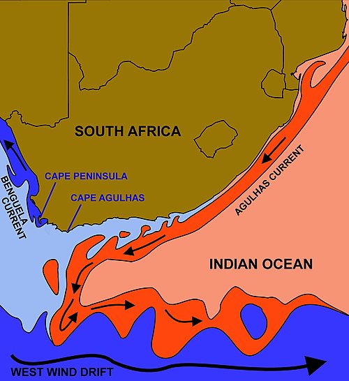
The courses of the warm Agulhas current (red) along the east coast of South Africa, and the cold Benguela current (blue) along the west coast. Note that the Benguela current does not originate from Antarctic waters in the South Atlantic Ocean, but from upwelling of water from the cold depths of the Atlantic Ocean against the west coast of the continent. The two currents do not "meet" anywhere along the south coast of Africa.

Rocky coastal headland and small sandy beach on the Cape Peninsula, with layered sandstone cliffs meeting the ocean.
Table Mountain
Videos
Table Mountain is a flat-topped mountain forming a prominent landmark overlooking the city of Cape Town in South Africa.
Cape Peninsula
…south-western extremity of the African continent. At the southern end of the peninsula are Cape Point and the Cape of Good Hope. On the northern end is Table Mountain, overlooking Table Bay and the City Bowl of Cape Town, South Africa. The peninsula is 52 km long from Mouille point in the north to Cape Point in the…


Table Mountain as seen from Lion's Head, with low-lying cloud cover over Cape Town

Panorama from the top of Table Mountain. From left to right are visible Lion's Head, Signal Hill, Robben Island, the Cape Town city centre, Table Bay, and Devil's Peak.

Devil's Peak, Table Mountain and the Back Table seen from the Cape Flats. In this view Table Mountain is seen "side on" from the east. It is the view of the mountain that greets a visitor to Cape Town arriving by road (particularly along the N2). The distance from Constantia Nek to the lower slopes of Devil's Peak on the right hand side of the photograph is nine kilometres or 5.6 miles (as the crow flies).