Cape Point
Videos
Cape Point is a promontory at the southeast corner of the Cape Peninsula, a mountainous and scenic landform that runs north–south for about thirty kilometres at the extreme southwestern tip of the Afr

Cape Point in the left foreground, with the Cape of Good Hope almost right behind and some 2.3 km away

Looking from behind the old lighthouse (at top left) to the new lighthouse (a sunlit speck of white very near the point). The lighthouses are 700 metres (2,300 ft) apart, and the new lighthouse 162 metres (531 ft) lower in altitude to remain visible during low cloud.
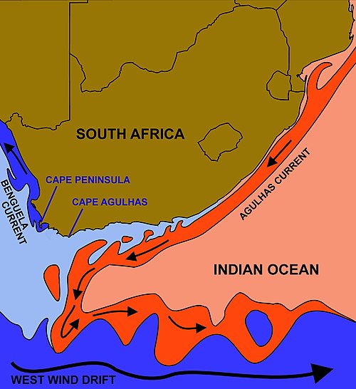
The courses of the warm Agulhas current (red) along the east coast of South Africa, and the cold Benguela current (blue) along the west coast. Note that the Benguela current does not originate from Antarctic waters in the South Atlantic Ocean, but from upwelling of water from the cold depths of the Atlantic Ocean against the west coast of the continent. The two currents do not "meet" anywhere along the south coast of Africa, except as random eddies from the two currents that arise and intermingle west of

The "new" lighthouse of 1919, atop Dias Point, essentially Cape Point
False Bay
Videos
False Bay is a body of water in the Atlantic Ocean between the mountainous Cape Peninsula and the Hottentots Holland Mountains in the extreme south-west of South Africa. The mouth of the bay faces sou
Cape Point
…angling from the rocks very dangerous. Over the years, scores of fishermen have been swept to their deaths from the rocky platforms by freak waves. False Bay, which opens to the east and north of Cape Point, is the location of the well-known naval port of Simon's Town. The bay is also famous – or infamous…

Astronaut photo of Cape Town with False Bay

View of City of Cape Town showing the Cape Peninsula and Cape Flats from the International Space Station

Aerial view of the eastern False Bay coast, looking somewhat south of east: Gordon's Bay (left) to Cape Hangklip (right)

Surfers Corner; A popular surfing spot at Muizenberg in the northwest corner of False Bay