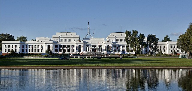
Parkes, Australian Capital Territory
Parkes is an inner southern suburb of the Canberra Central district of Canberra, located within the Australian Capital Territory of Australia. Located south-east of the Canberra central business district, Parkes contains the Parliamentary Triangle and many of the national monuments of Australia's capital city. Parkes is named in honour of Sir Henry Parkes, a Federalist and one of the founders of the Australian Constitution. Streets in Parkes are named after constitutional references. Parkes contains no residential area; as at the 2016 census, Parkes had a population of 5. At the 2011 census, it had no people, but at the 2006 census and the 2001 census censuses, there were four people and 27 people living within the suburb's boundaries. Aboriginal Tent Embassy Commonwealth Park Commonwealth Place East Block Kings Park Central Basin of Lake Burley Griffin High Court of Australia National Carillon National Library of Australia National Gallery of Australia National Portrait Gallery National Rose Garden National Science and Technology Centre Old Parliament House Reconciliation Place Regatta Point West Block The geology of Parkes has been studied in great detail.
Canberra Formation, calcareous shale is found in the lower parts. This overlies middle Silurian Camp Hill Sandstone; the sandstone unconformably overlies the early Silurian Black Mountain Sandstone and State Circle Shale. State Circle Shale is Late Llandovery in a more finely divided time scale and it has been dated to 445 ±7 million years old; the State Circle Shale is composed of laminated shales and siltstone. Black Mountain Sandstone is composed of a white quartz sandstone. Parkes residents get preference for: Forrest Primary Telopea Park School Narrabundah College Parliamentary Triangle
Australian Capital Territory
The Australian Capital Territory known as the Federal Capital Territory until 1938 and referred to as the ACT, is a federal territory of Australia containing the Australian capital city of Canberra and some surrounding townships. It is enclaved within the state of New South Wales. Founded after federation as the seat of government for the new nation, all important institutions of the Australian federal government are centred in the Territory. On 1 January 1901, federation of the colonies of Australia was achieved. Section 125 of the new Australian Constitution provided that land, situated in New South Wales and at least 100 miles from Sydney, would be ceded to the new federal government. Following discussion and exploration of various areas within New South Wales, the Seat of Government Act 1908 was passed in 1908 which specified a capital in the Yass-Canberra region; the territory was transferred to the Commonwealth by New South Wales in 1911, two years prior to the capital city being founded and formally named as Canberra in 1913.
While the overwhelming majority of the population reside in the city of Canberra in the ACT's north-east, the Territory includes some surrounding townships such as Williamsdale, Uriarra and Hall. The ACT includes the Namadgi National Park which comprises the majority of land area of the Territory. Despite a common misconception, the Jervis Bay Territory is not part of the ACT although the laws of the Australian Capital Territory apply as if Jervis Bay did form part of the ACT; the Territory has a dry, contintental climate experiencing warm to hot summers and cool to cold winters. The Australian Capital Territory is home to many important institutions of the federal government, national monuments and museums; this includes the Parliament of Australia, the High Court of Australia, the Australian Defence Force Academy and the Australian War Memorial. It hosts the majority of foreign embassies in Australia as well as regional headquarters of many international organisations, not-for-profit groups, lobbying groups and professional associations.
Several major universities have campuses in the ACT including the Australian National University, the University of Canberra, the University of New South Wales, Charles Sturt University and the Australian Catholic University. A locally elected legislative assembly has governed the Territory since 1988. However, the Commonwealth may overturn local laws, it still maintains control over the area known as the Parliamentary Triangle through the National Capital Authority. Residents of the Territory elect three members to the House of Representatives and two Senators to the Australian Senate. With 419,200 residents, the Australian Capital Territory is second smallest mainland state or territory by population. At the 2016 census, the median weekly income for people in the Territory aged over 15 was $998 and higher than the national average of $662; the average level of degree qualification in the ACT is higher than the national average. Within the ACT, 37.1% of the population hold a bachelor degree level or above education compared to the national figure of 20%.
Indigenous Australian peoples have long inhabited the area. Evidence indicates habitation dating back at least 21,000 years, it is possible that the area was inhabited for longer, with evidence of an Aboriginal presence in south-western New South Wales dating back around 40,000–62,000 years. The principal group occupying the region were the Ngunnawal people. Following European settlement, the growth of the new colony of New South Wales led to an increasing demand for arable land. Governor Lachlan Macquarie supported expeditions to open up new lands to the south of Sydney; the 1820s saw further exploration in the Canberra area associated with the construction of a road from Sydney to the Goulburn plains. While working on the project, Charles Throsby learned of a nearby lake and river from the local Indigenous peoples and he accordingly sent Wild to lead a small party to investigate the site; the search was unsuccessful, but they did discover the Yass River and it is surmised that they would have set foot on part of the future territory.
A second expedition was mounted shortly thereafter and they became the first Europeans to camp at the Molonglo and Queanbeyan Rivers. However, they failed to find the Murrumbidgee River; the issue of the Murrumbidgee was solved in 1821 when Charles Throsby mounted a third expedition and reached the watercourse, on the way providing the first detailed account of the land where Canberra now resides. The last expedition in the region prior to settlement was undertaken by Allan Cunningham in 1824, he reported that the region was suitable for grazing and the settlement of the Limestone Plains followed thereafter. The first land grant in the region was made to Joshua John Moore in 1823 and European settlement in the area began in 1824 with the construction of a homestead by his stockmen on what is now the Acton Peninsula. Moore formally named the property Canberry or Canberra. A significant influx of population and economic activity occurred around the 1850s goldrushes; the goldrushes prompted the establishment of communication between Sydney and the region by way of the Cobb & Co coaches, which transported mail and passengers.
The first post offices opened in Ginninderra in 1859 and at Lanyon in 1860. During colonial times, the European communities of Ginninderra and Tuggeranong settled and farmed the surrounding land; the region was called the Queanbeyan-Yass district, after the two largest towns in the area. The villages of Ginninderra and Tharwa developed to service the local agra
Kingston, Australian Capital Territory
Kingston is the oldest and one of the most densely populated suburbs of Canberra, Australian Capital Territory, Australia. The suburb is named after Charles Cameron Kingston, the former Premier of South Australia and minister in the first Australian Commonwealth Government, it is adjacent to the suburbs of Barton, Fyshwick and Manuka. The suburb of Kingston is situated about 4 km from the centre of Canberra. In the early years of Canberra's development, Eastlake occupied the area now known as Kingston. Eastlake Football and Cricket club is one of the few reminders of Kingston long past. Eastlake was designated as a workers living quarters while the suburb of Forrest was reserved for middle and higher ranking public servants. About 120 portable wooden cottages for construction workers were built at the Causeway in 1925 and 1926. Canberra's first hall for community gatherings and entertainment was at the Causeway where the recreation hall was completed in 1926 with voluntary labour using materials provided by the Federal Capital Commission.
After the second world war, housing at the Causeway and Westlake was considered sub-standard. Although all of the original Westlake cottage have been demolished, the Causeway survives with the original temporary wooden cottages now replaced with brick veneer cottages; as it was separated from the rest of the suburb by Wentworth Avenue and was situated to the north of the railway station the Causeway was a distinct district within the suburb of Kingston, however, it is now abutted by the new Kingston foreshore development. The Causeway it is on the edge of a road called the Causeway, planned as a dam across the Molonglo River that would back up East Lake, planned by Walter Burley Griffin but never built; the cottages at Causeway were designed by HM Rolland and were first erected at Westlake in 1924 Acton and at the Causeway in 1925–1926. The Westlake cottages were sold off from the mid-1950s – last cottage removed in 1965. A number are now down the South Coast. One sits with a new coat of paint, in River Street, Oaks Estate.
A photograph showing one of the cottages on the move is in Westlake One of the Vanished Suburbs of Canberra – Gugler, A. The timber cottages at the Causeway were pulled down; the cottage design, referred to as portable timber cottages, designed by Rolland were based on the cottages erected at Westlake by Contractor John Howie for his married men – built 1922. He built nearby 18 or more timber huts for his single men, known as the Hostel Camp; the Burns Club was founded there in 1924. The following areas are heritage listed: The Kingston/Griffith Garden City heritage precinct, sections 15, 16 and 17 of Kingston and section 22 of Griffith, bounded by Dawes, Howitt and Kennedy streets, Burke Crescent and Cunningham streets and Canberra Avenue; the first stage of the precinct was constructed in 1926 and 1927 to accommodate lower rank public servants and workmen for the opening of the provisional Parliament House in 1927. The listed area is the only part of the original East Lake precinct; the Kingston Powerhouse Historic Precinct.
The powerhouse was the first permanent public building in Canberra. It was closed in 1929, but reactivated for periods between 1936 and 1942 and between 1948 and 1957; the Fitters’ Workshop, the second permanent public building, is in the precinct. The siren and whistle, which signalled times to Government outdoor workers in south Canberra for many years, is included in the listing; some Arizona and Himalayan cypresses near the original government printing works completed in 1927 east of Wentworth Avenue and north of Giles Street. The former Transport Depot, the centre of government transport operations in Canberra from 1927 to 1992 and is notable for the steel welded rigid portal frame, built to support its roof in 1940 and is considered to be one of the earliest examples of this technology in the world of its size; the building has housed The Old Bus Depot Markets since 14 February, 1998. The Causeway Hall, built by voluntary labour in 1925 and served for some time as the city's principal place of entertainment, including as "a picture theatre, dance hall and the venue for other entertainment such as concerts and boxing matches".
The Canberra Baptist Church, 11 Currie Crescent, constructed from 21 March 1928 and dedicated on 24 February 1929. It was the second permanent church built after the founding of Canberra and is considered by the ACT Heritage Council to be "a fine example of the Inter-War Gothic style and its internal and external integrity add to this significance." In recent years Kingston has been redeveloped with medium-density housing including townhouses and units. Most of Kingston south of Kingston Avenue is zoned for a predominant height of "3 storeys, with a maximum height of 4 storeys only where it is not the dominant feature of a street frontage", although there are two high-rise blocks north of the shopping centre and the detached houses in three city blocks in the south have heritage protection; the most recent development is the Kingston Foreshores development in which large numbers of high-value apartments are being built along the foreshores of Lake Burley Griffin. The area had been used for industrial purposes and is located between the Canberra railway station and the Kingston Powerhouse.
These new developments and the rise of a café society have reformed Kingston as one of the most exclusive suburbs in Canberra. The Kingston Foreshores are zoned for four-story units, but six-storey units are permitted under some conditions in some areas. Parts of the Kingston Group Centre are now zo
Forrest, Australian Capital Territory
Forrest is an affluent suburb of Canberra, Australian Capital Territory, Australia. Forrest is named after Sir John Forrest, an explorer, federalist, premier of Western Australia, one of the fathers of the Australian Constitution. Streets in Forrest are named after governors. According to the Australian Bureau of Statistics Forrest is the second most Socio-Economic advantaged location in Australia after the neighbouring suburb of Barton. Forrest is one of the few suburbs in Canberra built to the original Canberra plans, it contains many circular and geometric patterns in its streets and can be quite confusing to drive in. Forrest was renamed from the earlier suburb Blandfordia and gazetted as a suburb in 1928. South Blandfordia became part of the new suburb of Griffith at the same time; the original residents of Forrest were senior public servants who were moved from Melbourne. In the 2016 census, the population of Forrest was 1,615, including 6 Indigenous persons and 1,090 Australian-born persons.
42.7% of dwellings were separate houses, 17.3% were semi-detached, row or terrace houses and 38.9% were flats, units or apartments. 40.7% of the population were professionals, compared to the Australian average of 22.2%. 24.1% worked in central government administration, compared to the Australian average of 1.2% and the Canberra-wide average of 20.1%. The median weekly personal income for people aged 15 years was $1,576, compared to the median Australian income of $662. Forrest Primary School is situated in Hobart Avenue in Forrest, it caters for students in years P-6. The students wear yellow; the school celebrated its fiftieth anniversary on 4 April 2008. Forrest residents get preference for: Forrest Primary Telopea Park School Narrabundah College The suburb includes part of the Manuka shopping centre; the suburb contains a government run primary school. Forrest together with the northern parts of Deakin and Red Hill, represent the most prestigious residential area in Canberra. Most of the area is detached dwellings in which a 1600 m2 block would be on the small side, 2000 m² blocks are not atypical.
Forrest includes several areas that are listed by the ACT Heritage Council, covering most of the suburb: The Blandfordia 4 Precinct, bounded by Arthur Circle, Moresby Street, Mugga Way, Melbourne Avenue and Empire Circuit, developed as three separate residential subdivisions between 1926 and 1965, on Garden City principles. The Blandfordia 5 Precinct, the first stage of, developed in 1926 and 1927 to meet the urgent need for housing for public servants for the opening of the provisional Parliament House in Canberra in 1927, it was planned by Sir John Sulman and the planting was guided by Thomas Charles Weston. The Forrest Housing Precinct, a Garden City precinct, developed in 1926 and 1927; the Forrest Fire Station Precinct, bounded by Canberra Avenue, Empire Circuit, Manuka Circle and Fitzroy Street, built in 1938. Manning Clark's house, 11 Tasmania Circle, designed by Robin Boyd and is an early example of the Boyd Peninsula House design, it was the residence of Manning Clark. The Burns Memorial, a memorial for over 60 years, symbolising the contribution of those of Scottish descent to Australia’s settlement and development and the loyalty and affection in which Scottish communities in Australia held the poet Robert Burns and Scotland at the time.
St Christopher's Cathedral Precinct, the centre of Catholic worship and education in the Archdiocese of Canberra and Goulburn since 1928. Federal Capital Commission Type 15 House, 15 Arthur Circle, designed in 1926 and, according to the Heritage Council, "comprises the only example of a Federal Capital Commission Type 15 residence to have been built in Canberra, being rare as both as a two-storey residence and demonstrating the architectural style of the English Arts and Crafts movement", it is one of four houses of the type that were designed by FCC architects under the influence of Charles Voysey, but the others have been altered. St Andrew’s Church Precinct, opened in 1934 and is one of the largest and most ornate Inter-War Gothic style buildings in the ACT, it has stained glass windows by John Radecki. Free Serbian Orthodox Church, 32 National Circuit, is, according to the Heritage Council, "a successful modern reminder of traditional Serbian church planning." Its murals, which were produced by one elderly artist over a period of nearly 16 years, are considered noteworthy.
The Forrest Housing Precinct is subject to conservation measures to preserve its character. Important values being preserved in the suburb are: The majority of the precinct was constructed in 1926 – 27 to meet the urgent need to provide housing for public servants prior to the opening of the provisional Parliament House in 1927; the Melbourne firm Oakley and Scarborough won a 1924 competition to design the housing for the precinct. The street layout is directly derived from Griffin’s 1913 plan which defined the major axes of Melbourne and Hobart Avenues radiating from Capital Hill and concentric circles; the road layout and subdivision pattern of the precinct is mirrored on the opposite side of Melbourne Avenue. The public domain landscaping of
Manuka, Australian Capital Territory
Manuka is an area in the Inner South district of Canberra, Australia covering parts of the suburbs of Griffith and Forrest. Manuka Shops, Manuka Oval, Manuka Swimming Pool, Manuka Circle take their name from the park in the area; the precinct is named after Manuka Circle, the street which forms the northern boundary of the precinct. Manuka Circle was on Walter Burley Griffin's original plan for Canberra and named after the New Zealand tea tree Leptospermum scoparium; the name Manuka is somewhat peculiar in that it is pronounced by local Canberrans differently from the tree from which it gets its name: compared to for the tree. When Griffin drew up his plans in 1912, there was still some optimism that New Zealand might join the Federation of Australia. Griffin's plans included eight avenues radiating out from Capital Hill named after the capitals of the six states, the capital of the Northern Territory and the capital of New Zealand. Before the name Wellington Avenue was gazetted it was realised that New Zealand was not going to become part of a federation of Australasia and the name was replaced by Canberra Avenue.
Griffin planned that the state capital city avenues were terminated with a park named after the generic botanical name for a native plant from that particular site. Another remnant of Griffin's nomenclature was the Wellington Hotel on the corner of Canberra Avenue and National Circuit, demolished and replaced by the hotel known in 2005 as "Rydges Capital Hill Canberra". Business allotments for Manuka were included in the first auction of city leases in December 1924. At the same time leases were sold in the city, Kingston and Red Hill. Lessees were required to erect buildings of approved design on the blocks within three years; the decision to develop business centres at both Kingston and Manuka, which were within half a mile of each other had been made in the absence of Sir John Sulman, the chair of the Federal Capital Advisory Committee. He recorded his disapproval of the decision. Sulman had designed Manuka and it was intended to be the principal commercial centre on the south side; the decision to allow the development of Eastlake meant that in Manuka investment lagged and building was slow.
Eastlake was preferred by residents as a business centre because of the bigger shops and closer proximity to more homes as well as being closer to the only substantial shop in the Territory, near the Kingston railway station. The opening of the Capitol Theatre and the convent school associated with St Christopher's Catholic cathedral allowed the Manuka businesses to develop competitively. Manuka includes several areas that are listed by the ACT Heritage Council: St Christopher's Cathedral Precinct, the centre of Catholic worship and education in the Archdiocese of Canberra and Goulburn since 1928. St Paul’s Church on the corner of Canberra Avenue and Captain Cook Crescent, which the Heritage Council considers to be an excellent example of an Inter-War Gothic church with Art Deco influences; the church was designed by Sydney Architects Burcham Clamp and Son and dedicated on 6 August 1939. The Manuka Oval and Caretaker’s Cottage, which began to be developed as a sports ground in the early 1920s and began to be developed as a formal enclosed oval in March 1929.
The Heritage Council considers that it is "significant for its continual use as a Canberra sporting facility, retaining an array of features such as the historic tree plantings, the oval, the Caretaker's Cottage and the scoreboard which tell the story of its development as a popular sporting venue." Manuka Swimming Pool on Manuka Circle, completed in 1930. The ACT Heritage Council considers it to be "an important component of the body of ‘Federal Capital’ style public buildings associated with the establishment of Canberra as the National Capital." The Canberra Services Club at 14 Manuka Circle, which the ACT Heritage Council considers to be significant for its association with the provision of hospitality to service personnel by Canberra volunteers during World War II. Lady Gowrie, the wife of the Governor General, played a major role in establishing it, including fund-raising; the Services Club burnt down in April 2011. The former Griffith Child Welfare Centre at 30 Manuka Circle, opened in 1937.
The Heritage Council considers it to be important as the first permanent baby health centre in the ACT. Shops were first built in Manuka between 1925 and 1930. In recent years a collection of outdoor cafes has taken over the more utilitarian shops that dominated the area up to the late 1970s. In the 1960s the precinct included a hardware shop, two supermarkets, a large delicatessen, two butchers, a fishmongers, at least one green grocer, several florists, a boot shop and repairer, clothes shops, home wares and furniture shops, several shoe shops, newsagents, several barbers and hairdressers and a shop selling church candles. Manuka is now known for some nightclubs. Building work commenced on the pool in July 1930, it was the first swimming pool to be built for the city. Before its completion, Canberrans swam in the Molonglo River and other local swimming holes at the Cotter and Murrumbidgee Rivers. Canberra's first pool was built on the south side as it was closer to more Canberra residents than any northside location.
The pool was opened on 26 January 1931. Manuka Oval has a seating capacity of 13,550 people and an overall capacity of 16,000 people, although this is lower for some sports depending on the configura
Walter Burley Griffin
Walter Burley Griffin was an American architect and landscape architect. He is known for designing Australia's capital city, he has been credited with the development of the L-shaped floor plan, the carport and an innovative use of reinforced concrete. Influenced by the Chicago-based Prairie School, Griffin developed a unique modern style, he worked in partnership with his wife Marion Mahony Griffin. In 28 years they designed over 350 buildings and urban-design projects as well as designing construction materials, interiors and other household items. Griffin was born in 1876 in a suburb of Chicago, he was the eldest of the four children of George Walter Griffin, an insurance agent, Estelle Burley Griffin. His family moved to Oak Park and to Elmhurst; as a boy he had an interest in landscape design and gardening, his parents allowed him to landscape the yard at their new home in Elmhurst. Griffin went to Oak Park High School, he considered studying landscape design but was advised by the landscape gardener O. C. Simonds to pursue a more lucrative profession.
Griffin chose to study architecture, and, in 1899, completed his bachelor's degree in architecture at the University of Illinois. The University of Illinois program was run by Nathan Clifford Ricker, a German-educated architect, who emphasized the technical aspects of architecture. During his studies, he took courses in horticulture and forestry. After his studies, Griffin moved to Chicago and was employed as a draftsman for two years in the offices of progressive architects Dwight H. Perkins, Robert C. Spencer, Jr. and H. Webster Tomlinson in "Steinway Hall". Griffin's employers worked in the distinctive Prairie School style; this style is marked by horizontal lines, flat roofs with broad overhanging eaves, solid construction and strict discipline in the use of ornament. Louis Sullivan was influential among Prairie School architects and Griffin was an admirer of his work, of his philosophy of architecture which stressed that design should be free of historical precedent. Other architects of that school include George Grant Elmslie, George Washington Maher, William Gray Purcell, William Drummond and most Frank Lloyd Wright.
In July 1901 Griffin passed the new Illinois architects' licensing examination and this permitted him to enter private practice as an architect. He began to work in Frank Lloyd Wright's famous Oak Park, studios. Although he was never made a partner, Griffin oversaw the construction on many of Wright's noted houses including the Willits House in 1902 and the Larkin Administration Building built in 1904. From 1905 he began to supply landscape plans for Wright's buildings. Wright allowed his other staff to undertake small commissions of their own; the William Emery house, built in Elmhurst, Illinois, in 1903 was such a commission. While working for Wright, Griffin fell in love with Maginel Wright, he proposed marriage to her, but his affections for her were not returned, she refused. In 1906 he resigned his position at Wright's studio and established his own practice at Steinway Hall. Griffin and Wright had fallen out over events following Mr. Wright's trip to Japan in 1905. While Wright was away for five months, Griffin ran the practice.
When Wright returned, he told Griffin that he had overstepped his responsibilities, completing several of Wright's jobs, sometimes substituting his own building designs. Further, Wright had borrowed money from Griffin to pay for his travels abroad, he tried to pay off his debts to Griffin with prints he had acquired in Japan, it became clear to Griffin that Wright would not make Griffin a partner in his business. Griffin's first independent commission was a landscape design for the State Normal School at Charleston, now known as the Eastern Illinois University. In the fall of 1906, he received his first residential job from Harry Peters; the Peters' House was the first house designed with an open floor plan. The L-shape was an economical design and constructed. From 1907, 13 houses in this style were built in the Chicago neighborhood now known as Beverly-Morgan Park. Seven of these houses are on W. 104th Place in Chicago. This street is now named Walter Burley Griffin Place, forms a municipal historical district within the national Ridge Historic District, as it contains the largest collection of small scale Griffin designs.
In 1911 Griffin married Marion Lucy Mahony, a graduate of the Massachusetts Institute of Technology in architecture. She was employed first in Wright's office, by Hermann V. von Holst, who had taken over Wright's work in America when Wright left for Europe in 1909. Marion Mahony recommended to von Holst that he hire Griffin to develop a landscape plan for the area surrounding the three houses on Milliken Place for which Wright had been hired in Decatur, Illinois. Mahony and Griffin worked on the Decatur project before their marriage. After their marriage, Mahony went to work in Griffin's practice. A Walter Burley Griffin and Marion Mahony-designed development with several homes, Rock Crest – Rock Glen in Mason City, Iowa, is seen as their most dramatic American design development of the decade and remains the largest collection of Prairie Style homes surrounding a natural setting. From 1899 to 1914, Griffin created more than 130 designs in his Chicago office for buildings, urban plans and landscapes.
In 1981, the city of Chicago granted landmark status to the Prairie-style bungalows designed between 1909 and 1914 by Griffin in the 1700 block of West 104th Place (also known as the Griffin Place H
Siltstone
Siltstone is a sedimentary rock which has a grain size in the silt range, finer than sandstone and coarser than claystones. Siltstone is a clastic sedimentary rock; as its name implies, it is composed of silt sized particles, defined as grains 2–62 µm or 4 to 8 on the Krumbein phi scale. Siltstones differ from sandstones due to their smaller pores and higher propensity for containing a significant clay fraction. Although mistaken as a shale, siltstone lacks the fissility and laminations which are typical of shale. Siltstones may contain concretions. Unless the siltstone is shaly, stratification is to be obscure and it tends to weather at oblique angles unrelated to bedding. Mudstone or shale are rocks that contain mud, material that has a range of silt and clay. Siltstone is differentiated by having a majority silt, not clay. Cosmetic palette—made exclusively out of siltstone with a few exceptions Folk, R. L. 1965, Petrology of sedimentary rocks PDF version. Austin: Hemphill’s Bookstore. 2nd ed. 1981, ISBN 0-914696-14-9 Williams, Francis J. Turner and Charles M. Gilbert, 1954, Petrography, W. H. Freeman