Castello Plan
Videos
The Castello Plan – officially entitled Afbeeldinge van de Stadt Amsterdam in Nieuw Neederlandt – is an early city map of what is now the Financial District of Lower Manhattan, created from a 1660 ori
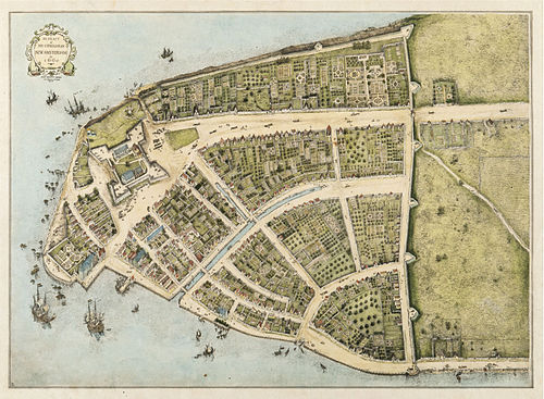
Redraft of the Castello Plan of New Amsterdam in 1660, redrawn in 1916 by John Wolcott Adams and Isaac Newton Phelps Stokes
New Amsterdam
Videos
New Amsterdam was a 17th-century Dutch settlement established at the southern tip of Manhattan Island that served as the seat of the colonial government in New Netherland. The initial trading factory

View of New Amsterdam

1882 depiction of the ship Mayflower sailing from England to America in 1620, in Plymouth Harbor

1626 letter in Dutch by Pieter Schaghen stating the purchase of Manhattan for 60 gulden.

Drawing of New Amsterdam in 1650, discovered in 1991 in the collection of Albertina in Austria. It is probably the oldest, lifelike depiction of the colony