Delta Works
Videos
Photos
The Delta Works is a series of construction projects in the southwest of the Netherlands to protect a large area of land around the Rhine–Meuse–Scheldt delta from the sea. Constructed between 1954 and 1997, the works consist of dams, sluices, locks, dykes, levees, and storm surge barriers located in the provinces of South Holland and Zeeland.

Zeeland Bridge

Oosterscheldekering

Scale model of the Maeslantkering

Image: 1 Stormvloedkering Hollandse I Jssel Algerabrug DSC 0179
Rhine–Meuse–Scheldt delta
Videos
Photos
The Rhine–Meuse–Scheldt delta is a river delta in the Netherlands formed by the confluence of the Rhine, the Meuse and the Scheldt rivers. In some cases, the Scheldt delta is considered a separate delta to the Rhine–Meuse delta. The result is a multitude of islands, branches and branch names, in which a waterway that appears to be one continuous stream may have numerous separate names for different sections, e.g. Rhine → Bijlands Kanaal → Pannerdens Kanaal → Nederrijn → Lek → Nieuwe Maas → Het Scheur → Nieuwe Waterweg. Since the Rhine contributes most of the water, the term "Rhine Delta" is commonly used, although this name is also used for the delta where the Alpine Rhine flows into Lake Constance. By some calculations, the Rhine–Meuse–Scheldt delta covers 25,347 km2 (9,787 sq mi), making it the largest in Europe.
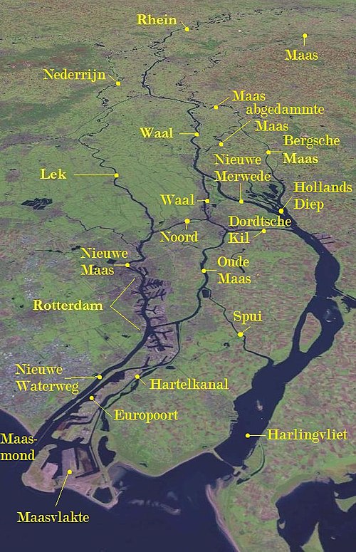
The central and northern parts of the Rhine-Meuse delta (Scheldt not visible)

Satellite image of the Northern part of the Rhine–Meuse–Scheldt delta: 1. Part of the island of Goeree-Overflakkee 2. The island of Tiengemeten 3. The west end of the province of North Brabant 4. The island Voorne 5. The island of Putten 6. The island of Hoeksche Waard 7. The island of Dordrecht 8. The national park of De Biesbosch 9. The island of IJsselmonde 10. The island of Rozenburg 11. Part of the province of South Holland a. The Oude Maasje stream