Drumheller Channels National Natural Landmark showcases the Drumheller Channels, which are the most significant example in the Columbia Plateau of basalt butte-and-basin Channeled Scablands. This National Natural Landmark is an extensively eroded landscape, located in south central Washington state characterized by hundreds of isolated, steep-sided hills (buttes) surrounded by a braided network of numerous channels, all but one of which are currently dry. It is a classic example of the tremendous erosive powers of extremely large floods such as those that reformed the Columbia Plateau volcanic terrain during the late Pleistocene glacial Missoula Floods.
Drumheller Channels

Ice Age Floods Institute tour of the Drumheller Channels – note the two people in the foreground and the group in the background that provide perspective in the large-scale erosion here.
Crab Creek
Videos
Crab Creek is a stream in the U.S. state of Washington. Named for the presence of crayfish, it is one of the few perennial streams in the Columbia Basin of central Washington, flowing from the northeastern Columbia River Plateau, roughly 5 km (3.1 mi) east of Reardan, west-southwest to empty into the Columbia River near the small town of Beverly. Its course exhibits many examples of the erosive powers of extremely large glacial Missoula Floods of the late Pleistocene, which scoured the region. In addition, Crab Creek and its region have been transformed by the large-scale irrigation of the Bureau of Reclamation's Columbia Basin Project (CBP), which has raised water table levels, significantly extending the length of Crab Creek and created new lakes and streams.

Lower Crab Creek above confluence with Red Rock Coulee.

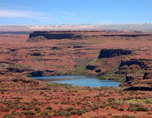
Lower Crab Creek 8 miles (13 km) above the confluence with the Columbia River looking east. Saddle Mountains to the right.

Oversized Crab Creek Coulee showing basalt on far side. Creek on far side of valley.

Crab Creek in the Drumheller Channels.