Fajã is a Portuguese term of obscure origin used to describe supratidal talus at the foot of coastal cliffs, caused by landslides or lava flows. Although relatively common world-wide, they are distinctive features of the Azores and Madeira, as well as of the Canary Islands, where the equivalent term in Canarian Spanish is fajana. The term also designates a small flat piece of land, generally cultivable and located by the sea, formed of materials fallen from cliffs.
Another Canarian word for lava fajanas is isla baja, literally, "low island".
A view of some of the Fajã dos Vimes in the municipality of Calheta
The detritic platform of Fajã da Caldeira de Santo Cristo [pt], with its emblematic lagoon
View of Fajana de Franceses, in the island of La Palma, Spain.
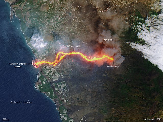
In this satellite view of the 2021 Cumbre Vieja eruption in La Palma, the lava flow falls from the cliffs on the west into the Atlantic and forms a lava delta as a fajana.
São Jorge is an island in the central group of the Azores archipelago and part of the autonomous region of Portugal. Separated from its nearest neighbours by the 15-kilometre (9.3 mi) Pico-São Jorge Channel, the central group is often referred colloquially as part of the Triângulo ("Triangle") group or just "The Triangle". São Jorge is a relatively long thin island with tall cliffs, whose 8,381 inhabitants are concentrated on various geological debris fields (fajãs) along the north and south coasts; from east to west, the island is 53 kilometres (33 mi) long and, north to south, 8 kilometres (5.0 mi) wide: its area is 237.59 square kilometres (91.73 sq mi).
The island of São Jorge seen from the north-northwest coast along the Ponta dos Rosais, Rosais
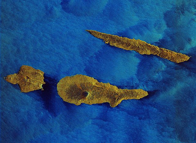
Radar image of São Jorge Island (top) next to Pico and Faial islands
Matrix Church of Nossa Senhora do Rosário, Topo. Built in the 16th century, it is one of the earliest churches on the island of São Jorge
Old windmill, Morro das Velas


![The detritic platform of Fajã da Caldeira de Santo Cristo [pt], with its emblematic lagoon](https://upload.wikimedia.org/wikipedia/commons/thumb/b/b2/SJO_CAL_Ribeira_Seca_Faja_Caldeira_Santo_Cristo.JPG/640px-SJO_CAL_Ribeira_Seca_Faja_Caldeira_Santo_Cristo.JPG)