Geography of Bulgaria
Videos
Bulgaria is a country situated in Southeast Europe that occupies the eastern quarter of the Balkan peninsula, being the largest country within its geographic boundaries. It borders Romania to the north, Serbia and North Macedonia to the west, Greece and Turkey to the south, and the Black Sea to the east. The northern border with Romania follows the river Danube until the city of Silistra. The land area of Bulgaria is 110,994 square kilometres (42,855 sq mi), slightly larger than that of Cuba, Iceland or the U.S. state of Tennessee. Considering its relatively compact territorial size and shape, Bulgaria has a great variety of topographical features. Even within small parts of the country, the land may be divided into plains, plateaus, hills, mountains, basins, gorges, and deep river valleys. The geographic center of Bulgaria is located in Uzana.

A winter view of the Vlahina Mountain near the border with North Macedonia

Belogradchik Rocks, western Balkan Mountains

Devetashka cave, Pre-Balkan

Melnik Earth Pyramids, Pirin Mountains
Pirin
Videos
The Pirin Mountains are a mountain range in southwestern Bulgaria, with the highest peak, Vihren, at an altitude of 2,914 m (9,560 ft).

Pirin scenery in winter
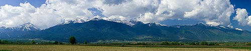
Panorama of Pirin from the Razlog Valley

A view to Sinanitsa

A view to Vihren, Pirin's highest summit